Nab Tower

Last updated

Nab Tower Lighthouse
Image of the Nab Tower after extensive repairs and alterations in 2012..JPG
Nab Tower
LocationNab Rocks, near the Isle of Wight, England
Coordinates 50°40′03″N0°57′04″W / 50.66749733°N 0.951162862°W / 50.66749733; -0.951162862 [1]
Tower
Constructed1918 towed into position 1920
ConstructionSteel and concrete
Automated1983
Height17 m (56 ft) [2]
ShapeBroad cylindrical tower faced with reinforced concrete
MarkingsUnpainted tower, white light
OperatorTrinity House [3]
Fog signal 1 blast every 30s. (range 2 nmi (3.7 km))
Racon T  OOjs UI icon edit-ltr-progressive.svg
Light
First lit1920
Focal height17 m (56 ft)
Light sourceVega LED lantern
Intensity2,850 candela [2]
Range12 nmi (22 km)
Characteristic Fl W 10s.

The Nab Tower is a tower originally planned for anti-submarine protection in the English Channel in World War I. It was sunk over the Nab rocks east of the Isle of Wight to replace a lightship after the war, and is a well-known landmark for sailors as it marks the deep-water eastern entry into the Solent.

Contents

History

The Nab Tower prior to refurbishment Nab Tower lighthouse, east of Culver Cliff - geograph.org.uk - 2612258.jpg
The Nab Tower prior to refurbishment

During the First World War, the British Admiralty designed eight towers codenamed M-N that were to be built and positioned in the Straits of Dover to protect allied merchant shipping from German U-boats. Designed by civilian Guy Maunsell, the towers were to be linked together with steel nets and armed with two 4-inch guns with the idea of closing the English Channel to enemy ships.

However, by the end of the war in 1918 only one such tower had been completed, at the then-cost of one million pounds, and was located at Shoreham Harbour, awaiting deployment. While another part-built tower would eventually be dismantled in 1924, there remained the completed 92-foot-tall (28 m) metal cylinder sitting on a raft of concrete.

In 1920 the completed tower was towed by two paddle-wheel tugs to the Nab rock, a rock in the deep-water approach to the eastern Solent and previously marked by a lightship. [4] Buoyancy was provided by the honeycomb construction of the concrete base, creating 18 watertight compartments. When these were flooded, the structure sank and settled to rest at an angle of 3 degrees from vertical towards the northeast – a characteristic tilt which is obvious to this day. [5]

Pre-1983 optic from the Nab Tower; one of a pair, now on display inside Hurst Castle in Hampshire Optics (4865745080).jpg
Pre-1983 optic from the Nab Tower; one of a pair, now on display inside Hurst Castle in Hampshire

Initially, the tower had a single centrally-placed lamp containing an Osram gas-filled incandescent light bulb, which gave a single white flash every ten seconds, with a visible range of 16 nautical miles. [6] A fog horn was also installed, in a separate shed on the tower top. Later, the single light was replaced by a pair of small (fifth-order) revolving dioptric optics, each of which produced a single flash every 10 seconds; [7] they were mounted in small turrets on opposite sides of the tower: one shone red towards the north-west, the other shone white towards the south-east (their arcs overlapped, so that vessels approaching from seaward would see the red light as well as the white if their course took them too close to St Catherine's Point, approaching from the west, or Selsey Bill, approaching from the east). [8] In December 1935 a radio beacon was added. [9]

In 1938 a more powerful diaphone fog signal was installed (in place of the old fog horn), which gave one 2.5-second blast every minute. [10] It was synchronised with the radio beacon; by timing the delay between receiving the radio signal and the audible signal, vessels were able to calculate their distance from the tower. [11] The tower was equipped with a fog bell, as well as the diaphone, [12] which sounded one stroke every 7.5 seconds. [10]

The Nab Tower was manned as a lighthouse, but also functioned as a Royal Navy signal station; [5] and during World War II it was equipped with a pair of Bofors guns to provide some defence to the Solent approach, and actually shot down several aircraft. [5] The Royal Navy withdrew its personnel from the tower some time after the war, but the tower remained under Ministry of Defence ownership until 1984, when Trinity House acquired the freehold (they had previously taken over responsibility for the light itself from the Admiralty in 1929). [13] [14]

The Nab Tower still functions as a lighthouse, but since 1983 it has been unmanned. That year, a helicopter pad was constructed on the tower and a new pre-fabricated lantern-tower was installed containing an automated acetylene lamp; [5] as well as powering the lamp, acetylene gas drove the revolving mechanism for the lightweight GRP optic in which the lamp was set. [15] In 1995 the light was converted to solar power operation and a new Orga rotating beacon was installed in the lantern (later a Vega VRB-25 rotating beacon was used). [16]

In November 1999, the merchant freighter Dole America, carrying a cargo of bananas and pineapples, hit the Nab. The ship was badly damaged and only avoided sinking by being run aground. The base of the tower suffered superficial and internal damage. The damage was repaired in 2001.

The tower was featured as the main setting of the 1951 Hammer thriller The Dark Light .

Major refurbishment in 2013

In 2013, Trinity House commissioned BAM Nuttall to undertake a major refurbishment programme due to extensive corrosion of the upper levels, meaning it was unsafe to land helicopters upon the helipad. Partial dismantling of the structure followed, undertaken with the help of a tower crane, which was installed within a former ammunition shaft. [17] The height of the tower was reduced from 27 metres to 17, all external steel and cladding were removed and the existing concrete sub-structure was coated in a new layer of gun-applied concrete. On completion, new AIS and RACON beacons were fitted, along with a fixed main LED light (and identical standby light) with a 12 nautical mile range; [18] a new fog signal was also installed, sounding two blasts every 30 seconds (altered to one blast in 2022). [19] All are solar powered.

The distinctive red lantern structure, removed as part of the refurbishment, is now on display at Hurst Castle, [20] together with the old rotating beacon. [21] In addition, a pair of rotating 4th-order dioptric optics, which were in use on the tower prior to automation, are also displayed at the castle. [22]

See also

Related Research Articles

<span class="mw-page-title-main">Longships Lighthouse</span> Lighthouse in England

Longships Lighthouse is an active 19th-century lighthouse about 1.25 mi (2.0 km) off the coast of Land's End in Cornwall, England. It is the second lighthouse to be built on Carn Bras, the highest of the Longships islets which rises 39 feet (12 m) above high water level. In 1988 the lighthouse was automated, and the keepers withdrawn. It is now remotely monitored from the Trinity House Operations & Planning Centre in Harwich, Essex.

<span class="mw-page-title-main">Plymouth Breakwater</span> Breakwater in Plymouth Sound

<span class="mw-page-title-main">Pendeen Lighthouse</span> Lighthouse

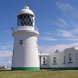
Pendeen Lighthouse, also known as Pendeen Watch is an active aid to navigation located 2 kilometres (1.2 mi) to the north of Pendeen in west Cornwall, England. It is located within the Aire Point to Carrick Du SSSI, the Cornwall Area of Outstanding Natural Beauty and the Penwith Heritage Coast. The South West Coast Path passes to the south.

<span class="mw-page-title-main">Baily Lighthouse</span> Lighthouse on the Howth peninsula, County Dublin, Ireland

The Baily Lighthouse is a lighthouse on the southeastern part of Howth Head in County Dublin, Ireland. It is maintained by the Commissioners of Irish Lights.
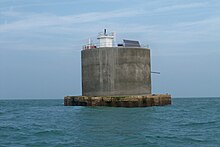
<span class="mw-page-title-main">Royal Sovereign Lighthouse</span> Lighthouse

Royal Sovereign lighthouse is a decommissioned lighthouse marking the Royal Sovereign shoal, a sandbank 11 km (6.8 mi) offshore from Eastbourne. The structure's distinctive shape is easily recognised as the lighthouse tower is perched above a large platform supported by a single pillar rising out of the water. Originally, the platform was manned by three full-time keepers, accommodation being contained in the 'cabin section' immediately below the platform. Additional accommodation was provided for up to four visiting maintenance workers.

<span class="mw-page-title-main">South Foreland Lighthouses</span> Pair of lighthouses in England, United Kingdom

South Foreland Lighthouses are a pair of Victorian lighthouses on the South Foreland in St. Margaret's Bay, Dover, Kent, England, used to warn ships approaching the nearby Goodwin Sands. There has been a pair of lighthouses at South Foreland since at least the 1630s. Even after the decommissioning of the Lower Lighthouse the pair continued to be used as leading marks, with Admiralty charts into the 20th century indicating that the 'Lighthouses in line lead south of the Goodwin Sands'.

<span class="mw-page-title-main">Start Point Lighthouse</span> Lighthouse in south Devon, England

Start Point lighthouse was built in 1836 to protect shipping off Start Point, Devon, England. Open to the public in summer months, it is owned and operated by Trinity House. It has been designated by English Heritage as a grade II listed building.

<span class="mw-page-title-main">Portland Bill Lighthouse</span> Lighthouse on the Isle of Portland, Dorset, England

Portland Bill Lighthouse is a functioning lighthouse at Portland Bill, on the Isle of Portland, Dorset, England. The lighthouse and its boundary walls are Grade II Listed.

<span class="mw-page-title-main">St Bees Lighthouse</span> A lighthouse at St Bees, on the Cumbrian coast, England

St Bees Lighthouse is a lighthouse located on St Bees Head near the village of St Bees in Cumbria, England. The cliff-top light is the highest in England at 102 m (335 ft) above sea level.

<span class="mw-page-title-main">Bull Point Lighthouse</span> Lighthouse on the coast of Devon, England

Bull Point Lighthouse is a lighthouse on Bull Point, about one mile (1.6 km) north of the village of Mortehoe, on the northern coast of Devon, England. The lighthouse provides a visual aid to the villages of Mortehoe, Woolacombe and Ilfracombe, and warns of the inhospitable and rocky coast that lines the area.

<span class="mw-page-title-main">Hurst Point Lighthouse</span> Lighthouse in Hampshire, England

Hurst Point Lighthouse is located at Hurst Point in the English county of Hampshire, and guides vessels through the western approaches to the Solent.

<span class="mw-page-title-main">Wolf Rock Lighthouse</span> Lighthouse

Wolf Rock Lighthouse is on the Wolf Rock, a single rock located 18 nautical miles east of St Mary's, Isles of Scilly and 8 nautical miles southwest of Land's End, in Cornwall, England, United Kingdom. The fissures in the rock are said to produce a howling sound in gales, hence the name.

<span class="mw-page-title-main">Hartland Point Lighthouse</span> Lighthouse in Devon, England

Hartland Point Lighthouse is a Grade II listed building at Hartland Point, Devon, England. The point marks the western limit of the Bristol Channel with the Atlantic Ocean continuing to the west. Trinity House, the lighthouse authority for England and Wales, have a lighthouse on the tip of the peninsula.

<span class="mw-page-title-main">Needles Lighthouse</span> Lighthouse on the Isle of Wight, UK

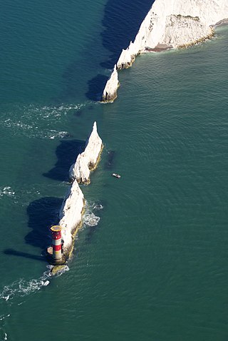
The Needles Lighthouse is an active 19th century lighthouse on the outermost of the chalk rocks at The Needles on the Isle of Wight in the United Kingdom, near sea level. Designed by James Walker, for Trinity House at a cost of £20,000. It was completed in 1859 from granite blocks, stands 33.25 metres (109.1 ft) high and is a circular tower with straight sides. It replaced an earlier light tower on top of a cliff overhanging Scratchell's Bay, which was first lit on 29 September 1786.

<span class="mw-page-title-main">Lowestoft Lighthouse</span> Lighthouse in Lowestoft, England

Lowestoft Lighthouse is a lighthouse operated by Trinity House located to the north of the centre of Lowestoft in the English county of Suffolk. It stands on the North Sea coast close to Ness Point, the most easterly point in the United Kingdom. It acts as a warning light for shipping passing along the east coast and is the most easterly lighthouse in the UK.

<span class="mw-page-title-main">St Catherine's Lighthouse</span> Lighthouse on the southernmost point of the Isle of Wight, England

St Catherine's Lighthouse is a lighthouse located at St Catherine's Point at the southern tip of the Isle of Wight. It is one of the oldest lighthouse locations in Great Britain.

<span class="mw-page-title-main">Flamborough Head Lighthouse</span> Lighthouse

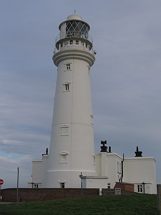
Flamborough Head Lighthouse is an active lighthouse located at Flamborough, East Riding of Yorkshire. England. Flamborough Head Lighthouse acts as a waypoint for passing deep sea vessels and coastal traffic, and marks Flamborough Head for vessels heading towards Scarborough and Bridlington.

<span class="mw-page-title-main">Dungeness Lighthouse</span> Lighthouse

Dungeness Lighthouse on the Dungeness Headland started operation on 20 November 1961. Its construction was prompted by the building of Dungeness nuclear power station, which obscured the light of its predecessor which, though decommissioned, remains standing. The new lighthouse is constructed of precast concrete rings; its pattern of black and white bands is impregnated into the concrete. It remains in use today, monitored and controlled from the Trinity House Operations and Planning Centre at Harwich, Essex.

<span class="mw-page-title-main">Casquets lighthouses</span> Lighthouse

Casquets Lighthouse is an active lighthouse located on the rocky Les Casquets, Alderney, Channel Islands.

<span class="mw-page-title-main">Lighthouses on Lundy</span>

The isle of Lundy has three lighthouses: a pair of active lights built in 1897 and an older lighthouse dating from 1797.

References

  1. Latitude
  2. 1 2 Nab Tower Lighthouse. Retrieved 3 May 2016
  3. Rowlett, Russ. "Lighthouses of Southern England". The Lighthouse Directory. University of North Carolina at Chapel Hill . Retrieved 3 May 2016.
  4. "Nab Tower Lighthouse". Trinity House. Archived from the original on 17 August 2012. Retrieved 24 August 2012.
  5. 1 2 3 4 Woodman, Richard; Wilson, Jane (2002). The Lighthouses of Trinity House. Bradford-on-Avon, Wilts.: Thomas Reed. pp. 96–97.
  6. "Light on the "Mystery Tower"". BEAMA Journal: A Monthly Review of Power and Engineering Progress. 13. 1923.
  7. Jackson, Derrick (1975). Lighthouses of England and Wales. Newton Abbott, Devon: David & Charles. p. 66.
  8. Admiralty Chart, 1954
  9. Hansard, House of Commons vol.311 c.1502 5 May 1936 Directional Wireless (South Coast)
  10. 1 2 List of Lights, Radio Aids, and Fog Signals: British Isles, English Channel and North Sea. Washington DC: U.S. Hydrographic Office. 1958.
  11. Renton, Alan (2001). Lost Sounds: The Story of Coast Fog Signals. Caithness, Scotland: Whittles. p. 147.
  12. Harold Taylor: Nab Tower Lighthouse, Part 1
  13. Millyard, Simon (Summer 2014). "Nab Tower Engineering Works 2013 – 2014". Flash (21): 4–5. Retrieved 20 March 2019.
  14. Hansard, House of Commons vol.226 c.1674 19 March 1929 Army And Air Force (Annual) Bill
  15. Naish, John Michael (1985). Seamarks: Their History and Development. London: Stanford Maritime. p. 163.
  16. "Nab Tower". Trinity House. Archived from the original on 29 May 2011. Retrieved 4 May 2010.
  17. "NAB Tower Engineering Works: The final Project Phase". Flash (Trinity House) (22): 6–7. Winter 2014. Retrieved 16 January 2020.
  18. "Renovation of Nab Tower lighthouse begins". Maritime Journal. Retrieved 12 December 2014.[ permanent dead link ]
  19. "Notice to Mariners, 09/03/2022: 17/2022 Nab Tower Lighthouse". Trinity House. Retrieved 26 October 2022.
  20. "The Association of Lighthouse Keepers". Hurst Castle. Retrieved 20 March 2019.
  21. photo
  22. "Photo". Alamy. Retrieved 20 March 2019.