Tater Du Lighthouse

Last updated

Tater Du Lighthouse
Tater-du Lighthouse (9336281426).jpg
Tater Du Lighthouse in 2013
Tater Du Lighthouse
Location Penzance
Cornwall
England
Coordinates 50°03′09″N5°34′39″W / 50.052394°N 5.577372°W / 50.052394; -5.577372
Tower
Constructed1965
Constructionconcrete block tower
Automated1965
Height15 metres (49 ft)
Shapecylindrical tower with balcony and lantern
Markingswhite tower and lantern
OperatorTrinity House
Light
Focal height34 metres (112 ft)
Lens4th Order 250Mm Rotating Catadioptric Optic (1965-2022)
Light sourceLED
Intensity96,000 candela [1]
Range12 nautical miles (22 km; 14 mi)
Characteristic Fl (3) W 15s.

Tater Du Lighthouse is Cornwall's most recently built lighthouse. The construction of the lighthouse came out of the tragedy of losing a small Spanish coaster called the Juan Ferrer on 23 October 1963, on the nearby Boscawen Point, the vessel capsized with the loss of 11 lives. [2] After the tragedy the Newlyn and Mousehole Fishermen's Association put pressure on Trinity House for a lighthouse to be built, stating that similar tragedies could happen again. The lighthouse, built with concrete blocks, was first lit in July 1965. [3]

Contents

Description

The short building is topped by a 7-foot 1 inch lantern with an electric light which is powered from batteries which are charged from mains electricity during the day. The light is 3 white lights flashed every 15 seconds, with a range of 20 nautical miles (37 km; 23 mi). There is a separate red fixed light that shows in the line over the Runnelstone Rock, shone from a lower window in the tower.

The lighthouse looks out over the Inner and Outer Bucks, two rocks that partially show at low water, and where in 1868 the SS Garonne was lost. [3]

History

Designed by Michael H. Crisp, the lighthouse was constructed with a completely automatic installation which was remotely controlled from the Trinity House depot in Penzance. [3] In 1997 the lighthouse was modernised and it is now monitored from the Trinity House Planning Centre at Harwich. [1]

In May 2022, as part of Trinity House's lighthouse modernisation programme, the revolving optic was replaced with static LED lanterns. At the same time the light's visible range was reduced from 20 nautical miles (37 km; 23 mi) to 12 nmi (22 km; 14 mi). [4]

Fog signal

The fog signal was originally a series (72 in total) of Tannoy units built into the lighthouse tower; they were powered by an alternator coupled to a 2-cylinder Ruston diesel engine. [5] This was later replaced by a short-range Pharos Marine Omnidirectional electric emitter sounding the same characteristic of two one second blasts every 30 seconds during fog. [1] The fog signal was decommissioned in 2012. [6]

Surrounding area

The coastal slope and cliffs around the lighthouse are designated the Tater–du SSSI (a Site of Special Scientific Interest) notified in 1992 because ″... it provides unique evidence of the geological history of SW England during the Variscan orogeny, in particular because of the occurrence of pillow lavas.″ The cliffs are also a Geological Conservation Review site. [7]

The nearby rocks (Inner and Outer Bucks) form a popular sub-aqua dive site. [8] [9] The nearest point for launching a dive-boat is Penzance, as Lamorna Cove just around the corner from The Bucks, does not allow launching from there.

See also

Related Research Articles

<span class="mw-page-title-main">Longships Lighthouse</span> Lighthouse in England

Longships Lighthouse is an active 19th-century lighthouse about 1.25 mi (2.0 km) off the coast of Land's End in Cornwall, England. It is the second lighthouse to be built on Carn Bras, the highest of the Longships islets which rises 39 feet (12 m) above high water level. In 1988 the lighthouse was automated, and the keepers withdrawn. It is now remotely monitored from the Trinity House Operations & Planning Centre in Harwich, Essex.

<span class="mw-page-title-main">Bishop Rock</span> Skerry in the Atlantic Ocean off the coast of Cornwall, England

The Bishop Rock is a skerry off the British coast in the northern Atlantic Ocean known for its lighthouse. It is in the westernmost part of the Isles of Scilly, an archipelago 45 kilometres off the southwestern tip of the Cornish peninsula of Great Britain. The Guinness Book of Records lists it as the world's smallest island with a building on it.

<span class="mw-page-title-main">Pendeen Lighthouse</span> Lighthouse

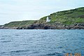
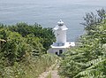
Pendeen Lighthouse, also known as Pendeen Watch is an active aid to navigation located 2 kilometres (1.2 mi) to the north of Pendeen in west Cornwall, England. It is located within the Aire Point to Carrick Du SSSI, the Cornwall Area of Outstanding Natural Beauty and the Penwith Heritage Coast. The South West Coast Path passes to the south.

<span class="mw-page-title-main">Trevose Head Lighthouse</span> Lighthouse on the north coast of Cornwall, England

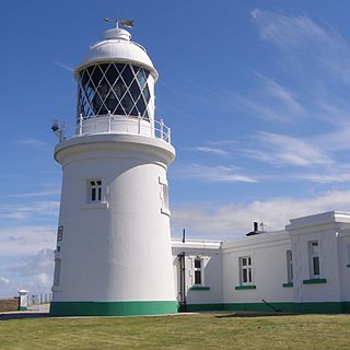
Trevose Head Lighthouse is a lighthouse on Trevose Head on the north Cornish coast at grid reference SW850766 lying to the WSW of Padstow and was sited here as there was previously no light from Land's End to Lundy and it would be visible from Cape Cornwall to Hartland Point.

<span class="mw-page-title-main">St Anthony's Lighthouse</span> Lighthouse

St Anthony's Lighthouse is the lighthouse at St Anthony Head, on the eastern side of the entrance to Falmouth harbour, Cornwall, UK. The harbour is also known as Carrick Roads and is one of the largest natural harbours in the world.

<span class="mw-page-title-main">Lizard Lighthouse</span> Lighthouse on the south coast of Cornwall, England

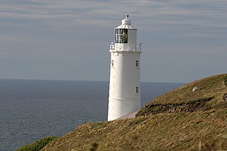
The Lizard Lighthouse is a lighthouse at Lizard Point, Cornwall, England, built to guide vessels passing through the English Channel. It was often the welcoming beacon to persons returning to England, where on a clear night, the reflected light could be seen 100 mi (160 km) away.

<span class="mw-page-title-main">Round Island Light, Isles of Scilly</span> Lighthouse

Round Island Lighthouse, in the Isles of Scilly was designed by William Tregarthen Douglass for Trinity House and completed in 1887. At the time of building it was one of three lights in the Isles of Scilly, the others being the Bishop Rock and St Agnes lighthouse. The light was modernised in 1966, automated in 1987 and the island designated as a Site of Special Scientific Interest (SSSI) in 1995. It is now managed by the Isles of Scilly Wildlife Trust, and except for the maintenance of the Grade II listed lighthouse, landing is not allowed.

<span class="mw-page-title-main">Beachy Head Lighthouse</span> Lighthouse at Beachy Head, East Sussex, England

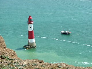
Beachy Head Lighthouse is a lighthouse located in the English Channel below the cliffs of Beachy Head in East Sussex. It is 33 m (108 ft) in height and became operational in October 1902. It was the last traditional-style 'rock tower' to be built by Trinity House.

<span class="mw-page-title-main">Portland Bill Lighthouse</span> Lighthouse on the Isle of Portland, Dorset, England

Portland Bill Lighthouse is a functioning lighthouse at Portland Bill, on the Isle of Portland, Dorset, England. The lighthouse and its boundary walls are Grade II Listed.

<span class="mw-page-title-main">St Bees Lighthouse</span> A lighthouse at St Bees, on the Cumbrian coast, England

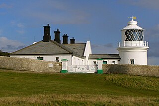
St Bees Lighthouse is a lighthouse located on St Bees Head near the village of St Bees in Cumbria, England. The cliff-top light is the highest in England at 102 m (335 ft) above sea level.

<span class="mw-page-title-main">Bull Point Lighthouse</span> Lighthouse on the coast of Devon, England

Bull Point Lighthouse is a lighthouse on Bull Point, about one mile (1.6 km) north of the village of Mortehoe, on the northern coast of Devon, England. The lighthouse provides a visual aid to the villages of Mortehoe, Woolacombe and Ilfracombe, and warns of the inhospitable and rocky coast that lines the area.

<span class="mw-page-title-main">Wolf Rock Lighthouse</span> Lighthouse

Wolf Rock Lighthouse is on the Wolf Rock, a single rock located 18 nautical miles east of St Mary's, Isles of Scilly and 8 nautical miles southwest of Land's End, in Cornwall, England. The fissures in the rock are said to produce a howling sound in gales, hence the name.

<span class="mw-page-title-main">Hartland Point Lighthouse</span> Lighthouse in Devon, England

Hartland Point Lighthouse is a Grade II listed building at Hartland Point, Devon, England. The point marks the western limit of the Bristol Channel with the Atlantic Ocean continuing to the west. Trinity House, the lighthouse authority for England and Wales, have a lighthouse on the tip of the peninsula.

<span class="mw-page-title-main">Berry Head Lighthouse</span> Lighthouse in Devon, England

Berry Head Lighthouse is an active lighthouse, located at the end of Berry Head near Brixham in Devon, which has been in operation since 4 May 1906. Berry Head is reputedly the shortest lighthouse in Great Britain, but also one of the highest, being only 5 metres (16 ft) tall, but 58 metres (190 ft) above mean sea level. It was also said to be the deepest because the optic was originally turned by a weight falling down a 45 metres (148 ft) deep shaft.

<span class="mw-page-title-main">Peninnis Head</span> Headland on St Marys, Isles of Scilly

Peninnis Head is the southernmost point of St Mary's, Isles of Scilly. The headland is within the Isles of Scilly Area of Outstanding Natural Beauty and part of the Heritage Coast. It is also a Geological Conservation Review site for its Quaternary geomorphology and was first designated a Site of Special Scientific Interest (SSSI) in 1971 for both its biological and geological interests. On the tip of the headland is a squat lighthouse built in 1911 by Trinity House as a replacement for the 17th century lighthouse on St Agnes.

<span class="mw-page-title-main">Anvil Point Lighthouse</span> Lighthouse

The Anvil Point Lighthouse is a fully-automated lighthouse located at Durlston Country Park near Swanage in Dorset, England. It is owned by Trinity House and currently operated as two holiday cottages.

<span class="mw-page-title-main">Flamborough Head Lighthouse</span> Lighthouse

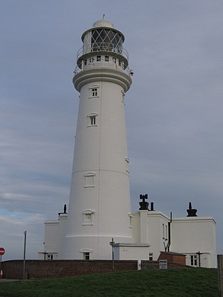
Flamborough Head Lighthouse is an active lighthouse located at Flamborough, East Riding of Yorkshire. England. Flamborough Head Lighthouse acts as a waypoint for passing deep sea vessels and coastal traffic, and marks Flamborough Head for vessels heading towards Scarborough and Bridlington.

<span class="mw-page-title-main">Peninnis Lighthouse</span> Lighthouse

Peninnis Lighthouse is situated on Peninnis Head, St Mary's, Isles of Scilly.

<span class="mw-page-title-main">Casquets lighthouses</span> Lighthouse

Casquets Lighthouse is an active lighthouse located on the rocky Les Casquets, Alderney, Channel Islands.

<span class="mw-page-title-main">Lighthouses on Lundy</span>

The isle of Lundy has three lighthouses: a pair of active lights built in 1897 and an older lighthouse dating from 1797.

References

  1. 1 2 3 "Tater Du Lighthouse". Trinity House. Retrieved 15 May 2019.
  2. Denton, Tony; Leach, Nicholas (2007). Lighthouses of England and Wales. Ashbourne: Landmark Publishing Ltd.
  3. 1 2 3 Noall, Cyril (1968). Cornish Lights and Shipwrecks. Truro: D. Bradford Barton.
  4. "Notice to Mariners, 25/03/2022: 18/2022 Tater Du Lighthouse". Trinity House. Retrieved 25 October 2022.
  5. Renton, Alan (2001). Lost Sounds: The Story of Coast Fog Signals. Caithness, Scotland: Whittles. p. 184.
  6. "Trevose Head and Tater Du fog horns switched off". BBC News. 26 January 2012. Retrieved 4 April 2019.
  7. "Tater-du SSSI" (PDF). Natural England. Archived from the original (PDF) on 24 October 2012. Retrieved 6 November 2011.
  8. "Some Cornish Dive Sites". Totnes BSAC. Archived from the original on 27 February 2012. Retrieved 17 July 2012.
  9. "Dive Sites. Mounts Bay to Lands End". UKDiving. Retrieved 17 July 2012.