
Bodmin is a town and civil parish in Cornwall, England, United Kingdom. It is situated south-west of Bodmin Moor.

Fowey is a port town and civil parish at the mouth of the River Fowey in south Cornwall, England, United Kingdom. The town has been in existence since well before the Norman invasion, with the local church first established some time in the 7th century; the estuary of the River Fowey forms a natural harbour which enabled the town to become an important trading centre. Privateers also made use of the sheltered harbourage. The Lostwithiel and Fowey Railway brought China clay here for export.

St Austell is a town in Cornwall, England, United Kingdom, 10 miles (16 km) south of Bodmin and 30 miles (48 km) west of the border with Devon.
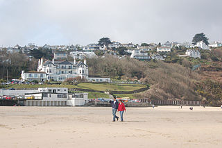
Carbis Bay is a seaside resort and village in Cornwall, England. It lies 1 mile (1.6 km) southeast of St Ives, on the western coast of St Ives Bay, on the Atlantic coast. The South West Coast Path passes above the beach.

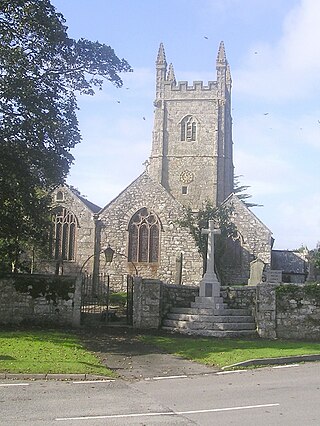
St Columb Major is a town and civil parish in Cornwall, England, United Kingdom. Often referred to locally as St Columb, it is approximately seven miles (11 km) southwest of Wadebridge and six miles (10 km) east of Newquay The designation Major distinguishes it from the nearby settlement and parish of St Columb Minor on the coast. An electoral ward simply named St Columb exists with a population at the 2011 census of 5,050. The town is named after the 6th-century AD Saint Columba of Cornwall, also known as Columb.

Rock is a coastal fishing village in Cornwall, England, United Kingdom. It is opposite Padstow on the north-east bank of the River Camel estuary. The village is in the civil parish of St Minver Lowlands about 4 miles (6.4 km) north-west of Wadebridge.

Chacewater is a village and civil parish in Cornwall, England, UK. It is situated approximately 3 miles (4.8 km) east of Redruth. The hamlets of Carnhot, Cox Hill, Creegbrawse, Hale Mills, Jolly's Bottom, Salem, Saveock, Scorrier, Todpool, Twelveheads and Wheal Busy are in the parish. The electoral ward is called Chacewater & Kenwyn. At the 2011 census a population of 3,870 was quoted.
Stithians, also known as St Stythians, is a village and civil parish in Cornwall, England, United Kingdom. It lies in the middle of the triangle bounded by Redruth, Helston and Falmouth. Its population (2001) is 2,004, increasing to 2,101 at the 2011 census An electoral ward in the same name also exists but stretches north to St Day. The population here also at the 2011 census was 5,023.
Luxulyan, also spelt Luxullian or Luxulian, is a village and civil parish in mid Cornwall, England, United Kingdom. The village lies four miles (6.5 km) northeast of St Austell and six miles (10 km) south of Bodmin. The population of the parish was 1,371 in the 2001 census. This had risen to 1,381 at the 2011 census.
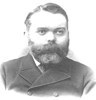
Silvanus Trevail was a British architect, and the most prominent Cornish architect of the 19th century.

Mullion is a civil parish and village on the Lizard Peninsula in south Cornwall, England, United Kingdom. The nearest town is Helston approximately 5 miles (8 km) to the north.

St Agnes is a civil parish and a large village on the north coast of Cornwall, England, United Kingdom. The village is about five miles (8 km) north of Redruth and ten miles (16 km) southwest of Newquay. An electoral ward exists stretching as far south as Blackwater. The population at the 2011 census was 7,565.

St Dennis is a civil parish and village in Cornwall, England, United Kingdom. The village is situated on the B3279 between Newquay and St Austell.

St Stephen-in-Brannel is a civil parish and village in mid Cornwall, England, United Kingdom. St Stephen village is four miles (6.5 km) west of St Austell on the southern edge of Cornwall's china clay district. The parish also contains the villages of Foxhole, Nanpean, Treviscoe and Whitemoor, and the hamlets of Carpalla, Coombe, Currian Vale, High Street, Hornick, Lanjeth, Stepaside and Terras. The population of the civil parish at the 2011 census was 7,119. An electoral ward also exists simply bearing the name St. Stephen. The population at the same census was 4,772 only.

Roche is a civil parish and village in mid-Cornwall, England, United Kingdom. The village gets its name from the 20-metre (66-foot) high Roche Rock, a quartz-schorl outcrop east of the village. Roche is the Norman-French word for Rock. The parish population at the 2011 census including Belowda, Bilberry, Carbis, Coldvreath and Criggan is 3,381, and the ward population at the same census was 3,867.

Lelant is a village in west Cornwall, England, UK. It is on the west side of the Hayle Estuary, about 2+1⁄2 miles (4.0 km) southeast of St Ives and one mile (1.6 km) west of Hayle. The village is part of St Ives civil parish, the Lelant and Carbis Bay ward on Cornwall Council, and also the St Ives Parliamentary constituency. The birth, marriage, and death registration district is Penzance. Its population at the 2011 census was 3,892 The South West Coast Path, which follows the coast of south west England from Somerset to Dorset passes through Lelant, along the estuary and above Porth Kidney Sands.

Pentewan is a coastal village and former port in south Cornwall, England, United Kingdom. It is situated at grid reference SX 019 472 3 miles (4.8 km) south of St Austell at the mouth of the St Austell River.

Troon is a village in Cornwall, UK, 1+1⁄2 miles southeast of Camborne. The village lies at around 560 feet (170 m) above sea level. An electoral ward named Troon and Beacon covers the area north from Troon to the outskirts of Camborne. The population at the 2011 census was 5,410.
Trethurgy is a village in the parish of Treverbyn, Cornwall, England, United Kingdom. It is about two miles northeast of St Austell. Carne Farm, Trethurgy is the birthplace of Silvanus Trevail, a president of the Society of Architects and the architect of many well known Cornish hotels such as the Headland Hotel, Newquay and the Carbis Bay Hotel, Carbis Bay.
The following is a timeline of the history of St Columb Major, Cornwall, England, United Kingdom.


