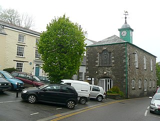
Camelford is a town and civil parish in north Cornwall, England, United Kingdom, situated in the River Camel valley northwest of Bodmin Moor. The town is approximately ten miles (16 km) north of Bodmin and is governed by Camelford Town Council. Lanteglos-by-Camelford is the ecclesiastical parish in which the town is situated. The ward population at the 2011 Census was 4,001. The town population at the same census was 865.

Callington is a civil parish and town in east Cornwall, England, United Kingdom about 7 miles (11 km) north of Saltash and 9 miles (14 km) south of Launceston.

Tregony, sometimes in the past Tregoney, is a village and former civil parish, now in the parish of Tregony with Cuby, in Cornwall, England, United Kingdom. It lies on the River Fal. In the village there is a post office, The Kings Arms Pub, shop, a sports and social club and two churches. Tregony has bus links to the nearest city, Truro. Cornelly parish was united with Tregony in 1934. On 1 April 2021 the parish was abolished and merged with Cuby to form "Tregony with Cuby". Tregony was once a port, but clay mining upriver in St Austell has caused the river to become silted over. The population was 768 in 2011 with nearly 15% claiming Cornish identity.

Calstock is a civil parish and a large village in south east Cornwall, England, United Kingdom, on the border with Devon. The village is situated on the River Tamar 6 miles (9.7 km) south west of Tavistock and 10 miles (16 km) north of Plymouth.

Boyton is a civil parish and village in Cornwall, England, United Kingdom. It is situated close to the River Tamar and the border with Devon about six miles (10 km) north of Launceston. According to the 2001 census it had a population of 378.This increased to 457 at the 2011 census.

Treverbyn is a civil parish and village in mid-Cornwall, England, United Kingdom, lying north of St Austell.
St Newlyn East is a civil parish and village in Cornwall, England, United Kingdom. The village is approximately three miles (5 km) south of Newquay. The name St Newlyn East is locally abbreviated to Newlyn East and according to an anonymous historian writing in The Cornishman in 1880 it was only in recent years that Saint had been added to the parish name.

Gerrans is a coastal civil parish and village on the Roseland Peninsula in Cornwall, England, United Kingdom. The village adjoins Portscatho on the east side of the peninsula. The village is situated approximately seven miles (11 km) south-southeast of Truro.
Philleigh is a civil parish and village in Cornwall, England, one of the four civil parishes in the Roseland Peninsula. The civil parish includes the hamlets of Treworlas, Treworthal and a number of smaller settlements.

Stoke Climsland is a village in the valley of the River Tamar, Cornwall, England, United Kingdom within the civil parish of Stokeclimsland. The population of the parish including Luckett at the 2011 census was 1,703. An electoral ward of the same name also exists. At the same census the population was 3,703.

Menheniot is a civil parish and village in Cornwall, England, United Kingdom. The village is 2+1⁄2 miles (4.0 km) southeast of Liskeard. The meaning of the name is "sanctuary of Neot".
Rame is a village and former civil parish, now in the parish of Maker-with-Rame, in the Cornwall district, in the ceremonial county of Cornwall, England. It is situated on the Rame Peninsula, between Rame Head and the village of Cawsand, in South East Cornwall. In 1931 the parish had a population of 501. On 1 April 1950 the parish was abolished and merged with Maker to form "Maker with Rame". Rame means the high protruding cliff, or possibly, the ram's head.
Linkinhorne is a civil parish and village in southeast Cornwall, England, United Kingdom. The village itself is situated at grid reference SX 320 736 and is approximately four miles (6.5 km) northwest of Callington and seven miles (11 km) south of Launceston. The parish population at the 2011 census including Downgate was 1,541

Week St Mary is a village and civil parish in northeast Cornwall, England, United Kingdom. It is situated south of Bude close to the River Tamar and the border between Cornwall and Devon in the Hundred of Stratton. The parish population at the 2011 census is 657.

St Gennys is a coastal civil parish and small settlement in north Cornwall, England, United Kingdom.

Lawhitton is a village in the civil parish of Lawhitton Rural, in east Cornwall, England, United Kingdom. The village is situated two miles (3 km) southwest of Launceston and half-a-mile west of Cornwall's border with Devon at the River Tamar.

Lezant is a civil parish and village in east Cornwall, England, United Kingdom. Lezant village is about five miles south of Launceston. The population of the parish in the 2001 census was 751, increasing slightly to 765 in the 2011 census.
Poundstock is a civil parish and a hamlet on the north coast of Cornwall, England, United Kingdom. The hamlet is situated four miles (6.5 km) south of Bude half-a-mile west of the A39 trunk road about one mile from the coast.

Lansallos is a village in the civil parish of Polperro in south Cornwall, England, United Kingdom. It is situated between Polruan and Polperro about 5 miles (8 km) east of Fowey in Liskeard Registration District.

St Mellion is a village and rural civil parish in east Cornwall, England, United Kingdom. The parish is about 3 miles (5 km) south of Callington and is in the St Germans Registration District. To the north, the parish is bordered by Callington and St Dominick parishes, to the east and south by Pillaton parish, and to the west by St Ive parish.


