
Bodmin Moor is a granite moorland in north-eastern Cornwall, England, United Kingdom. It is 208 square kilometres (80 sq mi) in size, and dates from the Carboniferous period of geological history. It includes Brown Willy, the highest point in Cornwall, and Rough Tor, a slightly lower peak. Many of Cornwall's rivers have their sources here. It has been inhabited since at least the Neolithic era, when early farmers started clearing trees and farming the land. They left their megalithic monuments, hut circles and cairns, and the Bronze Age culture that followed left further cairns, and more stone circles and stone rows. By medieval and modern times, nearly all the forest was gone and livestock rearing predominated.

The River Camel is a river in Cornwall, England. It rises on the edge of Bodmin Moor and with its tributaries its catchment area covers much of North Cornwall. The river flows into the eastern Celtic Sea between Stepper Point and Pentire Point having covered about 30 miles (50 km) making it the second longest river wholly in Cornwall. The river is tidal upstream to Egloshayle and is popular for sailing, birdwatching and fishing. The name Camel comes from the Cornish language for 'the crooked one', a reference to its winding course. Historically the river was divided into three named stretches. Heyl was the name for the estuary up to Egloshayle, the River Allen was the stretch between Egloshayle and Trecarne, whilst the Camel was reserved for the stretch of river between its source and Trecarne.

North Cornwall is an area of Cornwall, England, United Kingdom. It is also the name of a former local government district, which was administered from Bodmin and Wadebridge 50.516°N 4.835°W. Other towns in the area are Launceston, Bude, Padstow, and Camelford.

The Bodmin and Wenford Railway is a 6 miles 12 chains (9.9 km) heritage railway at Bodmin in Cornwall, England. Its headquarters are at Bodmin General railway station and it connects with the national rail network at Bodmin Parkway.

Wadebridge is a town and civil parish in north Cornwall, England, United Kingdom. The town straddles the River Camel five miles upstream from Padstow. The permanent population was 6,222 in the census of 2001, increasing to 7,900 in the 2011 census. There are two electoral wards in the town. Their total population is 8,272.

The Bodmin and Wadebridge Railway was a railway line opened in 1834 in Cornwall, England, United Kingdom. It linked the quays at Wadebridge with the town of Bodmin and also to quarries at Wenfordbridge. Its intended traffic was minerals to the port at Wadebridge and sea sand, used to improve agricultural land, inwards. Passengers were also carried on part of the line.

The Great Western Railway (GWR) 1366 Class is a class of 0-6-0 pannier tank steam locomotives built in 1934. They were a useful design and because of their light weight and short wheelbase and were often used on dockside branches or other lines with sharp curvatures.

The Camel Trail is a permissive cycleway in Cornwall, England, United Kingdom, that provides a recreational route for walkers, runners, cyclists and horse riders. As a rail trail, the route has only a slight incline following the River Camel from Padstow to Wenford Bridge via Wadebridge and Bodmin, at a total of 18.3 miles (29.5 km) long.

Alfred and Judy are two 0-4-0 saddle tank steam locomotives. They were built by W. G. Bagnall for use at Par Docks in Cornwall, United Kingdom. The unusually low design was required to cope with extremely tight curves and a very low bridge under the Cornish Main Line. The locomotives are both preserved in operational condition on the nearby Bodmin and Wenford Railway and inspired the Reverend Wilbert Awdry to include them in The Railway Series of children's books as Bill and Ben.

The North Cornwall Railway (NCR) also known as the North Cornwall Line, was a standard gauge railway line running from Halwill in Devon, to Padstow in Cornwall, at a distance of 49 miles 67 chains via Launceston, Camelford and Wadebridge. The line was opened in late 19th century by the North Cornwall Railway Company with support throughout much of its construction and existence by the London and South Western Railway (LSWR).

Wadebridge railway station was a railway station that served the town of Wadebridge in Cornwall, England. It was on the Bodmin and Wadebridge Railway.

St Breward is a civil parish and village in Cornwall, England, United Kingdom. It is on the western side of Bodmin Moor, about 6 miles (10 km) north of Bodmin. At the 2011 census the parish population including Cooksland and Fentonadle was 919.
There are eight disused railway stations between Wadebridge and Bodmin North on the former Bodmin and Wadebridge Railway in Cornwall, in the United Kingdom, with ten other closed sidings on the branches to Ruthern Bridge and Wenfordbridge. The section from Boscarne Junction to Bodmin General is currently part of the Bodmin and Wenford Steam Railway; the line from Wadebridge to Wenfordbridge is now part of the Camel Trail, and the line to Ruthern Bridge can be followed for much of its length as it runs parallel to a public road.
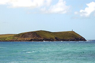
Stepper Point is a headland on the Atlantic coast in north Cornwall, England, United Kingdom. It is at grid reference SW911781. Stepper Point and Pentire Point stand at either side of the mouth of the River Camel; Stepper to the south-west, Pentire to the north-east.

The De Lank River is a small river in north Cornwall, England. It is a tributary of the River Camel and is approximately nine miles (14.5 km) long from its source on Bodmin Moor to its confluence with the Camel two miles (3 km) south of St Breward.
Lank is a settlement in Cornwall, England, United Kingdom. It is situated approximately one mile (1.6 km) south of St Breward and six miles (10 km) east-northeast of Wadebridge in St Breward civil parish. It is in the civil parish of Blisland.

Wenfordbridge, or Wenford Bridge, is a hamlet some 6 miles (9.7 km) north of Bodmin and on the western flank of Bodmin Moor, in Cornwall, England. It takes its name from an old granite bridge over the River Camel, and lies on the border between the parishes of St Breward and St Tudy.

Ruthernbridge is a village in the parish of Withiel in Cornwall, England, UK.
Mulberry Downs Quarry is a disused opencast tin mine in Cornwall, England, UK. Today the site is described as a 'chasm' being a steep or sheer-sided pit 700 foot (210 m) long and up to 100 foot (30 m) deep, and the quarry and immediate surroundings are heavily wooded. The quarry was designated as a Site of Special Scientific Interest (SSSI) in 1973 for its geological interest.
The Cornish China Clay Branches are a number of railway branch lines that serve facilities that produce or process China Clay. The area of Cornwall north of St Austell stretching from Bodmin Moor towards Truro is known for the extraction and processing of commercial volumes of China Clay, and with the expansion of the railways in the 19th century a number of lines were constructed to access various mines and clay-dries. Some branches have closed over the years, but several still operated into the 21st century although much of the China Clay traffic has transferred to road transport. In 2020 rail traffic remained in the shape of regular trains running between Parkandillack and the wharves at Carne Point where the large volumes required to be loaded onto ships for export would make road transport uneconomic.

