
The Cape Schanck Lighthouse was built in 1859 as the second coastal lighthouse in the Australian state of Victoria. It is located on Cape Schanck, at the southernmost tip of the Mornington Peninsula. The 21 metres (69 ft) tall tower was built from limestone. The light's focal plane is situated 100 metres (330 ft) above sea level, the light characteristic is the Morse code letter "N", a long signal of 10.8 seconds followed by a flash. Depending on the bearing of the light, the colours are either white or red. Due to its powerful lantern of one million candela and a first order Fresnel lens, which was installed in 1915, the light has a range of 26 nmi (48 km).

Belle Isle Northeast Light is a 27-metre (89 ft) tall, 12-sided flying buttress lighthouse located on Belle Isle, Newfoundland, which was built in 1905. It is one of three lighthouses on the island and was maintained by the Canadian Government despite the fact that Newfoundland did not join Confederation until 1949. It was designed by William P. Anderson as one in a series of nine buttressed lighthouses built in Canada around 1910.

George Island Light is a lighthouse located on George Island that lies in the middle of the North Basin of Lake Winnipeg in the Canadian province of Manitoba. It is located approximately 400 km (250 mi) north from Winnipeg, and approximately halfway between the shore communities of Grand Rapids and Poplar River.

Cape Anguille is a headland and the westernmost point in Newfoundland, reaching into the Gulf of Saint Lawrence. It is the southern edge of St. George's Bay. Its name is derived from the French word anguille, which means eel. Close to the cape is the community of Cape Anguille.
East Island Lighthouse is a lighthouse on East Island in the Lacepede Islands off the north west coast of Western Australia.

The Rear Lighthouse of Hilton Head Range Light Station, which is also called Leamington Lighthouse is an inactive light station on Hilton Head Island in Beaufort County, South Carolina. In 1983, it was named to the National Register of Historic Places.
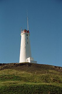
Reykjanesviti is Iceland's oldest lighthouse. It serves as a landfall light for Reykjavík and Keflavík.

Punta Carena Lighthouse is an active lighthouse, located on the island of Capri on the head of the same name, about 3 kilometres (1.9 mi) southwest of Anacapri. The lighthouse has been active since 1867; its construction began in 1862.
The High lighthouse or pillar lighthouse is one of three lighthouses in Burnham-on-Sea, Somerset, England. A Grade II listed building, it is no longer functional as a lighthouse and has been converted for use as a private dwelling.

The Low Lighthouse is one of three historic lighthouses in Burnham-on-Sea, Somerset, England, and the only one of the three which is still active. It is a Grade II listed building and stands on the foreshore. First lit in 1832, the Low Lighthouse operated in conjunction with the (onshore) High Lighthouse for 137 years. Then, in 1969 the Low Lighthouse was deactivated; but later, in 1993, the Low Lighthouse was re-established and the High Lighthouse was instead decommissioned).

Sea Hill Lighthouse, also known as Sea Hill Point Light or Little Sea Hill Light, is a lighthouse on the northwest point of Curtis Island, Gladstone Region, Queensland, Australia. Its purpose was to mark the east side of the entrance to Keppel Bay, on passage to Fitzroy River and Port Alma. The first lighthouse at the locations was constructed in 1873 or 1876, moved in the 1920s, and is now on display at the Gladstone Maritime Museum. A second lighthouse was constructed in 1895 and its state is unclear.
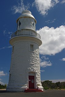
Cape Naturaliste, in the south west of Western Australia, is the site of a lighthouse which was activated in 1904.

Currie Lighthouse was built following agitation by Archibald Currie and others for a lighthouse at Currie Harbour, Currie, King Island, Australia in 1879. Planned and fabricated by Chance Brothers in Smethwick, England, it was devised as a 21-metre (69 ft)-tall square pyramidal truss iron tower with an iron cylinder centred inside, and then shipped to Tasmania to be erected. After an inactive period from 1989 to 1995, the light is now active again. The light characteristic is "Fl. 6 s", i.e. one flash every six seconds. The lightsource's focal plane is situated 46 metres (151 ft) above sea level. The adjacent keeper's house was turned into a museum in 1980.
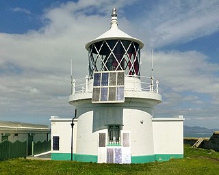
St Tudwal's Lighthouse on Saint Tudwal's Island West is active, but unstaffed. The site of the lighthouse, which marks the north end of Cardigan Bay, was purchased by Trinity House in 1876 at the sum of £111 and the next year the stone building was complete. It is 10.7 metres (35 ft) tall, with its focal plane at 46 metres (151 ft). The main white light has a range of 14 nautical miles and its red sector light has a shorter range of 10 nautical miles. It gives 1 white and red flash every 15 seconds, the intensity being 12,000 candelas.

Blåvand Lighthouse is a seacoast lighthouse in Blåvandshuk near Esbjerg, Denmark. Built in 1900 to replace an older light, the lighthouse lies on Blåvandshuk, the westernmost point in Denmark, making Blåvand Lighthouse the country's westernmost building.

Lågskär Lighthouse is an automated lighthouse located on the north side of Lågskär, one of Finland's Åland Islands in the Sea of Åland of the Baltic. It is the only striking feature on Lågskär on the generally uninhabited island.
The Minicoy Island Lighthouse, which was established on 2 February 1885 at the southern end of the Minicoy Island in the Indian state of Lakshadweep during the British regime, is 49.5 metres (162 ft) in height and has now a range of 40 nautical miles (74 km) it is built in brick masonry and has a lantern and gallery.

Miscou Island Lighthouse is an 11-metre (36 ft)-tall landfall lighthouse located on the North-Eastern tip of Miscou Island, at the entrance of the Chaleur Bay. It was built in 1856 and currently in use by the Canadian Coast Guard who owns the lighthouse, the land it is on, and also maintains it. It was built due to the shipwrecks that happened each year that could be prevented by a lighthouse. James Murray from Newcastle won the bid to construct the lighthouse. It is a federal Heritage Building that is open to the public to explore. In 2009 a parking area, washrooms, picnic area and a deck around the lighthouse was added.
Scoglio d'Africa Lighthouse is an active lighthouse located on a solitary skerry, Scoglio d'Africa, in open Tyrrhenian Sea halfway Montecristo and Pianosa.

Murano Lighthouse is an active lighthouse located in the south east part of the island of Murano in the Venetian Lagoon on the Adriatic Sea.


