
Longships Lighthouse is an active 19th-century lighthouse about 1.25 mi (2.0 km) off the coast of Land's End in Cornwall, England. It is the second lighthouse to be built on Carn Bras, the highest of the Longships islets which rises 39 feet (12 m) above high water level. In 1988 the lighthouse was automated, and the keepers withdrawn. It is now remotely monitored from the Trinity House Operations & Planning Centre in Harwich, Essex.

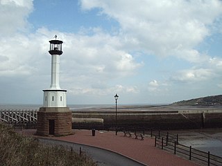
Southwold Lighthouse is a lighthouse operated by Trinity House in the centre of Southwold in Suffolk, England. It stands on the North Sea coast, acting as a warning light for shipping passing along the east coast and as a guide for vessels navigating to Southwold harbour.
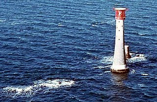
The Eddystone Lighthouse is a lighthouse on the Eddystone Rocks, 9 statute miles (14 km) south of Rame Head in Cornwall, England. The rocks are submerged below the surface of the sea and are composed of Precambrian gneiss.
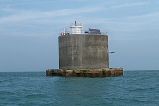
The Nab Tower is a tower originally planned for anti-submarine protection in the English Channel in World War I. It was sunk over the Nab rocks east of the Isle of Wight to replace a lightship after the war, and is a well-known landmark for sailors as it marks the deep-water eastern entry into the Solent.
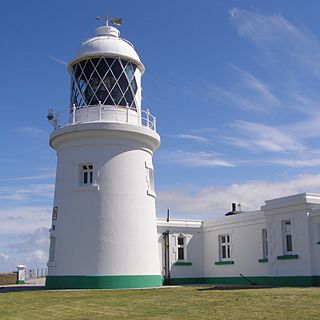
Pendeen Lighthouse, also known as Pendeen Watch is an active aid to navigation located 2 kilometres (1.2 mi) to the north of Pendeen in west Cornwall, England. It is located within the Aire Point to Carrick Du SSSI, the Cornwall Area of Outstanding Natural Beauty and the Penwith Heritage Coast. The South West Coast Path passes to the south.
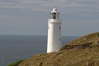
Trevose Head Lighthouse is a lighthouse on Trevose Head on the north Cornish coast at grid reference SW850766 lying to the WSW of Padstow and was sited here as there was previously no light from Land's End to Lundy and it would be visible from Cape Cornwall to Hartland Point.

Tater Du Lighthouse is Cornwall's most recently built lighthouse. The construction of the lighthouse came out of the tragedy of losing a small Spanish coaster called the Juan Ferrer on 23 October 1963, on the nearby Boscawen Point, the vessel capsized with the loss of 11 lives. After the tragedy the Newlyn and Mousehole Fishermen's Association put pressure on Trinity House for a lighthouse to be built, stating that similar tragedies could happen again. The lighthouse, built with concrete blocks, was first lit in July 1965.

Godrevy Lighthouse was built in 1858–1859 on Godrevy Island in St Ives Bay, Cornwall. Standing approximately 300 metres (980 ft) off Godrevy Head, it marks the Stones reef, which has been a hazard to shipping for centuries.

Portland Bill Lighthouse is a functioning lighthouse at Portland Bill, on the Isle of Portland, Dorset, England. The lighthouse and its boundary walls are Grade II Listed.
Maryport Lighthouse is a small lighthouse located in Maryport, Cumbria, England, formerly run by England's general lighthouse authority, Trinity House. It is a Grade II listed building.

Wolf Rock Lighthouse is on the Wolf Rock, a single rock located 18 nautical miles east of St Mary's, Isles of Scilly and 8 nautical miles southwest of Land's End, in Cornwall, England, United Kingdom. The fissures in the rock are said to produce a howling sound in gales, hence the name.

Hartland Point Lighthouse is a Grade II listed building at Hartland Point, Devon, England. The point marks the western limit of the Bristol Channel with the Atlantic Ocean continuing to the west. Trinity House, the lighthouse authority for England and Wales, have a lighthouse on the tip of the peninsula.

Berry Head Lighthouse is an active lighthouse, located at the end of Berry Head near Brixham in Devon, which has been in operation since 4 May 1906. Berry Head is reputedly the shortest lighthouse in Great Britain, but also one of the highest, being only 5 metres (16 ft) tall, but 58 metres (190 ft) above mean sea level. It was also said to be the deepest because the optic was originally turned by a weight falling down a 45 metres (148 ft) deep shaft.
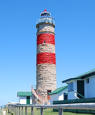
Cape Moreton Light, also listed as North Point Range Rear Light, is a heritage-listed active lighthouse located on Cape Moreton, a rocky headland located at the north eastern tip of Moreton Island, a large sand island on the eastern side of Moreton Bay, on the coast of South East Queensland, Australia. It marks the northern entrance to Moreton Bay and Brisbane and also serves as the rear light for the North Point Range. With its two distinctive red bands, it also serves as a daymark. It is the oldest lighthouse in Queensland, and the only one to be built by the New South Wales Government before the separation of Queensland, which took place in 1859. It is also the only lighthouse in Queensland to be built of stone.
The Anvil Point Lighthouse is a fully-automated lighthouse located at Durlston Country Park near Swanage in Dorset, England. It is owned by Trinity House and currently operated as two holiday cottages.

Lowestoft Lighthouse is a lighthouse operated by Trinity House located to the north of the centre of Lowestoft in the English county of Suffolk. It stands on the North Sea coast close to Ness Point, the most easterly point in the United Kingdom. It acts as a warning light for shipping passing along the east coast and is the most easterly lighthouse in the UK.

St Catherine's Lighthouse is a lighthouse located at St Catherine's Point at the southern tip of the Isle of Wight. It is one of the oldest lighthouse locations in Great Britain.
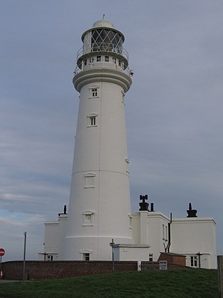
Flamborough Head Lighthouse is an active lighthouse located at Flamborough, East Riding of Yorkshire. England. Flamborough Head Lighthouse acts as a waypoint for passing deep sea vessels and coastal traffic, and marks Flamborough Head for vessels heading towards Scarborough and Bridlington.

Casquets Lighthouse is an active lighthouse located on the rocky Les Casquets, Alderney, Channel Islands.

The isle of Lundy has three lighthouses: a pair of active lights built in 1897 and a preserved older lighthouse dating from 1819.

