National Register of Historic Places listings in Bridgeport, Connecticut

Last updated
Location of Bridgeport in Fairfield County, Connecticut Map of Fairfield County, Connecticut Bridgeport Highlighted.PNG
Location of Bridgeport in Fairfield County, Connecticut

This is a list of the National Register of Historic Places listings in Bridgeport, Connecticut.

Contents

This is intended to be a complete list of the properties and districts on the National Register of Historic Places in the city of Bridgeport, Connecticut, United States. The locations of National Register properties and districts for which the latitude and longitude coordinates are included below, may be seen in an online map. [1]

There are 286 properties and districts listed on the National Register in Fairfield County, including 10 National Historic Landmarks. The city of Bridgeport is the location of 55 of these properties and districts, and one National Historic Landmark; they are listed here. Ones in Greenwich or Stamford are covered in National Register of Historic Places listings in Greenwich, Connecticut or in National Register of Historic Places listings in Stamford, Connecticut. The remainder are covered in National Register of Historic Places listings in Fairfield County, Connecticut.

Contents: Counties and municipalities in Connecticut

Fairfield (city of Bridgeport) (town of Greenwich) (city of Stamford) | Hartford (city of Hartford) (town of Southington) (town of West Hartford) (town of Windsor) | Litchfield | Middlesex (city of Middletown) | New Haven (city of New Haven) | New London | Tolland | Windham


    This National Park Service list is complete through NPS recent listings posted February 9, 2024. [2]

Map all coordinates using: OpenStreetMap

Current listings

[3] Name on the Register [4] ImageDate listed [5] Location City or townDescription
1 Barnum Museum
Barnum Museum Barnum Museum, Bridgeport.jpg
Barnum Museum
November 7, 1972
(#72001300)
820 Main St.
41°10′32″N73°11′18″W / 41.175556°N 73.188333°W / 41.175556; -73.188333 (Barnum Museum)
DowntownDesignated a National Historic Landmark in 2023.
2 Barnum/Palliser Historic District
Barnum/Palliser Historic District BridgeportCT BarnumPalisserHD 2.jpg
Barnum/Palliser Historic District
December 16, 1982
(#82000995)
Roughly bounded by Myrtle and Park Aves., Atlantic and Austin Sts. (both sides)
41°10′04″N73°11′03″W / 41.167778°N 73.184167°W / 41.167778; -73.184167 (Barnum/Palliser Historic District)
South End
3 Bassickville Historic District
Bassickville Historic District BridgeportCT BassickvilleHD HowardAve.jpg
Bassickville Historic District
September 8, 1987
(#87001511)
20-122 Bassick, 667-777 Howard, and 1521-1523 Fairview Aves., and 50-1380 State St.
41°10′16″N73°12′40″W / 41.171111°N 73.211111°W / 41.171111; -73.211111 (Bassickville Historic District)
West End - West Side
4 Beardsley Park
Beardsley Park Carouselbridgeportzoo.jpg
Beardsley Park
March 18, 1999
(#98000357)
1875 Noble Ave.
41°12′45″N73°10′56″W / 41.2125°N 73.182222°W / 41.2125; -73.182222 (Beardsley Park)
North Bridgeport
5 Berkshire No. 7
Berkshire No. 7 View of Bridge from Harbour.jpg
Berkshire No. 7
December 21, 1978
(#78002837)
Bridgeport Harbor
41°10′42″N73°11′14″W / 41.178333°N 73.187222°W / 41.178333; -73.187222 (Berkshire No. 7)
DowntownOne of three barges sunk in the harbor
6 Bikur Cholim Synagogue
Bikur Cholim Synagogue BridgeportCT BikurCholimSynagogue.jpg
Bikur Cholim Synagogue
November 27, 1995
(#95001341)
1545 Iranistan Ave.
41°10′49″N73°12′22″W / 41.180278°N 73.206111°W / 41.180278; -73.206111 (Bikur Cholim Synagogue)
West End - West Side
7 Peyton Randolph Bishop House
Peyton Randolph Bishop House BridgeportCT PeytonRandolphBishopHouse.jpg
Peyton Randolph Bishop House
August 25, 1987
(#87000803)
135 Washington Ave.
41°10′38″N73°11′54″W / 41.177222°N 73.198333°W / 41.177222; -73.198333 (Peyton Randolph Bishop House)
The Hollow
8 William D. Bishop Cottage Development Historic District
William D. Bishop Cottage Development Historic District BridgeportCT CottagePlace.jpg
William D. Bishop Cottage Development Historic District
June 28, 1982
(#82004388)
Cottage Pl. and Atlantic, Broad, Main and Whiting Sts.
41°10′05″N73°11′14″W / 41.168056°N 73.187222°W / 41.168056; -73.187222 (William D. Bishop Cottage Development Historic District)
South End
9 Black Rock Gardens Historic District
Black Rock Gardens Historic District BridgeportCT BlackRockGardensHD.jpg
Black Rock Gardens Historic District
September 26, 1990
(#90001430)
Bounded by Fairfield St., Brewster St. and Nash Ln., including Rowsley and Haddon Sts.
41°09′27″N73°13′30″W / 41.1575°N 73.225°W / 41.1575; -73.225 (Black Rock Gardens Historic District)
Black Rock
10 Black Rock Historic District
Black Rock Historic District BridgeportCT BlackRockHD QueenAnneHouses.jpg
Black Rock Historic District
March 15, 1979
(#79002658)
Roughly bounded by Black Rock Harbor, Grovers Ave., Beacon and Prescott Sts.
41°09′11″N73°13′17″W / 41.153056°N 73.221389°W / 41.153056; -73.221389 (Black Rock Historic District)
Black Rock
11 Bridgeport City Hall
Bridgeport City Hall Bridgeport City Hall postcard postmarked 1905.jpg
Bridgeport City Hall
September 19, 1977
(#77001387)
202 State St.
41°10′36″N73°11′27″W / 41.176667°N 73.190833°W / 41.176667; -73.190833 (Bridgeport City Hall)
DowntownThis listing is for the old city hall, known as McLevy Hall.
12 Bridgeport Downtown North Historic District
Bridgeport Downtown North Historic District 1941 Postcard showing Fairfield County Courthouse in Bridgeport, Connecticut.jpg
Bridgeport Downtown North Historic District
November 2, 1987
(#87001403)
Roughly bounded by Congress, Water, Fairfield Ave., Elm, Golden Hill & Chapel Sts.
41°10′49″N73°11′25″W / 41.180278°N 73.190278°W / 41.180278; -73.190278 (Bridgeport Downtown North Historic District)
Downtown
13 Bridgeport Downtown South Historic District
Bridgeport Downtown South Historic District MechanicsAndFarmersSavingsBankBuildingBridgeport.jpg
Bridgeport Downtown South Historic District
September 3, 1987
(#87001402)
Roughly bounded by Elm, Cannon, Main, Gilbert, and Broad Sts.
41°10′37″N73°11′30″W / 41.176944°N 73.191667°W / 41.176944; -73.191667 (Bridgeport Downtown South Historic District)
Downtown
14 Cassidy House
Cassidy House BridgeportCT CassidyHouse.jpg
Cassidy House
October 19, 2011
(#11000749)
691 Ellsworth St.
41°09′48″N73°13′26″W / 41.163333°N 73.223889°W / 41.163333; -73.223889 (Cassidy House)
Black RockAn 1849 Italianate farmhouse in pristine condition; originally constructed by John Plumb, it was owned by the Cassidy family for over 109 years.
15 Connecticut Railway and Lighting Company Car Barn
Connecticut Railway and Lighting Company Car Barn Pequonock River Bridge, Bridgeport (Fairfield County, Connecticut).jpg
Connecticut Railway and Lighting Company Car Barn
December 3, 1987
(#87001405)
55 Congress St.
41°10′56″N73°11′17″W / 41.182222°N 73.188056°W / 41.182222; -73.188056 (Connecticut Railway and Lighting Company Car Barn)
Downtown
16 Deacon's Point Historic District
Deacon's Point Historic District BridgeportCT DeaconsPointHD SeaviewAve.jpg
Deacon's Point Historic District
August 21, 1992
(#92001019)
Roughly bounded by Seaview Ave. and Williston, Bunnell and Deacon Sts.
41°10′59″N73°10′13″W / 41.183056°N 73.170278°W / 41.183056; -73.170278 (Deacon's Point Historic District)
East End
17 Division Street Historic District
Division Street Historic District BridgeportCT DivisionStreetHD CottageStreet.jpg
Division Street Historic District
June 3, 1982
(#82004385)
Roughly bounded by State St., Iranistan, Black Rock and West Aves.
41°10′19″N73°15′00″W / 41.171944°N 73.25°W / 41.171944; -73.25 (Division Street Historic District)
Downtown and West End - West Side
18 Eagle's Nest
Eagle's Nest BridgeportEaglesNest.jpg
Eagle's Nest
March 5, 1979
(#79002630)
282-284 Logan St.
41°10′43″N73°09′37″W / 41.178611°N 73.160278°W / 41.178611; -73.160278 (Eagle's Nest)
East EndDemolished.
19 East Bridgeport Historic District
East Bridgeport Historic District BridgeportCT EastBridgeportHD 2.jpg
East Bridgeport Historic District
April 25, 1979
(#79002659)
Roughly bounded by RR tracks, Beach, Arctic, and Knowlton Sts.
41°11′14″N73°11′09″W / 41.187222°N 73.185833°W / 41.187222; -73.185833 (East Bridgeport Historic District)
East Side
20 East Main Street Historic District
East Main Street Historic District BridgeportCT EastMainStreetHD.jpg
East Main Street Historic District
February 21, 1985
(#85000306)
Bounded by Walters and Nichols Sts. from 371-377, 741-747, 388-394 and to 744 East Main Sts.
41°10′57″N73°10′51″W / 41.1825°N 73.180833°W / 41.1825; -73.180833 (East Main Street Historic District)
East Side
21 Ein Jacob (Ayn Yacob) Synagogue
Ein Jacob (Ayn Yacob) Synagogue BridgeportCT EinJacobSynagogue.jpg
Ein Jacob (Ayn Yacob) Synagogue
November 27, 1995
(#95001342)
746 (aka 748) Connecticut Ave.
41°10′50″N73°09′51″W / 41.180556°N 73.164167°W / 41.180556; -73.164167 (Ein Jacob (Ayn Yacob) Synagogue)
East End
22 Elmer S. Dailey
Elmer S. Dailey BridgeportBarges.jpg
Elmer S. Dailey
December 21, 1978
(#78002838)
Bridgeport Harbor
41°10′43″N73°11′14″W / 41.178611°N 73.187222°W / 41.178611; -73.187222 (Elmer S. Dailey)
DowntownOne of three barges sunk in the harbor
23 Fairfield County Courthouse
Fairfield County Courthouse BridgeportCT FormerFairfieldCountyCourthouse.jpg
Fairfield County Courthouse
January 21, 1982
(#82004376)
172 Golden Hill St.
41°10′50″N73°11′28″W / 41.180556°N 73.191111°W / 41.180556; -73.191111 (Fairfield County Courthouse)
DowntownThe old courthouse, now a superior courthouse.
24 Fairfield County Jail
Fairfield County Jail OldFairfieldCountyJail.jpg
Fairfield County Jail
April 18, 1985
(#85000841)
1106 North Ave.
41°11′25″N73°12′07″W / 41.190278°N 73.201944°W / 41.190278; -73.201944 (Fairfield County Jail)
Brooklawn - St. VincentListed building demolished in 1997. [6]
25 First Baptist Church
First Baptist Church First Baptist Church in Bridgeport, Connecticut.jpg
First Baptist Church
February 22, 1990
(#90000154)
126 Washington Ave.
41°10′35″N73°11′53″W / 41.176389°N 73.198056°W / 41.176389; -73.198056 (First Baptist Church)
Downtown
26 Mary and Eliza Freeman Houses
Mary and Eliza Freeman Houses Mary and Eliza Freeman Houses 025.JPG
Mary and Eliza Freeman Houses
February 22, 1999
(#99000110)
352-4 and 358-60 Main St.
41°10′11″N73°11′12″W / 41.169722°N 73.186667°W / 41.169722; -73.186667 (Mary and Eliza Freeman Houses)
South End
27 Gateway Village Historic District
Gateway Village Historic District BridgeportCT GatewayVillageHD.jpg
Gateway Village Historic District
September 26, 1990
(#90001429)
Roughly bounded by Waterman St., Connecticut Ave. and Alanson Ave.
41°09′27″N73°13′30″W / 41.1575°N 73.225°W / 41.1575; -73.225 (Gateway Village Historic District)
East End
28 Golden Hill Historic District
Golden Hill Historic District BridgeportCityHall.jpg
Golden Hill Historic District
September 3, 1987
(#87001404)
Roughly bounded by Congress St., Lyon Terr., Elm, and Harrison Sts.
41°10′52″N73°11′36″W / 41.181111°N 73.193333°W / 41.181111; -73.193333 (Golden Hill Historic District)
Downtown
29 Hotel Beach
Hotel Beach Hotel Barnum, Bridgeport, Connecticut.jpg
Hotel Beach
December 14, 1978
(#78002839)
140 Fairfield Ave.
41°10′45″N73°11′26″W / 41.179167°N 73.190556°W / 41.179167; -73.190556 (Hotel Beach)
Downtown
30 Lakeview Village Historic District
Lakeview Village Historic District BridgeportCT LakeviewVillageHD 2.jpg
Lakeview Village Historic District
September 26, 1990
(#90001428)
Roughly bounded by Essex St., Boston Ave., Colony St., Plymouth St. and Asylum St.
41°11′50″N73°10′41″W / 41.1973°N 73.1780°W / 41.1973; -73.1780 (Lakeview Village Historic District)
North Bridgeport
31 Maplewood School
Maplewood School BridgeportCT MaplewoodSchool.jpg
Maplewood School
February 21, 1990
(#90000153)
434 Maplewood Ave.
41°10′42″N73°12′35″W / 41.178333°N 73.209722°W / 41.178333; -73.209722 (Maplewood School)
West End - West Side
32 Marina Park Historic District
Marina Park Historic District BridgeportCT MarinaParkHD 1.jpg
Marina Park Historic District
April 27, 1982
(#82004382)
Marina Park, Park and Waldemere Aves.
41°09′52″N73°11′30″W / 41.164444°N 73.191667°W / 41.164444; -73.191667 (Marina Park Historic District)
South End
33 Nathaniel Wheeler Memorial Fountain
Nathaniel Wheeler Memorial Fountain BridgeportCT WheelerFountain.jpg
Nathaniel Wheeler Memorial Fountain
April 4, 1985
(#85000706)
Park and Fairfield Aves.
41°10′29″N73°11′55″W / 41.1747°N 73.1987°W / 41.1747; -73.1987 (Nathaniel Wheeler Memorial Fountain)
West End - West Side
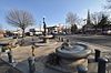
Built in 1912-1913, the fountain consists of four elements: a central bronze figure of a mermaid holding aloft a lamp and rising out of a polished granite pool and three individually ornamented polished granite watering troughs at the angles of the triangular parcel of land raised above the street. The fountain was a mid-career work of maverick American sculptor Gutzon Borglum. [7]
34 Palace and Majestic Theaters
Palace and Majestic Theaters Palace Theater balcony, Bridgeport, Connecticut.jpg
Palace and Majestic Theaters
December 14, 1979
(#79002626)
1315-1357 Main St.
41°10′56″N73°11′28″W / 41.182222°N 73.191111°W / 41.182222; -73.191111 (Palace and Majestic Theaters)
Downtown
35 Park Apartments
Park Apartments BridgeportCT ParkApartments.jpg
Park Apartments
September 26, 1990
(#90001427)
59 Rennell St.
41°09′39″N73°11′40″W / 41.160833°N 73.194444°W / 41.160833; -73.194444 (Park Apartments)
South End
36 Penfield Reef Light house
Penfield Reef Light house Penfield Reef Lighthouse Postcard 1913.jpg
Penfield Reef Light house
September 27, 1990
(#89001473)
Long Island Sound off Shoal Point
41°07′00″N73°13′18″W / 41.116667°N 73.221667°W / 41.116667; -73.221667 (Penfield Reef Light house)
Long Island Sound
37 Pequonnock River Railroad Bridge
Pequonnock River Railroad Bridge Pequonock River Bridge, Bridgeport (Fairfield County, Connecticut).jpg
Pequonnock River Railroad Bridge
June 12, 1987
(#87000843)
AMTRAK Right-of-way at Pequonnock River
41°10′59″N73°11′11″W / 41.183056°N 73.186389°W / 41.183056; -73.186389 (Pequonnock River Railroad Bridge)
Downtown and East Side
38 David Perry House
David Perry House BridgeportCT DavidPerryHouse.jpg
David Perry House
March 22, 1984
(#84000814)
531 Lafayette St.
41°10′13″N73°11′25″W / 41.170278°N 73.190278°W / 41.170278; -73.190278 (David Perry House)
Downtown
39 Priscilla Dailey
Priscilla Dailey BridgeportBarges.jpg
Priscilla Dailey
December 21, 1978
(#78002840)
Bridgeport Harbor
41°10′43″N73°11′14″W / 41.178611°N 73.187222°W / 41.178611; -73.187222 (Priscilla Dailey)
DowntownOne of three barges sunk in the harbor
40 Railroad Avenue Industrial District
Railroad Avenue Industrial District BridgeportCT RailroadAvenueViaduct.jpg
Railroad Avenue Industrial District
September 30, 1985
(#85002697)
Roughly bounded by State and Cherry Sts., Fairfield and Wordin Aves.
41°04′40″N73°12′49″W / 41.077778°N 73.213611°W / 41.077778; -73.213611 (Railroad Avenue Industrial District)
West End - West SideA cluster of old factory buildings in southern Bridgeport; some seem to have been torn down.
41 Remington City Historic District
Remington City Historic District BridgeportCT RemingtonCityHD BondStreet.jpg
Remington City Historic District
September 26, 1990
(#90001426)
Roughly, Bond, Dover, and Remington Sts. and Palisade Ave., between Stewart and Tudor Sts.
41°11′53″N73°09′56″W / 41.198056°N 73.165556°W / 41.198056; -73.165556 (Remington City Historic District)
Boston Avenue - Mill Hill
42 Remington Village Historic District
Remington Village Historic District BridgeportCT RemingtonVillageHD.jpg
Remington Village Historic District
September 26, 1990
(#90001425)
Roughly, Willow and East Aves. between Boston and Barnum Aves.
41°11′38″N73°09′36″W / 41.193889°N 73.16°W / 41.193889; -73.16 (Remington Village Historic District)
Boston Avenue - Mill Hill
43 St. John's Episcopal Church
St. John's Episcopal Church St. John's Episcopal Church in West End.JPG
St. John's Episcopal Church
August 2, 1984
(#84000820)
768 Fairfield Ave.
41°10′31″N73°11′59″W / 41.175278°N 73.199722°W / 41.175278; -73.199722 (St. John's Episcopal Church)
West End - West Side
44 Seaside Institute
Seaside Institute Seaside Institute.jpg
Seaside Institute
June 14, 1982
(#82004374)
299 Lafayette Ave.
41°10′03″N73°11′18″W / 41.1675°N 73.1883°W / 41.1675; -73.1883 (Seaside Institute)
South End
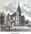
A Richardsonian Romanesque rock-faced granite, brick, brownstone and terracotta building designed by Warren R. Briggs and completed in 1887, it was originally built for the use and benefit of the female employees of the Warner Brothers corset manufacturers (now Warnaco). [8]
45 Seaside Park
Seaside Park SeasideParkBridgeport.jpg
Seaside Park
July 1, 1982
(#82004373)
Long Island Sound
41°09′41″N73°11′19″W / 41.161516°N 73.188733°W / 41.161516; -73.188733 (Seaside Park)
South End
46 Seaside Village Historic District
Seaside Village Historic District Seaside Village, Bridgeport, Connecticut.jpg
Seaside Village Historic District
September 26, 1990
(#90001424)
E. side of Iranistan Ave. between South St. and Burnham St.
41°09′59″N73°11′56″W / 41.166389°N 73.198889°W / 41.166389; -73.198889 (Seaside Village Historic District)
South End
47 Sterling Block-Bishop Arcade
Sterling Block-Bishop Arcade BridgeportCT SterlingBlockBishopArcade Inside.jpg
Sterling Block-Bishop Arcade
December 20, 1978
(#78002841)
993-1005 Main St.
41°10′41″N73°11′24″W / 41.178056°N 73.19°W / 41.178056; -73.19 (Sterling Block-Bishop Arcade)
Downtown
48 Sterling Hill Historic District
Sterling Hill Historic District BridgeportCT SterlingHillHD 1.jpg
Sterling Hill Historic District
April 2, 1992
(#92000335)
Roughly bounded by Pequonnock St., Harral Ave., James St. and Washington Ave.
41°10′53″N73°11′49″W / 41.1814°N 73.1970°W / 41.1814; -73.1970 (Sterling Hill Historic District)
The Hollow
49 Stratfield Historic District
Stratfield Historic District BridgeportCT StratfieldHD WestParishChurch.jpg
Stratfield Historic District
June 23, 1980
(#80004060)
CT 59 and U.S. 1
41°10′40″N73°12′49″W / 41.177778°N 73.213611°W / 41.177778; -73.213611 (Stratfield Historic District)
Brooklawn - St. Vincent and West End - West Side
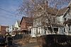
300 buildings along Clinton, Brooklawn, and Laurel Avenues that made up an elite residential district of the Edwardian era and has the original 17th century town green, Clinton Park Militia Ground, and the city's oldest cemetery, Stratfield Burying Ground, also dating back to the 17th century; this area along North Avenue is the first European settlement in what is now Bridgeport.
50 Tongue Point Lighthouse
Tongue Point Lighthouse Bridgeport Breakwater (Tongue Point) Light (Fairfield County, Connecticut).jpg
Tongue Point Lighthouse
May 29, 1990
(#89001478)
Western side of Bridgeport Harbor at Tongue Point
41°09′58″N73°10′42″W / 41.166111°N 73.178333°W / 41.166111; -73.178333 (Tongue Point Lighthouse)
South End
51 United Congregational Church
United Congregational Church Bridgeport Islamic Community Center.jpg
United Congregational Church
July 19, 1984
(#84000822)
877 Park Ave.
41°10′30″N73°12′00″W / 41.175°N 73.2°W / 41.175; -73.2 (United Congregational Church)
West End - West SideThe building was acquired from United Congregationalist Church by the local Muslim community. The architectural design is colonial revivalist and was built in the 1920s. Colonial era Ivy League college pastors are interred here.
52 United Illuminating Company Building
United Illuminating Company Building BridgeportCT UnitedIlluminatingCompanyBuilding.jpg
United Illuminating Company Building
February 21, 1985
(#85000301)
1115-1119 Broad St.
41°10′41″N73°11′31″W / 41.178056°N 73.191944°W / 41.178056; -73.191944 (United Illuminating Company Building)
Downtown
53 US Post Office-Bridgeport Main
US Post Office-Bridgeport Main BridgeportCT MainPostOffice.jpg
US Post Office-Bridgeport Main
March 17, 1986
(#86000453)
120 Middle St.
41°10′50″N73°11′20″W / 41.180556°N 73.188889°W / 41.180556; -73.188889 (US Post Office-Bridgeport Main)
Downtown
54 West End Congregation-Achavath Achim Synagogue
West End Congregation-Achavath Achim Synagogue BridgeportCT FormerAchavathAchimSynagogue.jpg
West End Congregation-Achavath Achim Synagogue
May 11, 1995
(#95000574)
725 Hancock Ave.
41°10′12″N73°12′44″W / 41.17°N 73.212222°W / 41.17; -73.212222 (West End Congregation-Achavath Achim Synagogue)
West End - West Side
55 Wilmot Apartments Historic District
Wilmot Apartments Historic District BridgeportCT WilmotApartmentsHD.jpg
Wilmot Apartments Historic District
September 26, 1990
(#90001423)
Junction of Connecticut and Wilmot Aves.
41°10′58″N73°09′44″W / 41.182778°N 73.162222°W / 41.182778; -73.162222 (Wilmot Apartments Historic District)
East End

Former listings

[3] Name on the RegisterImageDate listedDate removedLocationCity or townDescription
1 Capt. John Brooks Sr. House October 15, 1970
(#70000738)
January 23, 1979199 Pembroke St.
Bridgeport, Connecticut Dismantled in 1975

See also

Related Research Articles

<span class="mw-page-title-main">National Register of Historic Places listings in Fairfield County, Connecticut</span>

This is intended to be a complete list of the properties and districts on the National Register of Historic Places in Fairfield County, Connecticut, United States. The locations of National Register properties and districts for which the latitude and longitude coordinates are included below may be seen in an online map.

<span class="mw-page-title-main">National Register of Historic Places listings in Hartford County, Connecticut</span>

This is a list of the National Register of Historic Places designations in Hartford County, Connecticut.

<span class="mw-page-title-main">National Register of Historic Places listings in Litchfield County, Connecticut</span>

This is a list of the National Register of Historic Places listings in Litchfield County, Connecticut.

<span class="mw-page-title-main">National Register of Historic Places listings in New Haven County, Connecticut</span>

This is a list of the National Register of Historic Places listings in New Haven County, Connecticut. It is intended to be a complete list of the properties and districts on the National Register of Historic Places in New Haven County, Connecticut, United States. The locations of National Register properties and districts for which the latitude and longitude coordinates are included below, may be seen in an online map.

<span class="mw-page-title-main">National Register of Historic Places listings in Fairfax County, Virginia</span>

This is a list of the National Register of Historic Places listings in Fairfax County, Virginia.

<span class="mw-page-title-main">National Register of Historic Places listings in Bath County, Virginia</span>

This is a list of the National Register of Historic Places listings in Bath County, Virginia.

<span class="mw-page-title-main">National Register of Historic Places listings in Caroline County, Virginia</span>

This is a list of the National Register of Historic Places listings in Caroline County, Virginia.

<span class="mw-page-title-main">National Register of Historic Places listings in Charles City County, Virginia</span>

This is a list of the National Register of Historic Places listings in Charles City County, Virginia.

<span class="mw-page-title-main">National Register of Historic Places listings in Pittsylvania County, Virginia</span>

This is a list of the National Register of Historic Places listings in Pittsylvania County, Virginia.

<span class="mw-page-title-main">National Register of Historic Places listings in Gloucester County, Virginia</span>

This is a list of the National Register of Historic Places listings in Gloucester County, Virginia.

<span class="mw-page-title-main">National Register of Historic Places listings in King William County, Virginia</span>

This is a list of the National Register of Historic Places listings in King William County, Virginia.

<span class="mw-page-title-main">National Register of Historic Places listings in Prince William County, Virginia</span>

This is a list of the National Register of Historic Places listings in Prince William County, Virginia.

<span class="mw-page-title-main">National Register of Historic Places listings in Northampton County, Virginia</span>

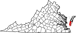
This is a list of the National Register of Historic Places listings in Northampton County, Virginia.

<span class="mw-page-title-main">National Register of Historic Places listings in Randolph County, Illinois</span>

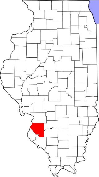
This is a list of the National Register of Historic Places listings in Randolph County, Illinois.

<span class="mw-page-title-main">National Register of Historic Places listings in St. Clair County, Illinois</span>

This is a list of the National Register of Historic Places listings in St. Clair County, Illinois.

<span class="mw-page-title-main">National Register of Historic Places listings in New Haven, Connecticut</span>

This is a list of National Register of Historic Places listings in New Haven, Connecticut.

<span class="mw-page-title-main">National Register of Historic Places listings in Logan County, Ohio</span>

This is a list of the National Register of Historic Places listings in Logan County, Ohio.

This is a list of the properties and historic districts in Stamford, Connecticut that are listed on the National Register of Historic Places. The locations of National Register properties and districts for which the latitude and longitude coordinates are included below, may be seen in an online map.

This is a list of the National Register of Historic Places listings in Greenwich, Connecticut.

<span class="mw-page-title-main">National Register of Historic Places listings in Highland County, Virginia</span>

This is a list of the National Register of Historic Places listings in Highland County, Virginia.

References

  1. The latitude and longitude information provided in this table was derived originally from the National Register Information System, which has been found to be fairly accurate for about 99% of listings. Some locations in this table may have been corrected to current GPS standards.
  2. National Park Service, United States Department of the Interior, "National Register of Historic Places: Weekly List Actions", retrieved February 9, 2024.
  3. 1 2 Numbers represent an alphabetical ordering by significant words. Various colorings, defined here, differentiate National Historic Landmarks and historic districts from other NRHP buildings, structures, sites or objects.
  4. "National Register Information System". National Register of Historic Places . National Park Service. March 13, 2009.
  5. The eight-digit number below each date is the number assigned to each location in the National Register Information System database, which can be viewed by clicking the number.
  6. "Bridgeport CC".
  7. Kate Ohno (1984). "National Register of Historic Places Inventory--Nomination Form: Nathaniel Wheeler Memorial Fountain" (pdf). National Park Service. Retrieved 2010-08-15. and 5 accompanying photographs.
  8. Dale S. Plummer (September 8, 1980). "National Register of Historic Places Inventory-Nomination: Seaside Institute" (pdf). National Park Service.