National Register of Historic Places listings in Tolland County, Connecticut

Last updated

Location of Tolland County in Connecticut Map of Connecticut highlighting Tolland County.svg
Location of Tolland County in Connecticut

This is a list of the National Register of Historic Places listings in Tolland County, Connecticut.

Contents

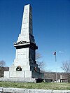
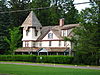
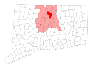
This is intended to be a complete list of the properties and districts on the National Register of Historic Places in Tolland County, Connecticut, United States. The locations of National Register properties and districts for which the latitude and longitude coordinates are included below, may be seen in an online map. [1]

There are 51 properties and districts listed on the National Register in the county.

Contents: Counties and municipalities in Connecticut

Fairfield (city of Bridgeport) (town of Greenwich) (city of Stamford) | Hartford (city of Hartford) (town of Southington) (town of West Hartford) (town of Windsor) | Litchfield | Middlesex (city of Middletown) | New Haven (city of New Haven) | New London | Tolland | Windham


    This National Park Service list is complete through NPS recent listings posted December 15, 2023. [2]

Map all coordinates using: OpenStreetMap

Current listings

[3] Name on the Register [4] ImageDate listed [5] Location City or townDescription
1 Andover Center Historic District
Andover Center Historic District Andover Historical Society, Andover, Connecticut.jpg
Andover Center Historic District
April 18, 2003
(#03000236)
Roughly along Hebron Rd., Boston Hill Rd., and U.S. Route 6
41°44′03″N72°22′30″W / 41.734167°N 72.375°W / 41.734167; -72.375 (Andover Center Historic District)
Andover
2 Bolton Green Historic District
Bolton Green Historic District Bolton Green Historic District.JPG
Bolton Green Historic District
April 12, 2001
(#01000357)
Roughly the Green, 219, 220, 222, 228, 233, 266 Bolton Center Rd. and 3 Hebron Rd.
41°46′20″N72°25′42″W / 41.772222°N 72.428333°W / 41.772222; -72.428333 (Bolton Green Historic District)
Bolton
3 Brigham's Tavern
Brigham's Tavern Brighams Tavern, Coventry CT.jpg
Brigham's Tavern
March 25, 1982
(#82004383)
12 Boston Turnpike
41°47′58″N72°18′53″W / 41.7994°N 72.3147°W / 41.7994; -72.3147 (Brigham's Tavern)
Coventry
4 John Cady House
John Cady House TollandCT JohnCadyHouse.jpg
John Cady House
April 12, 1982
(#82004390)
484 Mile Hill Rd.
41°49′51″N72°24′00″W / 41.8308°N 72.4°W / 41.8308; -72.4 (John Cady House)
Tolland
5 Capron-Phillips House
Capron-Phillips House Capron-Phillips House, Coventry CT.jpg
Capron-Phillips House
April 27, 1982
(#82004384)
1129 Main St.
41°46′00″N72°17′54″W / 41.7667°N 72.2983°W / 41.7667; -72.2983 (Capron-Phillips House)
Coventry
6 Captain Nathan Hale Monument
Captain Nathan Hale Monument Nathan Hale Memorial, Coventry CT.jpg
Captain Nathan Hale Monument
January 28, 2002
(#01001531)
120 Lake St.
41°46′04″N72°18′24″W / 41.767778°N 72.306667°W / 41.767778; -72.306667 (Captain Nathan Hale Monument)
Coventry
7 Columbia Green Historic District
Columbia Green Historic District Columbia Congregational Church, Columbia CT.jpg
Columbia Green Historic District
December 6, 1990
(#90001759)
Along CT 87 at its junction with CT 66
41°42′05″N72°18′10″W / 41.701389°N 72.302778°W / 41.701389; -72.302778 (Columbia Green Historic District)
Columbia
8 Jared Cone House
Jared Cone House Jared Cone House.JPG
Jared Cone House
February 21, 1990
(#90000155)
25 Hebron Rd.
41°45′58″N72°26′02″W / 41.766111°N 72.433889°W / 41.766111; -72.433889 (Jared Cone House)
Bolton
9 Coventry Glass Factory Historic District
Coventry Glass Factory Historic District House at the corner of US Route 44 and North River Road, Coventry CT.jpg
Coventry Glass Factory Historic District
August 27, 1987
(#87000806)
U.S. Route 44 and N. River Rd.
41°47′56″N72°21′02″W / 41.798889°N 72.350556°W / 41.798889; -72.350556 (Coventry Glass Factory Historic District)
Coventry
10 Eldredge Mills Archeological District
Eldredge Mills Archeological District WillingtonCT EldredgeMillHeadRace.jpg
Eldredge Mills Archeological District
October 20, 2000
(#00000938)
Address Restricted
Willington
11 Ellington Center Historic District
Ellington Center Historic District Town Green, Ellington CT.jpg
Ellington Center Historic District
November 15, 1990
(#90001754)
Roughly Maple St. from Berr Ave. to just west of the High School and Main St. from Jobs Hill Rd. to East Green
41°54′15″N72°28′17″W / 41.904167°N 72.471389°W / 41.904167; -72.471389 (Ellington Center Historic District)
Ellington
12 Farwell Barn
Farwell Barn StorrsCT JacobsonBarn.jpg
Farwell Barn
January 26, 2001
(#00001649)
Horsebarn Hill Rd.
41°49′08″N72°14′57″W / 41.818889°N 72.249167°W / 41.818889; -72.249167 (Farwell Barn)
Mansfield Also known as the Jacobson Barn; on the UConn campus
13 Fifth Camp of Rochambeau's Infantry
Fifth Camp of Rochambeau's Infantry March route of Rochambeaus army original.JPG
Fifth Camp of Rochambeau's Infantry
April 30, 2001
(#01000446)
Bolton Heritage Farm [6]
41°46′14″N72°25′36″W / 41.77056°N 72.426749°W / 41.77056; -72.426749 (Fifth Camp of Rochambeau's Infantry)
Bolton
14 Florence Mill
Florence Mill Florence Mill, Rockville (Vernon) CT.jpg
Florence Mill
July 18, 1978
(#78002858)
121 W. Main St.
41°51′52″N72°27′15″W / 41.864444°N 72.454167°W / 41.864444; -72.454167 (Florence Mill)
Vernon
15 Gurleyville Historic District
Gurleyville Historic District GURLEYVILLE HISTORIC DISTRICT.jpg
Gurleyville Historic District
December 30, 1975
(#75001933)
North of Mansfield Center off CT 195 at the junction of Gurleyville and Chaffeeville Rds.
41°48′47″N72°13′21″W / 41.813056°N 72.2225°W / 41.813056; -72.2225 (Gurleyville Historic District)
Mansfield
16 Nathan Hale Homestead
Nathan Hale Homestead Nathan Hale Homestead.JPG
Nathan Hale Homestead
October 22, 1970
(#70000698)
South St.
41°45′50″N72°20′47″W / 41.763889°N 72.346389°W / 41.763889; -72.346389 (Nathan Hale Homestead)
Coventry
17 Hebron Center Historic District
Hebron Center Historic District Old Town Hall, Hebron CT.jpg
Hebron Center Historic District
July 30, 1993
(#93000649)
Church, Gilead, Main, Wall, and West Sts. and Marjorie Cir.
41°39′26″N72°22′08″W / 41.657222°N 72.368889°W / 41.657222; -72.368889 (Hebron Center Historic District)
Hebron
18 Knesseth Israel Synagogue
Knesseth Israel Synagogue Congregation Knesseth Israel.JPG
Knesseth Israel Synagogue
July 21, 1995
(#95000862)
236 Pinney St.
41°53′50″N72°28′48″W / 41.897222°N 72.48°W / 41.897222; -72.48 (Knesseth Israel Synagogue)
Ellington
19 Loomis-Pomeroy House
Loomis-Pomeroy House CoventryCT LoomisPomeroyHouse.jpg
Loomis-Pomeroy House
April 26, 1994
(#94000370)
1747 Boston Tpk.
41°47′52″N72°22′35″W / 41.797778°N 72.376389°W / 41.797778; -72.376389 (Loomis-Pomeroy House)
Coventry
20 Mansfield Center Cemetery
Mansfield Center Cemetery Mansfield Center Cemetery.jpg
Mansfield Center Cemetery
July 24, 1992
(#92000905)
Junction of Storrs and Cemetery Rds.
41°45′43″N72°11′46″W / 41.761944°N 72.196111°W / 41.761944; -72.196111 (Mansfield Center Cemetery)
Mansfield
21 Mansfield Center Historic District
Mansfield Center Historic District First Church of Christ, Mansfield CT.jpg
Mansfield Center Historic District
February 23, 1972
(#72001337)
Storrs Rd.
41°46′37″N72°11′55″W / 41.776944°N 72.198611°W / 41.776944; -72.198611 (Mansfield Center Historic District)
Mansfield
22 Mansfield Hollow Dam
Mansfield Hollow Dam USACE Mansfield Hollow Lake.jpg
Mansfield Hollow Dam
April 12, 2009
(#03000194)
141 Mansfield Hollow Rd.
41°45′20″N72°10′54″W / 41.75569°N 72.18163°W / 41.75569; -72.18163 (Mansfield Hollow Dam)
Mansfield and Windham Extends into Windham County
23 Mansfield Hollow Historic District
Mansfield Hollow Historic District Kirbys Mill, Mansfield CT.jpg
Mansfield Hollow Historic District
May 21, 1979
(#79002667)
86-127 Mansfield Hollow Rd.
41°45′25″N72°11′09″W / 41.756944°N 72.185833°W / 41.756944; -72.185833 (Mansfield Hollow Historic District)
Mansfield
24 Mansfield Training School and Hospital
Mansfield Training School and Hospital The Knight Hospital.jpg
Mansfield Training School and Hospital
December 22, 1987
(#87001513)
Junction of CT 32 and US 44
41°48′22″N72°18′16″W / 41.806111°N 72.304444°W / 41.806111; -72.304444 (Mansfield Training School and Hospital)
Mansfield
25 March Route of Rochambeau's Army: Bailey Road
March Route of Rochambeau's Army: Bailey Road BoltonCT RochambeauRoute BaileyRoad.jpg
March Route of Rochambeau's Army: Bailey Road
January 8, 2003
(#02001677)
Bailey Rd.
41°45′44″N72°24′49″W / 41.762222°N 72.413611°W / 41.762222; -72.413611 (March Route of Rochambeau's Army: Bailey Road)
Bolton
26 March Route of Rochambeau's Army: Hutchinson Road
March Route of Rochambeau's Army: Hutchinson Road CoventryCT HutchinsonRoad.jpg
March Route of Rochambeau's Army: Hutchinson Road
May 6, 2002
(#02000425)
Hutchinson Road from its junction with Hendee Rd. southward to its end
41°45′26″N72°23′59″W / 41.757361°N 72.399722°W / 41.757361; -72.399722 (March Route of Rochambeau's Army: Hutchinson Road)
Andover
27 Minterburn Mill
Minterburn Mill Former Roosevelt Mill, Rockville (Vernon) CT.jpg
Minterburn Mill
February 16, 1984
(#84001171)
215 E. Main St.
41°52′04″N72°25′59″W / 41.867778°N 72.433056°W / 41.867778; -72.433056 (Minterburn Mill)
Vernon
28 Old Rockville High School and East School
Old Rockville High School and East School Rockville Board of Education, Vernon CT.jpg
Old Rockville High School and East School
April 27, 1981
(#81000614)
School and Park Sts.
41°52′07″N72°26′53″W / 41.868611°N 72.448056°W / 41.868611; -72.448056 (Old Rockville High School and East School)
Vernon Now the Board of Education building
29 Oliver White Tavern
Oliver White Tavern Oliver White Tavern.JPG
Oliver White Tavern
May 6, 2002
(#02000422)
2 Brandy St.
41°46′11″N72°25′29″W / 41.769722°N 72.424722°W / 41.769722; -72.424722 (Oliver White Tavern)
Bolton
30 Parker-Hutchinson Farm
Parker-Hutchinson Farm CoventryCT ParkerHutchinsonFarm.jpg
Parker-Hutchinson Farm
April 29, 1982
(#82004386)
Parker Bridge Rd.
41°44′27″N72°19′23″W / 41.740833°N 72.323056°W / 41.740833; -72.323056 (Parker-Hutchinson Farm)
Coventry
31 Augustus Post House
Augustus Post House Augustus Post House, Hebron CT.jpg
Augustus Post House
June 28, 1982
(#82004387)
4 Main St.
41°39′28″N72°21′59″W / 41.657778°N 72.366389°W / 41.657778; -72.366389 (Augustus Post House)
Hebron
32 Rockville Historic District
Rockville Historic District The Tower on Fox Hill, Vernon Connecticut USA.JPG
Rockville Historic District
September 13, 1984
(#84001173)
Roughly bounded by Snipsic St., Davis Ave., and West and South Sts.
41°51′51″N72°27′04″W / 41.864167°N 72.451111°W / 41.864167; -72.451111 (Rockville Historic District)
Vernon
33 Saxony Mill
Saxony Mill SaxonyMillAbout1895.png
Saxony Mill
November 10, 1983
(#83003592)
66 West St.
41°51′58″N72°27′56″W / 41.866111°N 72.465556°W / 41.866111; -72.465556 (Saxony Mill)
Vernon Destroyed by fire in 1994.
34 Sharpe's Trout Hatchery Site
Sharpe's Trout Hatchery Site VernonCT ValleyFallsHatcheryAreaBrook.jpg
Sharpe's Trout Hatchery Site
March 31, 1997
(#97000274)
Valley Falls Park [7]
41°49′16″N72°26′38″W / 41.821°N 72.444°W / 41.821; -72.444 (Sharpe's Trout Hatchery Site)
Vernon
35 Somers Historic District
Somers Historic District Claudius Pease House, Somers CT.jpg
Somers Historic District
September 23, 1982
(#82004389)
Main and Battle Sts., Bugbee Lane, and Springfield Rd.
41°59′07″N72°26′48″W / 41.985278°N 72.446667°W / 41.985278; -72.446667 (Somers Historic District)
Somers
36 Somersville Historic District
Somersville Historic District Former Billings Mill, Somersville CT.jpg
Somersville Historic District
April 13, 1995
(#95000401)
Roughly along Main, Maple and School Sts., Pinney and Shaker Rd. and Quality Ave.
41°58′52″N72°29′24″W / 41.981111°N 72.49°W / 41.981111; -72.49 (Somersville Historic District)
Somers
37 South Coventry Historic District
South Coventry Historic District Bidwell Tavern, Coventry CT.jpg
South Coventry Historic District
May 6, 1991
(#91000482)
Roughly Main St. and adjacent streets from Armstrong Rd. to Lake St. and Lake from High St. to Main
41°46′05″N72°18′07″W / 41.768°N 72.302°W / 41.768; -72.302 (South Coventry Historic District)
Coventry
38 South Willington Historic District
South Willington Historic District WillingtonCT SouthWillingtonHD 4.jpg
South Willington Historic District
November 30, 2017
(#100001860)
River Rd. roughly Battye Rd. to Fisher Hill Rd.; Pinney Hill Rd., Village & Center Sts.
41°51′07″N72°18′06″W / 41.851899°N 72.301543°W / 41.851899; -72.301543 (South Willington Historic District)
Willington
39 Elias Sprague House
Elias Sprague House CoventryCT EliasSpragueHouse2.jpg
Elias Sprague House
November 2, 1987
(#87001910)
2187 South St.
41°45′56″N72°20′29″W / 41.765556°N 72.341389°W / 41.765556; -72.341389 (Elias Sprague House)
Coventry
40 Spring Hill Historic District
Spring Hill Historic District Altnaveigh Inn, Mansfield CT.jpg
Spring Hill Historic District
October 10, 1979
(#08000500)
Roughly along Storrs Rd.
41°47′23″N72°13′39″W / 41.789722°N 72.227500°W / 41.789722; -72.227500 (Spring Hill Historic District)
Mansfield
41 Stafford Hollow Historic District
Stafford Hollow Historic District StaffordCT StaffordHollowHD 4.jpg
Stafford Hollow Historic District
October 15, 1987
(#87002032)
Roughly parts of Leonard, Murphy, Old Monson, Orcuttville, and Patten Rds.
41°59′08″N72°17′26″W / 41.985556°N 72.290556°W / 41.985556; -72.290556 (Stafford Hollow Historic District)
Stafford
42 Strong House
Strong House Strong House.JPG
Strong House
January 15, 1988
(#87001906)
2382 South St.
41°45′58″N72°20′55″W / 41.766111°N 72.348611°W / 41.766111; -72.348611 (Strong House)
Coventry
43 Talcottville Historic District
Talcottville Historic District VernonCT TalcottvilleWarburtonHouse.jpg
Talcottville Historic District
January 5, 1989
(#88002959)
13-44 Elm Hill Rd. and 11-132 Main St.
41°49′12″N72°29′51″W / 41.82°N 72.4975°W / 41.82; -72.4975 (Talcottville Historic District)
Vernon
44 Tolland County Courthouse
Tolland County Courthouse Former Tolland County Courthouse, Tolland, Connecticut.jpg
Tolland County Courthouse
September 17, 1977
(#09000084)
53 Tolland Green
41°52′18″N72°22′11″W / 41.871667°N 72.369722°W / 41.871667; -72.369722 (Tolland County Courthouse)
Tolland
45 Tolland Green Historic District
Tolland Green Historic District HicksStearnsMuseumTollandCT gobeirne.JPG
Tolland Green Historic District
August 1, 1997
(#97000832)
Roughly along Old Post, Tolland Stage, and Cider Mill Rds.
41°52′11″N72°22′36″W / 41.8697°N 72.3767°W / 41.8697; -72.3767 (Tolland Green Historic District)
Tolland
46 Union Green Historic District
Union Green Historic District UnionCT TownGreen.jpg
Union Green Historic District
July 19, 1990
(#90001099)
Roughly the area north of the junction of Buckley Highway and Cemetery Rd. to the junction of Kinney Hollow and Town Hall Rds.
41°59′23″N72°09′36″W / 41.9897°N 72.16°W / 41.9897; -72.16 (Union Green Historic District)
Union
47 University of Connecticut Historic District-Connecticut Agricultural School
University of Connecticut Historic District-Connecticut Agricultural School Wilbur Cross Library, UConn, Storrs CT.jpg
University of Connecticut Historic District-Connecticut Agricultural School
January 31, 1989
(#88003202)
Roughly CT 195/Storrs Rd. at Eagleville Rd.
41°48′29″N72°15′03″W / 41.8081°N 72.2508°W / 41.8081; -72.2508 (University of Connecticut Historic District-Connecticut Agricultural School)
Mansfield
48 Valley Falls Cotton Mill Site
Valley Falls Cotton Mill Site VernonCT ValleyFallsDam.jpg
Valley Falls Cotton Mill Site
March 28, 1997
(#97000276)
Valley Falls Park [7] [8]
41°49′16″N72°26′37″W / 41.821015°N 72.443495°W / 41.821015; -72.443495 (Valley Falls Cotton Mill Site)
Vernon
49 White's Tavern
White's Tavern Whites Tavern.JPG
White's Tavern
July 26, 1991
(#91000947)
131 U.S. Route 6
41°45′12″N72°23′51″W / 41.7533°N 72.3975°W / 41.7533; -72.3975 (White's Tavern)
Andover
50 Eleazer Williams House
Eleazer Williams House ManchesterCT EleazarWilliamsHouse.jpg
Eleazer Williams House
March 11, 1971
(#71000910)
Storrs Rd. (Route 195)
41°46′01″N72°11′58″W / 41.7669°N 72.1994°W / 41.7669; -72.1994 (Eleazer Williams House)
Mansfield
51 Willington Common Historic District
Willington Common Historic District WillingtonCT Meetinghouse.jpg
Willington Common Historic District
December 18, 1990
(#90001911)
Properties around Willington Common and east on the Tolland Turnpike past Old Farms Rd.
41°52′31″N72°15′52″W / 41.8753°N 72.2644°W / 41.8753; -72.2644 (Willington Common Historic District)
Willington

See also

Related Research Articles

<span class="mw-page-title-main">National Register of Historic Places listings in Hartford County, Connecticut</span>

This is a list of the National Register of Historic Places designations in Hartford County, Connecticut.

<span class="mw-page-title-main">National Register of Historic Places listings in New Haven County, Connecticut</span>

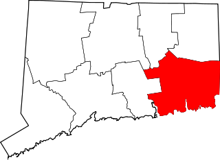
This is a list of the National Register of Historic Places listings in New Haven County, Connecticut. It is intended to be a complete list of the properties and districts on the National Register of Historic Places in New Haven County, Connecticut, United States. The locations of National Register properties and districts for which the latitude and longitude coordinates are included below, may be seen in an online map.

<span class="mw-page-title-main">National Register of Historic Places listings in New London County, Connecticut</span>

This is a list of the National Register of Historic Places listings in New London County, Connecticut.

<span class="mw-page-title-main">National Register of Historic Places listings in Windham County, Connecticut</span>

This is a list of the National Register of Historic Places listings in Windham County, Connecticut.

<span class="mw-page-title-main">National Register of Historic Places listings in Burlington County, New Jersey</span>

List of the National Register of Historic Places listings in Burlington County, New Jersey

<span class="mw-page-title-main">National Register of Historic Places listings in Knox County, Ohio</span>

This is a list of the National Register of Historic Places listings in Knox County, Ohio.

<span class="mw-page-title-main">National Register of Historic Places listings in Hartford, Connecticut</span>

This is a list of properties on the National Register of Historic Places in Hartford, Connecticut.

<span class="mw-page-title-main">National Register of Historic Places listings in Fairfax County, Virginia</span>

This is a list of the National Register of Historic Places listings in Fairfax County, Virginia.

<span class="mw-page-title-main">National Register of Historic Places listings in Charles City County, Virginia</span>

This is a list of the National Register of Historic Places listings in Charles City County, Virginia.

<span class="mw-page-title-main">National Register of Historic Places listings in Wood County, West Virginia</span>

This is a list of the National Register of Historic Places listings in Wood County, West Virginia.

<span class="mw-page-title-main">National Register of Historic Places listings in Prince William County, Virginia</span>

This is a list of the National Register of Historic Places listings in Prince William County, Virginia.

<span class="mw-page-title-main">National Register of Historic Places listings in Allamakee County, Iowa</span>

This is a list of the National Register of Historic Places listings in Allamakee County, Iowa.

<span class="mw-page-title-main">National Register of Historic Places listings in Northampton County, Virginia</span>

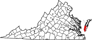
This is a list of the National Register of Historic Places listings in Northampton County, Virginia.

<span class="mw-page-title-main">National Register of Historic Places listings in Perry County, Ohio</span>

This is a list of the National Register of Historic Places listings in Perry County, Ohio.

<span class="mw-page-title-main">National Register of Historic Places listings in Bridgeport, Connecticut</span>

This is a list of the National Register of Historic Places listings in Bridgeport, Connecticut.

<span class="mw-page-title-main">National Register of Historic Places listings in Vernon Parish, Louisiana</span>

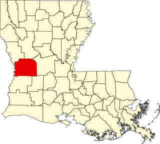
This is a list of the National Register of Historic Places listings in Vernon Parish, Louisiana.

<span class="mw-page-title-main">National Register of Historic Places listings in Callaway County, Missouri</span>

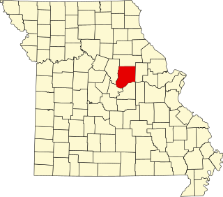
This is a list of the National Register of Historic Places listings in Callaway County, Missouri.

<span class="mw-page-title-main">National Register of Historic Places listings in West Hartford, Connecticut</span>

This is a list of the National Register of Historic Places listings in West Hartford, Connecticut.

<span class="mw-page-title-main">National Register of Historic Places listings in Windsor, Connecticut</span>

This is a list of the National Register of Historic Places listings in Windsor, Connecticut.

<span class="mw-page-title-main">National Register of Historic Places listings in Vernon County, Missouri</span>

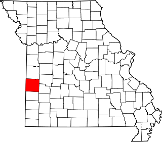
This is a list of the National Register of Historic Places listings in Vernon County, Missouri.

References

  1. The latitude and longitude information provided in this table was derived originally from the National Register Information System, which has been found to be fairly accurate for about 99% of listings. Some locations in this table may have been corrected to current GPS standards.
  2. National Park Service, United States Department of the Interior, "National Register of Historic Places: Weekly List Actions", retrieved December 15, 2023.
  3. Numbers represent an alphabetical ordering by significant words. Various colorings, defined here, differentiate National Historic Landmarks and historic districts from other NRHP buildings, structures, sites or objects.
  4. "National Register Information System". National Register of Historic Places . National Park Service. March 13, 2009.
  5. The eight-digit number below each date is the number assigned to each location in the National Register Information System database, which can be viewed by clicking the number.
  6. "Bolton Heritage Farm Environmental Review" (PDF). State of Connecticut. Archived from the original (PDF) on 2013-10-12. Retrieved 2013-10-05.
  7. 1 2 "History of Valley Falls Park" (PDF). The Tankerhoosen. Retrieved 2013-10-05.
  8. "Vernon Trails Brochure" (PDF). Town of Vernon. Retrieved 2013-10-05.