This article needs additional citations for verification .(December 2012) |
In Nepal, some customary units of measurement are still used, although the metric system has been the official standard since 1968. [1]
This article needs additional citations for verification .(December 2012) |
In Nepal, some customary units of measurement are still used, although the metric system has been the official standard since 1968. [1]
The kos (kosh, krosh, koss) is a very ancient measure of distance, measuring about 2.25 miles or 3.7 km. [2]
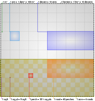
The precise land measurement conversions as per Nepal standard are as follows:
| Units | khetmuri | bigha | kattha | dhur | ropani | aana | paisa | dam | sq.feet | sq.meter |
|---|---|---|---|---|---|---|---|---|---|---|
| khetmuri | 1 | 1.877914952 | 37.55829904 | 751.1659808 | 25 | 400 | 1600 | 6400 | 136900 | 12718.42618 |
| bigha | 0.532505478 | 1 | 20 | 400 | 13.31263696 | 213.0021914 | 852.0087655 | 3408.035062 | 72900 | 6772.631616 |
| kattha | 0.026625274 | 0.05 | 1 | 20 | 0.665631848 | 10.65010957 | 42.60043828 | 170.4017531 | 3645 | 338.6315808 |
| dhur | 0.001331264 | 0.0025 | 0.05 | 1 | 0.033281592 | 0.532505478 | 2.130021914 | 8.520087655 | 182.25 | 16.93157904 |
| ropani | 0.04 | 0.075116598 | 1.502331962 | 30.04663923 | 1 | 16 | 64 | 256 | 5476 | 508.737047 |
| aana | 0.0025 | 0.004694787 | 0.093895748 | 1.877914952 | 0.0625 | 1 | 4 | 16 | 342.25 | 31.79606544 |
| paisa | 0.000625 | 0.001173697 | 0.023473937 | 0.469478738 | 0.015625 | 0.25 | 1 | 4 | 85.5625 | 7.94901636 |
| dam | 0.00015625 | 0.000293424 | 0.005868484 | 0.117369684 | 0.00390625 | 0.0625 | 0.25 | 1 | 21.390625 | 1.98725409 |
| sq. feet | 7.3046E-06 | 1.37174E-05 | 0.000274348 | 0.005486968 | 0.000182615 | 0.002921841 | 0.011687363 | 0.046749452 | 1 | 0.09290304 |
| sq. meter | 7.86261E-05 | 0.000147653 | 0.002953062 | 0.059061237 | 0.001965652 | 0.031450432 | 0.125801729 | 0.503206915 | 10.76391042 | 1 |
In a nutshell, The following is a partial list of everyday units used to calculate land area in Nepal. [3] [4]
The units of measurement of area of land depends on the part of the country where they are being used, with the Bigha-Katha-Dhur measurements common in the Terai region while the Ropani-Aana measurements are common in hilly and mountainous regions.
In the Terai region, the southern parts of Nepal, the customary units are those used elsewhere in South Asia:
A different system is used in hilly regions:
Conversions

Nepal measures about 880 kilometers (547 mi) along its Himalayan axis by 150 to 250 kilometers across. It has an area of 147,516 km2 (56,956 sq mi).
The square foot is an imperial unit and U.S. customary unit of area, used mainly in the United States and partially in Canada, the United Kingdom, Bangladesh, India, Nepal, Pakistan, Ghana, Liberia, Malaysia, Myanmar, Singapore and Hong Kong. It is defined as the area of a square with sides of 1 foot.

The Terai or Tarai is to a lowland region in parts of northern India and southern Nepal that lies to the south of the outer foothills of the Himalayas, the Sivalik Hills and north of the Indo-Gangetic Plain. This lowland belt is characterised by tall grasslands, scrub savannah, sal forests and clay rich swamps. In North India, the Terai spreads from the Yamuna River eastward across Haryana, Uttarakhand, Uttar Pradesh, Bihar and West Bengal. The Terai is part of the Terai-Duar savanna and grasslands ecoregion. Nepal's Terai stretches over 33,998.8 km2 (13,127.0 sq mi), about 23.1% of Nepal's land area, and lies at an elevation of between 67 and 300 m. The region comprises more than 50 wetlands. North of the Terai rises the Bhabar, a narrow but continuous belt of forest about 8–12 km (5.0–7.5 mi) wide.
Traditional Swedish units of measurement were standardized by law in 1665, prior to which they only existed as a number of related but differing local variants. The system was slightly revised in 1735. In 1855, a decimal reform was instituted that defined a new Swedish inch as 1⁄10 Swedish foot. Up to the middle of the 19th century, there was a law allowing the imposition of the death penalty for falsifying weights or measures. Sweden adopted the metric system in 1889, after a decision by the parliament in 1875 and a ten-year transition period from 1879. Only the Swedish mile, mil, has been preserved, now measuring 10 kilometres.

Jhapa District is a district of Koshi Province in eastern Nepal named after a Rajbanshi Surjapuri language word "Jhapa", meaning "to cover" (verb). The 2021 Nepal Census, puts the total population of the district at 994,090. The total area of the district is 1,606 square kilometres.
The bigha or beegah is a traditional unit of measurement of area of a land, commonly used in northern & eastern India, Bangladesh and Nepal. There is no "standard" size of bigha and it varies considerably from place to place.
Choapha Supatpha also Swargadeo Gadadhar Singha, was the twenty-ninth king of Ahom kingdom, who reigned from 1681 to 1696. He established the rule of Tungkhungia royal house of Ahom kings, whose descendants continued to rule till the climactic end of the Ahom kingdom in 1826. He was earlier known as Gadapani Konwar and was a son of Gobar raja, a descendant of Suhungmung, and who had become king for twenty days. Gadadhar Singha stabilized the Ahom kingdom, which was going through a long decade of political turmoil and instability. This period saw the ruthless power grab of Debera Borbarua and Laluksola Borphukan's abandonment of Guwahati to the hands of Mughals and oppression via Sulikphaa alias Lora Roja.
Katha or Biswa is a unit of area mostly used for land measurement in India, Nepal, and Bangladesh. After metrication in the mid-20th century by these countries, the unit became officially obsolete. But this unit is still in use in much of Bangladesh, Northern India, Eastern India and Nepal. The measurement of katha varies significantly from place to place.
The TinBigha Corridor is a strip of land belonging to India on the West Bengal–Bangladesh border which, in September 2011, was leased to Bangladesh so the country could access its Dahagram–Angarpota enclave from the mainland. The enclave remains the only one still in existence after the 2015 resolution of the India–Bangladesh enclaves issue. It is situated in the town of Patgram Upazila.
The kos, also spelled coss, koss, kosh, krosh, and krosha, is a unit of measurement which is derived from a Sanskrit term, क्रोश krośa, which means a 'call', as the unit was supposed to represent the distance at which another human could be heard. It is an ancient Indian subcontinental standard unit of distance, in use since at least 4 BCE. According to the Arthashastra, a krośa or kos is about 3,000 metres (9,800 ft).
A dessiatin or desyatina is an archaic, rudimentary land measurement used in tsarist Russia. A dessiatin is equal to 2,400 square sazhens and is approximately equivalent to 2.702 English acres or, precisely, 10,925.397 504 square metres.
The Inner Terai Valleys of Nepal comprise several elongated river valleys in the southern lowland Terai part of the country. These tropical valleys are enclosed by the Himalayan foothills, viz the Mahabharat Range and the Sivalik Hills farther south.
Hardauna is a village in the sub-metropolitan municipality of Maharajganj in the Kapilvastu District of the Lumbini Province. The village is in a terai region in southern Nepal. It is on the Banganga, a river which arises on the southern slopes of the Sivalik Hills and flows across the Terai, reaching into Uttar Pradesh state in India.
The candy or candee, also known as the maunee, was a traditional South Asian unit of mass, equal to 20 maunds and roughly equivalent to 500 pounds avoirdupois (227 kilograms). It was most used in southern India, to the south of Akbar's empire, but has been recorded elsewhere in South Asia. In Marathi, the same word was also used for a unit of area of 120 bighas, and it is also recorded as a unit of dry volume.
The measurement of land in Punjab, India is an important aspect of agriculture and land management in the region. Punjab has a unique system of measuring land, typically done in units of bigha and acre. The measurements can vary slightly depending on the specific region and local customs.
In Guatemala the metric system is official but it uses a mixture of U.S., metric and Spanish customary units.

Koshi Province is the autonomous easternmost province adopted on 20 September 2015 by Constitution of Nepal. The province is rich in natural resources, tourist attractions, recreational activities, and natural beauty. The province covers an area of 25,905 km2 (10,002 sq mi), about 17.5% of the country's total area. With the industrial city of Biratnagar as its capital, the province includes major eastern towns of Birtamod, Sundar Haraincha, Damak, Dharan, Itahari, Triyuga Municipality and Mechinagar, and the Mount Everest, Kangchenjunga and Ama Dablam. Koshi River, the largest river of the nation, forms the province's western boundary. Under the First-past-the-post voting system issued by the Constituency Delimitation Commission, Nepal, the province hosts 28 parliamentary seats and 56 provincial assembly seats.
Bardagoriya is a rural municipality in Kailali District of Nepal. Bardagoriya Rural Municipality lies 65 km east of Dhangadhi and 605 km west of the capital, Kathmandu. It is surrounded by Ghodaghodi Municipality to the west, Lamki Chuha Municipality to the east, Joshipur Rural Municipality to the south and Mohanyal to the north. Bauniya Bazar is its largest market.
The Tinkathia System or Teen Kathia System, was an economic policy enforced by the East India Company in India. It was practiced largely in Eastern India and in states such as Bihar. The Tinkathia System was challenged by the Champaran Satyagraha led by Mahatma Gandhi, this in turn became a watershed moment in the Indian independence movement and it was based on that peasants had to grow indigo on the 3 parts of the land out of 20 parts.
Herbs Production & Processing Co. Ltd. (Nepali: जडिबुटी उत्पादन तथा प्रसोधन कम्पनी)is a Government of Nepal undertaking herbal production company.