Nichols, Wisconsin

Last updated

Nichols, Wisconsin
NicholsWisconsinWIS47WelcomeSignage.jpg
Welcome sign along WIS 47
Nickname: 
"Small in Numbers...Large in Spirit" [1]
Outagamie County Wisconsin Incorporated and Unincorporated areas Nichols Highlighted.svg
Location of Nichols in Outagamie County, Wisconsin.
Coordinates: 44°33′52″N88°27′53″W / 44.56444°N 88.46472°W / 44.56444; -88.46472
Country Flag of the United States.svg  United States
State Flag of Wisconsin.svg  Wisconsin
County Outagamie
Area
[2]
  Total0.89 sq mi (2.29 km2)
  Land0.89 sq mi (2.29 km2)
  Water0.00 sq mi (0.00 km2)
Elevation
[3]
791 ft (241 m)
Population
 (2010) [4]
  Total273
  Estimate 
(2019) [5]
285
  Density322.03/sq mi (124.33/km2)
Time zone UTC-6 (Central (CST))
  Summer (DST) UTC-5 (CDT)
Area code 920
FIPS code 55-57375 [6]
GNIS feature ID1570277 [3]
Website villageofnichols.com

Nichols is a village in Outagamie County, Wisconsin, United States. The population was 273 at the 2010 census.

Contents

History

The village was named after Arthur L. Nichols, who established the town.

Geography

Nichols is located at 44°33′52″N88°27′53″W / 44.56444°N 88.46472°W / 44.56444; -88.46472 (44.564581, -88.464646). [7]

According to the United States Census Bureau, the village has a total area of 0.86 square miles (2.23 km2), all of it land. [8]

Demographics

Historical population
CensusPop.Note
1970 207
1980 26729.0%
1990 254−4.9%
2000 30720.9%
2010 273−11.1%
2019 (est.)285 [5] 4.4%
U.S. Decennial Census [9]

As of 2000 the median income for a household in the village was $36,042, and the median income for a family was $45,000. Males had a median income of $29,583 versus $25,893 for females. The per capita income for the village was $15,898. About 3.9% of families and 3.6% of the population were below the poverty line, including 3.2% of those under the age of eighteen and 11.1% of those 65 or over.

2010 census

As of the census [4] of 2010, there were 273 people, 112 households, and 69 families residing in the village. The population density was 317.4 inhabitants per square mile (122.5/km2). There were 119 housing units at an average density of 138.4 per square mile (53.4/km2). The racial makeup of the village was 95.2% White, 2.9% Native American, and 1.8% from other races. Hispanic or Latino of any race were 1.8% of the population.

There were 112 households, of which 33.9% had children under the age of 18 living with them, 48.2% were married couples living together, 9.8% had a female householder with no husband present, 3.6% had a male householder with no wife present, and 38.4% were non-families. 34.8% of all households were made up of individuals, and 8.1% had someone living alone who was 65 years of age or older. The average household size was 2.44 and the average family size was 3.13.

The median age in the village was 33.5 years. 26.7% of residents were under the age of 18; 9.1% were between the ages of 18 and 24; 28.3% were from 25 to 44; 26.8% were from 45 to 64; and 9.2% were 65 years of age or older. The gender makeup of the village was 54.9% male and 45.1% female.

Images

Related Research Articles

<span class="mw-page-title-main">Crest Hill, Illinois</span> City in Illinois, United States

Crest Hill is a city in Lockport Township, Will County, Illinois, United States. The 2020 census put Crest Hill's population at 20,459.

<span class="mw-page-title-main">Dolliver, Iowa</span> City in Iowa, United States

Dolliver is a city in Emmet County, Iowa, United States. The population was 65 at the 2020 census.

<span class="mw-page-title-main">Prairie Village, Kansas</span> City in Kansas, United States

Prairie Village is a city in Johnson County, Kansas, United States, and located within the Kansas City Metropolitan Area. As of the 2020 census, the population of the city was 22,957.

<span class="mw-page-title-main">Darlington Township, Pennsylvania</span> Township in Pennsylvania, United States

Darlington Township is a township in Beaver County, Pennsylvania, United States. The population was 1,813 at the 2020 census. It is part of the Pittsburgh metropolitan area.

<span class="mw-page-title-main">Sherwood, Wisconsin</span> Village in Wisconsin, United States

Sherwood is a village in Calumet County, Wisconsin, United States. The population was 2,713 at the 2010 census. The former historical unincorporated community of High Cliff is located within present-day Sherwood.

<span class="mw-page-title-main">Kekoskee, Wisconsin</span> Village in Wisconsin, United States

Kekoskee is a village in Dodge County, Wisconsin, United States. The population was 161 at the 2010 census.

<span class="mw-page-title-main">Fairwater, Wisconsin</span> Village in Wisconsin, United States

Fairwater is a village in Fond du Lac County, Wisconsin, United States. The population was 371 at the 2010 census. The town of Metomen surrounds the village.

<span class="mw-page-title-main">Combined Locks, Wisconsin</span> Village in Wisconsin, United States

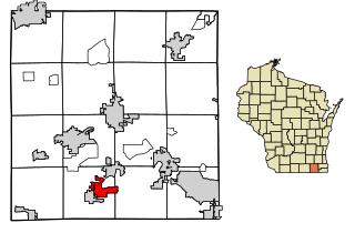
Combined Locks is a village in Outagamie County, Wisconsin, United States. The population was 3,328 at the 2010 census.

<span class="mw-page-title-main">Union Grove, Wisconsin</span> Village in Wisconsin, United States

Union Grove is a village in Racine County, Wisconsin, United States. The population was 4,806 at the 2020 census.

<span class="mw-page-title-main">Bowler, Wisconsin</span> Village in Wisconsin, United States

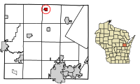
Bowler is a village in Shawano County, Wisconsin, United States. The population was 302 at the 2010 census.

<span class="mw-page-title-main">Fontana-on-Geneva Lake, Wisconsin</span> Village in Wisconsin, United States

Fontana-on-Geneva Lake is a village located on Geneva Lake in Walworth County, Wisconsin, United States. The population was 3,120 at the 2020 census.

<span class="mw-page-title-main">Lac La Belle, Wisconsin</span> Village in Wisconsin, United States

Lac La Belle is a village located mostly in Waukesha County in the U.S. state of Wisconsin. The population was 281 at the 2020 census. The village is located mostly within the town of Oconomowoc in Waukesha County. On March 28, 2002, the village annexed a portion of land in the town of Ixonia in Jefferson County.

<span class="mw-page-title-main">Embarrass, Wisconsin</span> Village in Wisconsin, United States

Embarrass is a village in Waupaca County, Wisconsin, United States. The population was 404 at the 2010 census.

<span class="mw-page-title-main">Pulaski, Wisconsin</span> Village in Wisconsin, United States

Pulaski is a village in Brown, Oconto, and Shawano counties in the U.S. state of Wisconsin. The population was 3,539 at the 2010 census. Of this, 3,321 were in Brown County, 218 in Shawano County, and none in Oconto County.

<span class="mw-page-title-main">Birnamwood, Wisconsin</span> Village in Wisconsin, United States

Birnamwood is a village in Marathon and Shawano counties in the U.S. state of Wisconsin. It is part of the Wausau, Wisconsin Metropolitan Statistical Area. The population was 818 at the 2010 census. Of this, 802 were in Shawano County, and 16 were in Marathon County. The village is located mostly within the town of Birnamwood in Shawano County; only a small portion extends into the town of Norrie in adjacent Marathon County.

<span class="mw-page-title-main">Clyman, Wisconsin</span> Village in Wisconsin, United States

Clyman is a village in Dodge County, Wisconsin, United States. The population was 422 at the 2010 census. The village is located within the Town of Clyman.

<span class="mw-page-title-main">Lowell, Wisconsin</span> Village in Wisconsin, United States

Lowell is a village in Dodge County, Wisconsin, United States, along the Beaver Dam River. The population was 340 at the 2010 census. The village is located within the Town of Lowell.

<span class="mw-page-title-main">Oconto Falls, Wisconsin</span> City in Wisconsin, United States

Oconto Falls is a city in Oconto County, Wisconsin, United States. The population was 2,957 at the 2020 census. It is part of the Green Bay Metropolitan Statistical Area.

<span class="mw-page-title-main">Darien, Wisconsin</span> Village in Wisconsin, United States

Darien is a village in Walworth County, Wisconsin, United States. The population was 1,573 at the 2020 census. The village is located within the Town of Darien.

<span class="mw-page-title-main">East Troy, Wisconsin</span> Village in Wisconsin, United States

East Troy is a Village in Walworth County, Wisconsin, United States. The population was 5,673 at the 2020 census. The Village is located southwest of the Town of East Troy. A small portion extends into the adjacent Town of Troy.

References

  1. Village of Nichols Homepage
  2. "2019 U.S. Gazetteer Files". United States Census Bureau. Retrieved August 7, 2020.
  3. 1 2 "US Board on Geographic Names". United States Geological Survey. October 25, 2007. Retrieved January 31, 2008.
  4. 1 2 "U.S. Census website". United States Census Bureau . Retrieved November 18, 2012.
  5. 1 2 "Population and Housing Unit Estimates". United States Census Bureau. May 24, 2020. Retrieved May 27, 2020.
  6. "U.S. Census website". United States Census Bureau . Retrieved January 31, 2008.
  7. "US Gazetteer files: 2010, 2000, and 1990". United States Census Bureau. February 12, 2011. Retrieved April 23, 2011.
  8. "US Gazetteer files 2010". United States Census Bureau. Archived from the original on January 25, 2012. Retrieved November 18, 2012.
  9. "Census of Population and Housing". Census.gov. Retrieved June 4, 2015.