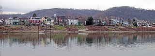
West Overton is located approximately 40 miles (64 km) southeast of Pittsburgh, in East Huntingdon Township, Westmoreland County, Pennsylvania, United States. It is on PA 819 between the towns of Mount Pleasant and Scottdale. Its latitude is 40.117N and its longitude is -79.564W.

The Ybor City Historic District is a U.S. National Historic Landmark District located in Ybor City, Tampa, Florida. The district is bounded by 6th Avenue, 13th Street, 10th Avenue and 22nd Street, East Broadway between 13th and 22nd Streets. Ybor City contains a total of 956 historic buildings, including an unparalleled collection of architecture with Spanish-Cuban influence, as well as historic cigar factory buildings and associated infrastructure. The area was developed by businessman Vicente Martinez Ybor beginning in 1886, and was for a time the world's leading supplier of cigars.

The Montgomery–Grand–Liberty Streets historic district was the first of two to be designated in the city of Newburgh, New York, United States. It runs along the three named north-south streets in the northeast quadrant of the city and includes 250 buildings in its 1,010 acres (4.1 km2). The later East End Historic District is nearby.
Overhills is an unincorporated community located in the Johnsonville Township of Harnett County, North Carolina, United States, near the Cumberland County town of Spring Lake. It is a part of the Dunn Micropolitan Area, which is also a part of the greater Raleigh–Durham–Cary Combined Statistical Area (CSA) as defined by the United States Census Bureau.

Borough House Plantation, also known as Borough House, Hillcrest Plantation and Anderson Place, is an historic plantation on South Carolina Highway 261, 0.8 miles (1.3 km) north of its intersection with U.S. Route 76/US Route 378 in Stateburg, in the High Hills of Santee near Sumter, South Carolina. A National Historic Landmark, the plantation is noted as the largest assemblage of high-style pisé structures in the United States. The main house and six buildings on the plantation were built using this technique, beginning in 1821. The plantation is also notable as the home of Confederate Army General Richard H. Anderson.

San Juan Bautista State Historic Park is a California state park encompassing the historic center of San Juan Bautista, California, United States. It preserves a significant concentration of buildings dating to California's period of Spanish and Mexican control. It includes the Mission San Juan Bautista, the Jose Castro House, and several other buildings facing the historic plaza. It became a state park in 1933 and was declared a National Historic Landmark in 1970. It is also a site on the Juan Bautista de Anza National Historic Trail.

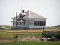
The Red Rocks State Historic Site is a Kansas historic site at 927 Exchange Street in Emporia, Kansas. It preserves the William Allen White House, also known as Red Rocks, which was the home of Progressive journalist William Allen White from 1899 until his death in 1944. The house was declared a National Historic Landmark in 1976. The property, designated a state historic site in 2001, is operated by the Kansas Historical Society.

The Philadelphia Lazaretto was the first quarantine hospital in the United States, built in 1799, in Tinicum Township, Delaware County, Pennsylvania. The site was originally inhabited by the Lenni Lenape, and then the first Swedish settlers. Nearby Province Island was the site of the confinement of the Christian Moravian Indians who were brought there under protective custody from Lancaster, Pennsylvania, in 1763 when their lives were threatened by the Paxton Boys. The facility predates similar national landmarks such as Ellis Island Immigrant Hospital and Angel Island and is considered both the oldest surviving quarantine hospital and the last surviving example of its type in the U.S.

Chestertown Historic District is a historic district in Chestertown, Maryland. It was listed on the National Register of Historic Places and designated a National Historic Landmark in 1970, and its area was increased in 1984. The town on the Chester River, became the chief port for tobacco and wheat on the Eastern Shore of Maryland between 1750 and 1790. The port declined thereafter, as Baltimore became the major port for such activity. In consequence, Chestertown acquired a collection of more than fifty Georgian style town houses. The 18th-century residential area survived without harm a 1910 fire that destroyed the central business district of Chestertown.

Old Homer Village Historic District is a national historic district located at Homer in Cortland County, New York. The district includes the historic core of the village of Homer centered on the village green. It includes a mix of residential, commercial, civic, and religious structures. Residences are primarily 2-story frame structures and commercial structures are 2- and 3-story structures constructed of brick. Included within the district is the Homer Town Hall (1908), the 3+1⁄2-story Jebediah Barber building (1863), 3-story Brockway Block (1887–1888), and residences dating to the 1810s. Also located within the district boundaries is the U.S. Post Office.

Hillsborough Historic District is a national historic district located at Hillsborough, Orange County, North Carolina. The district encompasses 529 contributing buildings, 9 contributing sites, 13 contributing structures, and 2 contributing objects in the central business district and surrounding residential sections of Hillsborough. The district includes buildings dating to the late-18th and early-20th century and includes notable examples of Federal, Greek Revival, and Italianate style architecture. Located in the district are the separately listed Burwell School, Eagle Lodge, Hazel-Nash House, Heartsease, Montrose, Nash Law Office, Nash-Hooper House, Old Orange County Courthouse, Poplar Hill, Ruffin-Roulhac House, Sans Souci, and St. Matthew's Episcopal Church and Churchyard. Other notable buildings include Seven Hearths, the Presbyterian Church (1815-1816), Methodist Church (1859-1860), First Baptist Church (1862-1870), Twin Chimneys, and the Berry Brick House.

Malden Historic District is a national historic district located within the town of Malden, located in Kanawha County, West Virginia.
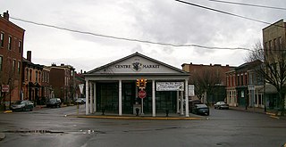
Centre Market Square Historic District is a historic district in Wheeling, West Virginia, listed on the National Register of Historic Places.

North Wheeling Historic District is a national historic district located at Wheeling, Ohio County, West Virginia. The district encompasses 134 contributing buildings and one contributing object in a 2 1/2-block section of northern Wheeling, known as "Old Town". Most of the district consists of mid- to late-19th-century residential buildings. A number of popular architectural styles are represented, including Greek Revival, Italianate, and Late Victorian. Notable buildings include the Vigilant Engine House, William Goering House (1885), Alfred Paull House (1880s), Williams Duplex Tenement (1880–1884), George W. Eckhart House (1891–1892), Christian Hess House (1876), Edward Hazlett House (1893), Henry K. List House (1858). The object is the Pollack Memorial Monument (1916).

Wheeling Historic District, also known as the Wheeling Central Business District, is a national historic district located at Wheeling, Ohio County, West Virginia. The district includes 205 contributing buildings in the central business district of Wheeling. It includes the site of the original location of Fort Henry. The buildings are representative of a number of popular architectural styles from the early-19th century through the present including Greek Revival and Late Victorian. The District was listed on the National Register of Historic Places in 1979.
Wheeling Island Historic District is a national historic district located on Wheeling Island in Wheeling, Ohio County, West Virginia. The district includes 1,110 contributing buildings, 5 contributing sites, 2 contributing structures, and 3 contributing objects. It is a largely residential district consisting of two-story, frame detached dwellings built in the mid- to late-19th and early-20th century, including the Irwin-Brues House (1853) and a number of houses on Zane Street. The houses are representative of a number of popular architectural styles including Bungalow, Italianate, Queen Anne, and Colonial Revival. Notable non-residential contributing properties include the Exposition Building (1924), Thompson United Methodist Church (1913-1915), Madison School (1916), firehouse (1930-1931), the Bridgeport Bridge (1893), the Aetnaville Bridge (1891), "The Marina," Wheeling Island Baseball Park, and "Belle Island Park." It includes the separately listed Wheeling Suspension Bridge, Harry C. and Jessie F. Franzheim House, and John McLure House.

John Turn Farm is a historic farm complex located in the Delaware Water Gap National Recreation Area at Middle Smithfield Township, Monroe County, Pennsylvania, USA. The complex includes the lime kiln, smoke house and weave house. The property also includes the site of the demolished main farmhouse, a smaller house, a barn and garage.
The Western Branch of the National Home for Disabled Soldiers was established in 1885 in Leavenworth, Kansas to house aging veterans of the American Civil War. The 214-acre (87 ha) campus is near Fort Leavenworth, and is directly adjacent to Leavenworth National Cemetery, south of Leavenworth town. The home features about 82 contributing building resources, constructed between the 1880s and the 1940s. It is now part of the Department of Veterans Affairs Eisenhower Medical Center.

The Oldwick Historic District is a 170-acre (69 ha) national historic district located along County Route 517, Church, King, James, Joliet and William streets in the Oldwick section of Tewksbury Township in Hunterdon County, New Jersey. The district was added to the National Register of Historic Places on November 14, 1988, for its significance in architecture, commerce, and industry. It includes 127 contributing buildings, 12 contributing structures, and one contributing site. The Kline Farmhouse, listed individually in 1984, also contributes to the district. Many of the buildings were documented by the Historic American Buildings Survey.

The Old Mine Road Historic District is a 687-acre (278 ha) historic district located along Old Mine Road in Sussex County and Warren County, New Jersey. It is part of the Delaware Water Gap National Recreation Area. The district was added to the National Register of Historic Places on December 3, 1980, for its significance in agriculture, archaeology, architecture, commerce, exploration/settlement, and transportation. It includes 24 contributing buildings and five contributing sites.