Cedar Bluff State Park is a public recreation area located 21 miles (34 km) southeast of WaKeeney and 23 miles (37 km) southwest of Ellis in Trego County, Kansas, United States.

Cheney State Park is a state park of Kansas in the United States. Completed in 1964, the park is located in Kingman and Reno counties in Kansas, 5 miles north of Cheney and 20 miles west of Wichita.
Clinton State Park is a public recreation area located on the north shore of Clinton Lake at the western edge of Lawrence, Kansas, United States.

Crawford State Park is a state park in Crawford County, Kansas, United States, located 9 miles (14 km) north of Girard.

Cross Timbers State Park is a state park in Woodson County, Kansas, United States. It is located immediately south of Toronto.
Elk City State Park is a state park in Montgomery County, Kansas, United States, located west of Independence.

Perry Lake is a US Army Corps of Engineers operated reservoir in northeast Kansas. Its primary purposes are flood control, water reserve for nearby areas and regional recreation. The lake is approximately 11,150 acres (45 km²) in size, with over 160 miles of shoreline. Perry Lake's full multi-purpose pool elevation is 891.5 feet above sea level. Perry Lake is located about 40 miles west of Kansas City, just northwest of Lawrence, Kansas. Its close proximity to Kansas City, Lawrence, and the state capitol, Topeka, make it a very popular destination, with the nickname "Paradise on the Plains".

El Dorado Lake is a reservoir on the Walnut River 0.5 miles (0.80 km) northeast of El Dorado in the Flint Hills region of Kansas. Built and managed by the U.S. Army Corps of Engineers, it is used for flood control, recreation, and water supply. El Dorado State Park is located on its shore.

McGee Creek State Park is a state park in southern Oklahoma. The park is on the south side of McGee Creek Reservoir. Created in 1985 the reservoir provides flood control. The park is approximately 2,600 acres (1,100 ha) and the reservoir is approximately 3,800 acres (1,500 ha). Its main staple is recreational and sport fishing. The main fish fished for in this park include Crappie, Sunfish, Largemouth bass, and Channel catfish. The McGee Creek Wildlife Management area is located between the two arms of the reservoir.

John Redmond Reservoir is a reservoir on the Neosho River in eastern Kansas. Built and managed by the U.S. Army Corps of Engineers, it is used for flood control, recreation, water supply, and wildlife management. It borders the Flint Hills National Wildlife Refuge to the northwest.

Keith Sebelius Lake, formerly known as Norton Reservoir, is a man-made reservoir on Prairie Dog Creek in northwest Kansas. Built and managed by the U.S. Bureau of Reclamation, it is used for flood control, irrigation, recreation, and local water supply. Prairie Dog State Park is located on its shore.
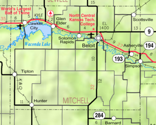
Waconda Lake, also known as Glen Elder Reservoir, is a reservoir in Mitchell County and Osborne County, Kansas, United States. Built and managed by the U.S. Bureau of Reclamation for flood control and irrigation, it is also used for recreation. Glen Elder State Park is located on its north shore.

Lovewell Reservoir is a reservoir in Jewell County, Kansas, United States. Built and managed by the U.S. Bureau of Reclamation, it is used for flood control, irrigation, and recreation. Lovewell State Park is located on its north shore.

Cedar Bluff Reservoir is a reservoir in Trego County, Kansas, United States. Built and managed by the U.S. Bureau of Reclamation for irrigation and area water supply, it is also used for flood control and recreation. Cedar Bluff State Park is located on its shore.

Webster Reservoir is a reservoir in Rooks County, Kansas, United States. Built and managed by the U.S. Bureau of Reclamation, it is used for flood control, irrigation, and recreation. Webster State Park is located on its shore.

Kanopolis Lake is a reservoir in Ellsworth County in the Smoky Hills of central Kansas, about 31 miles southwest of Salina and a few miles southeast of the town of Kanopolis. The lake is formed by Kanopolis Dam. Completed in 1948 as a flood control and water conservation project of the United States Army Corps of Engineers, the dam impounds the Smoky Hill River.

Cheney Reservoir is a reservoir on the North Fork Ninnescah River in Reno, Kingman, and Sedgwick counties of Kansas in the United States. Built and managed by the U.S. Bureau of Reclamation for local water supply, it is also used for flood control and recreation. Cheney State Park is located on its shore.

Council Grove Lake is a reservoir on the Neosho River in east-central Kansas. Built and managed by the U.S. Army Corps of Engineers, it is used for flood control, recreation, and water supply.

Cooney State Park is a public recreation area bordering Cooney Reservoir, fourteen miles (23 km) south of Columbus in Carbon County, Montana. The state park occupies 309 acres (125 ha) on three sides of the reservoir, a 1,078-acre (436 ha) impoundment of Red Lodge Creek completed in 1937. The park offers boating, fishing, swimming, picnicking, and camping.