Nobscot Hill

Last updated
Nobscot Hill
View of Nobscot Hill in Framingham from Wayland MA.jpg
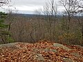
View of Nobscot Hill from Wayland
Highest point
Elevation 600 ft (180 m)
Coordinates 42°20′45″N71°26′57″W / 42.34583°N 71.44917°W / 42.34583; -71.44917
Geography
Location Middlesex County, Massachusetts
Topo map USGS Framingham

Nobscot Hill is a USGS name [1] for a high point in Middlesex County, Massachusetts with many public hiking trails, and the hill is located in Framingham and Sudbury. At the summit are various radio towers and a fire tower. Below the summit of Nobscot Hill is the Nobscot Scout Reservation (452 acres) which includes Tippling Rock, a popular viewing location. Surrounding the hill are other large parks and parcels of conservation land, including the Nobscot Conservation Land (118 acres), Callahan State Park (958 acres), the Sudbury Weisblatt Conservation Land, and Wittenborg Woods (83 acres), [2] which are connected by various hiking trails, including the Bay Circuit Trail.

Contents

Geography

The summit of Nobscot Hill commands a 360-degree view including Boston, MetroWest, the Blue Hills, Lower Kearsarge, Mount Monadnock, Mount Wachusett, Mount Agamenticus, and all of the unremarkable bumps to the SouthWest. Currently, the foliage obscures much of the view from the summit, unless one climbs the fire tower when it is open, but other nearby viewing points, including nearby Jethro's Table and Tippling Rock, offer an unobstructed views to Boston. Other smaller hills surround Nobscot, including Doeskin Hill to the west, which was named in the seventeenth century after someone who lost a deerskin glove on the hill, [3] :25 and Tantamous Hill to the east, which was named after the medicine man who lived on Nobscot.

History

By 1657 the area appeared in the records by the Nipmuc name "Penobscot" (meaning “Place of the Falling Rock”) and was later shortened to "Nobscot." [4] Nobscot was considered a spiritual place for the Nipmuc people who resided in the area, and there was also a large stone cairn at the summit which possibly served as a lookout area for the Indians. A Nipmuc medicine man named Tantamous, also known as Old Jethro, and his son, Peter Jethro and twelve others, lived on Nobscot Hill prior to King Philip’s War when they were removed in 1675 to Deer Island. [5] The Jethros had fruit orchards and cornfields on the sides of the hill, and many large Indian grinding stones are still viewable. Jethro's Field at Nobscot was referred to in the records by 1649, [6] and references were also made to Peter's Field and Concubine's field in various deeds. [3] :29 Tippling Rock may have been used to communicate between local Indian villages (the rock was blasted in half in the early 20th century possibly by a local farmer). [7] Jethro also had a granary and cairn (lookout) which was rebuilt in 1927 and was 8 feet in diameter and 5.5 feet tall with a flat smooth stone on top. [8]

In the 1700s Revolutionary War General, John Nixon lived and farmed on the north side of Nobscot Hill and the cellar hole of his house is viewable. [9] During a 1792 outbreak of small pox a pest house was constructed at the base of Nobscot for quarantining the sick and a small burial ground was built for victims who succumbed, and this cemetery and the cellar hole of the pest house may be visited today.

The area around Nobscot was used for farming for many years. Henry David Thoreau visited Nobscot in the 1850s and wrote about viewing the hill and about a waterfall near the hill. [10] [11] In the 1920s and 1930s Henry Ford purchased hundreds of acres of land around Nobscot Hill and the Wayside Inn to recreate an authentic early American village, similar to what he eventually built at Greenfield Village in Michigan. [4] Ford constructed a large dam at the base of the hill in the 1930s to create a reservoir to support firefighting near his proposed village, but the dam failed to hold water and is now known as "Ford's Folly," and can be visited by the hiking trails around Nobscot. [4] In 1928 the Boy Scouts purchased a large reservation on Nobscot Hill which is still owned by the organization, but the area is open to the general public as invited guests. [12] In 2008, a 303-acre (1.23 km2) portion of the Nobscot Scout Reservation in Sudbury was permanently conserved by Sudbury Valley Trustees, the Town of Sudbury, and the Mayflower Council, Boy Scouts of America.

Related Research Articles

<span class="mw-page-title-main">Scouting in Massachusetts</span>

Scouting in Massachusetts includes both Girl Scout and Boy Scouts of America (BSA) organizations. Both were founded in the 1910s in Massachusetts. With a vigorous history, both organizations actively serve thousands of youth in programs that suit the environment in which they live.

<span class="mw-page-title-main">Sudbury, Massachusetts</span> Town in Massachusetts, United States

Sudbury is a town in Middlesex County, Massachusetts, United States. At the 2020 census, it had a population of 18,934. The town, located in Greater Boston's MetroWest region, has a rich colonial history.

<span class="mw-page-title-main">Framingham, Massachusetts</span> City in Massachusetts, US

Framingham is a city in the Commonwealth of Massachusetts in the United States. Incorporated in 1700, it is located in Middlesex County and the MetroWest subregion of the Greater Boston metropolitan area. The city proper covers 25 square miles (65 km2) with a population of 72,362 in 2020, making it the 14th most populous municipality in Massachusetts. Residents voted in favor of adopting a charter to transition from a representative town meeting system to a mayor–council government in April 2017, and the municipality transitioned to city status on January 1, 2018. Before it transitioned, it had been the largest town by population in Massachusetts.

<span class="mw-page-title-main">Mount Greylock</span> United States historic place

Mount Greylock is a 3,489-foot (1,063-meter) mountain located in the northwest corner of Massachusetts and is the highest point in the state. Its summit is in the western part of the town of Adams in Berkshire County. Geologically, Mount Greylock is part of the Taconic Mountains, which are not associated with the abutting Berkshire Mountains to the east. The mountain is known for its expansive views encompassing five states and the only taiga-boreal forest in the state. A seasonal automobile road provides access to the summit. In 1932, the Commonwealth built the Massachusetts Veterans War Memorial Tower atop the summit. A network of hiking trails traverses the mountain, including the Appalachian Trail. Mount Greylock State Reservation was created in 1898 as Massachusetts' first public land for the purpose of forest preservation.

<span class="mw-page-title-main">Walden Pond</span> Pond in Concord, Massachusetts

Walden Pond is a famous pond in Concord, Massachusetts, in the United States. A good example of a kettle hole, it was formed by retreating glaciers 10,000–12,000 years ago. The pond is protected as part of Walden Pond State Reservation, a 335-acre (136 ha) state park and recreation site managed by the Massachusetts Department of Conservation and Recreation. The reservation was designated a National Historic Landmark in 1962 for its association with the writer Henry David Thoreau (1817–1862), whose two years living in a cabin on its shore provided the foundation for his famous 1854 work, Walden; or, Life in the Woods. The National Historic Preservation Act of 1966 ensured federal support for the preservation of the pond.

Mount Wachusett is a mountain in Massachusetts. It straddles towns of Princeton and Westminster, in Worcester County. It is the highest point in Massachusetts east of the Connecticut River. The mountain is named after a Native American term meaning "near the mountain" or "mountain place". The mountain is a popular hiking and skiing destination. An automobile road, open spring to fall, ascends to the summit. Views from the top of Mount Wachusett include Mount Monadnock to the north, Mount Greylock to the west, southern Vermont to the northwest, and Boston to the east. The mountain is traversed by the 92 mi (148 km) Midstate Trail. It is also home to the Wachusett Mountain State Reservation.

<span class="mw-page-title-main">Mount Blue (Maine)</span>

Mount Blue is a mountain in Maine, USA. It is a hiking destination with outstanding views from the observation deck of a tower at the summit. Its name is shared with Mount Blue State Park in Weld and Mount Blue High School in Farmington.

<span class="mw-page-title-main">Mount Grace</span>

Mount Grace, 1,617 feet (493 m), is a prominent monadnock located in north central Massachusetts in the town of Warwick, approximately two miles south of the New Hampshire border. The mountain is rugged and largely wooded, but a firetower on the summit provides expansive views of the surrounding rural countryside. Little Mount Grace, 1,226 feet (374 m), is the southern summit of the mountain. Mount Grace supports a predominantly northern hardwood forest as well as stands of red spruce near its summit.

<span class="mw-page-title-main">Mayflower Council</span>

The Mayflower Council of the Boy Scouts of America serves the MetroWest and southeastern regions of Massachusetts.

Tyringham Cobble is a 206-acre (83 ha) open space reservation located in Tyringham, Massachusetts on 411 m (1,348 ft) Cobble Hill in The Berkshires. It is managed by The Trustees of Reservations, a non-profit conservation organization, and is notable for its scenic views over the rural landscape of Tyringham Valley from rocky ledges and open fields. The reservation consists of the hill and surrounding agricultural and pasture land. In 2008, part of the 2,175 mile (3,500 km) Appalachian Trail was routed over the summit ledges.

<span class="mw-page-title-main">Massaemett Mountain</span> Mountain in Massachusetts, United States of America

Massaemett Mountain is a mountain in Shelburne, Franklin County, Massachusetts, USA. It is named for a chief of the Pocumtuck tribe, a confederacy of Native Americans who inhabited the region. Part of the Berkshire Mountains, Massaemett lies just east of the village of Shelburne Falls, 7 miles (11 km) west of the county seat of Greenfield, Massachusetts, and 87 miles (140 km) west of Boston. The summit features a historic stone fire tower constructed in 1909. The top cab is not open to the public, however the stairway is kept open and offers views from multiple windows facing the four directions of the compass. From the tower, views include the Berkshires and Taconic Mountains to the west, the Green Mountains of Vermont to the north, Mount Wachusett to the east, and the Holyoke Range to the south.

<span class="mw-page-title-main">Berlin Mountain</span> Mountain on border between Massachusetts and New York, United States

Berlin Mountain is a 2,818-foot-tall (859 m) prominent peak in the Taconic Mountains of western New England and is located adjacent to Massachusetts's border with New York State. It is the highest point in Rensselaer County. The summit and west side of the mountain are located in New York; the east side lies within Williamstown, Massachusetts. The mountain is a bald, notable for its grassy summit and expansive views of the Hudson River Valley to the west. The 37-mile (60 km) Taconic Crest Trail traverses the mountain. Several other hiking trails approach the summit from the east. Much of the upper slopes and summit are within protected conservation land. Historically the lower slopes of the mountain were farmed heavily throughout the 19th Century. In addition to agriculture, there are several remnants of charcoal kilns located on the mountain that produced fuel for iron smelting.

<span class="mw-page-title-main">Bay Circuit Trail</span> Long-distance hiking trail in the United States

The Bay Circuit Trail and Greenway or Bay Circuit is a Massachusetts rail trail and greenway connecting the outlying suburbs of Boston from Plum Island in Newburyport to Kingston Bay in Duxbury, a distance of 200 miles (320 km).

<span class="mw-page-title-main">Moose Hill Farm</span>

Moose Hill Farm is a 347-acre (140 ha) open space preserve and historic farm complex located in Sharon, Massachusetts near the 450 feet (140 m) summit of Moose Hill. The property, acquired in 2005 by the land conservation non-profit organization The Trustees of Reservations, includes farmland, woodlots, 21 farm buildings, hiking trails, stands of mature American Chestnuts, and scenic vistas of the Boston skyline. Moose Hill Farm is part of a larger area of protected open space including state land and the Massachusetts Audubon Society's Moose Hill Wildlife Sanctuary.

<span class="mw-page-title-main">Fairhaven Bay</span> Bay in Massachusetts, United States of America

Fairhaven Bay is a lake located within the Sudbury river in Concord, Massachusetts, United States (US). It was frequented by Henry David Thoreau who, together with Edward Hoar, accidentally set fire to the woods near the bay in April 1844, as later described in Thoreau's journal.

<span class="mw-page-title-main">Beebe Hill State Forest</span> State forest in New York, United States

Beebe Hill State Forest is a state forest in the town of Austerlitz, Columbia County, New York, United States. Compromising 1,383 acres (560 ha) in the Taconic Mountains, it adjoins Harvey Mountain State Forest to the southeast. With around 30 mi (48 km) of multiple-use trails, the area is managed for environmental protection, recreation, and timber harvesting. The 6.5-acre (2.6 ha) Barrett Pond is located within the state forest on the west side of Columbia County Route 5, and was home to numerous fish species when last sampled in 1983.

<span class="mw-page-title-main">Tantamous</span> Nipmuc leader

Tantamous was a well-known Native American Nipmuc leader in seventeenth century Massachusetts. Tantamous was a powwow who lived near the Assabet River, later in Nobscot. Tantamous "...may have gotten his English name for his good advice."

Peter Jethro was an early Native American (Nipmuc) scribe, translator, minister, land proprietor, and Praying Indian affiliated for a period with John Eliot in the praying town of Natick, Massachusetts.

<span class="mw-page-title-main">Summer Hill (Maynard, Massachusetts)</span>

Summer Hill is a 351-foot (107 m) hill overlooking the Assabet River in Maynard, Massachusetts "with a gradual slope to the north and west". Today the hill is largely conservation land with 24 acres of public hiking trails, and the summit of hill also contains a radio tower and the town's steel and concrete water tanks. It is the highest point in Maynard.

<span class="mw-page-title-main">Mount Misery (Lincoln, Massachusetts)</span> Hill in Lincoln, Massachusetts, US

Mount Misery is a 284-foot hill and public conservation land in Lincoln, Massachusetts, on Route 117 and on the Bay Circuit Trail near the Sudbury River. Containing 227 acres (92 ha), Mount Misery is the largest piece of conservation land in the town and contains seven miles of public hiking trails through hills, wetlands and agricultural fields.

References

  1. "GNIS Detail - Nobscot Hill". geonames.usgs.gov.
  2. "Wittenborg Woods | City of Framingham, MA Official Website".
  3. 1 2 Temple, Josiah Howard, History of Framingham, Massachusetts: Early Known as Danforth's ... (1887) Framingham, Mass.
  4. 1 2 3 "Nobscot Conservation Land » Sudbury".
  5. "Preserving Nobscot's history - Sudbury, MA - the Sudbury Town Crier". Archived from the original on 9 February 2013.
  6. Sud. Rcs: Order of 1640: "Jethro's Field"
  7. "Tippling Rock Hiking".
  8. "Rebuild Indian Cairn on Nobscot Mountain," The Boston Globe, Sept. 12, 1927, p. 11
  9. Hudson, Alfred Sereno. (1889). The History of Sudbury, Massachusetts. Town of Sudbury. 661pp.Download PDF
  10. "Thoreau--Natural History of Massachusetts".
  11. "The Project Gutenberg eBook of the Writings of Henry David Thoreau, Journal II, 1850-September 15, 1851, by Henry David Thoreau".
  12. Allan Jung, "Scouting around MetroWest’s Nobscot Reservation," MetroWest Daily News, Oct 23, 2008