North Norwich, New York

Last updated

North Norwich, New York
Chenango County NY North Norwich town highlighted.svg
USA New York location map.svg
Red pog.svg
North Norwich
Location within the state of New York
Coordinates: 42°36′33″N75°30′29″W / 42.60917°N 75.50806°W / 42.60917; -75.50806
Country United States
State New York
County Chenango
Government
  Type Town Council
   Town Supervisor Richard B. Decker (R)
   Town Council
Members' List
Area
[1]
  Total28.24 sq mi (73.15 km2)
  Land28.14 sq mi (72.89 km2)
  Water0.10 sq mi (0.27 km2)
Elevation
1,512 ft (461 m)
Population
 (2010)
  Total1,783
  Estimate 
(2016) [2]
1,733
  Density61.58/sq mi (23.78/km2)
Time zone UTC-5 (Eastern (EST))
  Summer (DST) UTC-4 (EDT)
ZIP code
13814
Area code 607
FIPS code 36-017-53297
GNIS feature ID0979291

North Norwich is a town in Chenango County, New York, United States. The population was 1,783 at the 2010 census. [3] The town is directly north of the City of Norwich in the eastern half of the county.

Contents

History

Historic marker of the Chenango Canal, canal and towpath at North Norwich Chenango Canal 7 North Norwich NY .JPG
Historic marker of the Chenango Canal, canal and towpath at North Norwich

The first settlement began circa 1794. The town of North Norwich was established in 1849 from the northern part of the town of Norwich.

The former Chenango Canal passed through the town.

Geography

According to the United States Census Bureau, the town has a total area of 28.3 square miles (73.2 km2), of which 28.1 square miles (72.9 km2) is land and 0.12 square miles (0.3 km2), or 0.36%, is water. [3]

New York State Route 12 (north-south) is a major highway through the town. New York State Route 320 is a short highway near the southern town line.

The Chenango River, a tributary of the Susquehanna River, flows southward through the town.

Demographics

Historical population
CensusPop.Note
1850 1,172
1860 1,171−0.1%
1870 1,075−8.2%
1880 964−10.3%
1890 858−11.0%
1900 801−6.6%
1910 691−13.7%
1920 619−10.4%
1930 68911.3%
1940 77011.8%
1950 87513.6%
1960 1,09625.3%
1970 1,57944.1%
1980 1,6876.8%
1990 1,99818.4%
2000 1,966−1.6%
2010 1,783−9.3%
2016 (est.)1,733 [2] −2.8%
U.S. Decennial Census [4]

As of the census [5] of 2000, there were 1,966 people, 727 households, and 532 families residing in the town. The population density was 69.7 inhabitants per square mile (26.9/km2). There were 797 housing units at an average density of 28.2 per square mile (10.9/km2). The racial makeup of the town was 98.42% White, 0.51% African American, 0.05% Native American, 0.51% Asian, 0.05% Pacific Islander, 0.05% from other races, and 0.41% from two or more races. Hispanic or Latino of any race were 0.51% of the population.

There were 727 households, out of which 35.5% had children under the age of 18 living with them, 58.6% were married couples living together, 9.2% had a female householder with no husband present, and 26.8% were non-families. 19.5% of all households were made up of individuals, and 8.9% had someone living alone who was 65 years of age or older. The average household size was 2.70 and the average family size was 3.06.

In the town, the population was spread out, with 28.1% under the age of 18, 6.6% from 18 to 24, 29.0% from 25 to 44, 24.9% from 45 to 64, and 11.3% who were 65 years of age or older. The median age was 36 years. For every 100 females, there were 96.2 males. For every 100 females age 18 and over, there were 95.7 males.

The median income for a household in the town was $37,450, and the median income for a family was $42,414. Males had a median income of $30,605 versus $22,109 for females. The per capita income for the town was $17,022. About 12.0% of families and 16.1% of the population were below the poverty line, including 19.5% of those under age 18 and 10.0% of those age 65 or over.

Communities and locations in North Norwich

Related Research Articles

<span class="mw-page-title-main">Chenango, New York</span> Town in New York, United States

Chenango is a town in Broome County, New York, United States. The population was 10,983 at the 2020 census.

<span class="mw-page-title-main">Fenton, New York</span> Town in New York, United States

Fenton is a town in Broome County, New York, United States. The population was 6,441 at the 2020 census. The town was named after Reuben Fenton, a governor of New York.

<span class="mw-page-title-main">Triangle, New York</span> Town in New York, United States

Triangle is a town in Broome County, New York, United States. The population was 2,946 at the 2010 census. The town's primary settlement is the village of Whitney Point.

<span class="mw-page-title-main">Columbus, New York</span> Town in New York, United States

Columbus is a town in Chenango County, New York, United States. The population was 975 at the 2010 census. Columbus is in the northeastern corner of the county and is northeast of Norwich.

<span class="mw-page-title-main">Coventry, New York</span> Town in New York, United States

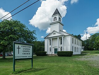
Coventry is a town in Chenango County, New York, United States. The population was 1,655 at the 2010 census. The town is named after Coventry, Connecticut, by settlers from New England. Coventry is in the southern part of Chenango County and is northeast of Binghamton.

<span class="mw-page-title-main">German, New York</span> Town in New York, United States

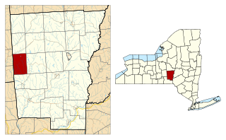
German is a town in Chenango County, New York, United States. The population was 370 at the 2010 census. The town is named after U.S. Senator Obadiah German, the original land owner. The town is at the western border of the county and is west of Norwich.

<span class="mw-page-title-main">Lincklaen, New York</span> Town in New York, United States

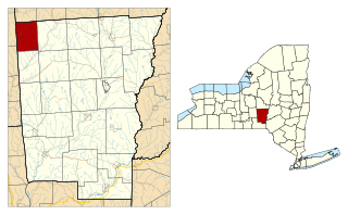
Lincklaen is a town in Chenango County, New York, United States. The population was 396 at the 2010 census. The town was named after Colonel John Lincklaen, an agent of the Holland Land Company and a land owner. The town is in the northwestern corner of the county, northwest of the city Norwich and northeast of Cortland.

<span class="mw-page-title-main">McDonough, New York</span> Town in New York, United States

McDonough is a town in Chenango County, New York, United States. The population was 886 at the 2010 census. The town is named after Thomas Macdonough, a naval officer who served on Lake Champlain and other locations. McDonough is located in the western part of Chenango County, west of Norwich.

<span class="mw-page-title-main">Pharsalia, New York</span> Town in New York, United States

Pharsalia is a town in Chenango County, New York, United States. The population was 593 at the 2010 census. The town was named after Pharsalia, which is a commonly accepted name of the decisive battle in the Great Roman Civil War, where Julius Caesar defeated Pompey in 48 BCE.

<span class="mw-page-title-main">Pitcher, New York</span> Town in New York, United States

Pitcher is a town in Chenango County, New York, United States. The population was 803 at the 2010 census. The town is named after Nathaniel Pitcher, the eighth governor of New York. The town is on the western border of Chenango County, west of the city of Norwich.

<span class="mw-page-title-main">Plymouth, New York</span> Town in New York, United States

Plymouth is a town in Chenango County, New York, United States. The population was 1,804 at the 2010 census. It is an interior town in the northern part of the county. The town is northwest of the city of Norwich. Plymouth was also known as Plymouth Rock.

<span class="mw-page-title-main">Preston, New York</span> Town in New York, United States

Preston is a town in Chenango County, New York, United States. The population was 1,044 at the 2010 census. Preston is an interior town of Chenango County and is west of the city of Norwich.

<span class="mw-page-title-main">Smithville, New York</span> Town in New York, United States

Smithville is a town in Chenango County, New York, United States. The population was 1,330 at the 2010 census. The town is at the western border of Chenango County, west of the city of Norwich.

Brookfield is a town in Madison County, New York, United States. The population was 2,403 at the 2000 census.

<span class="mw-page-title-main">Sangerfield, New York</span> Town in New York, United States

Sangerfield is a town in Oneida County, New York, United States. The population was 2,561 at the 2010 census. The town is named after Jedediah Sanger, an early settler.

<span class="mw-page-title-main">Bainbridge, New York</span> Town in New York, United States

Bainbridge is a town in Chenango County, New York, United States. The population was 3,308 at the 2010 census. The town is at the eastern border of Chenango County, halfway between Binghamton and Oneonta.

<span class="mw-page-title-main">New Berlin, New York</span> Town in New York, United States

New Berlin is a town in Chenango County, central New York, United States. The population was 2,682 at the 2010 census. The town contains the village of New Berlin. The town is at the eastern border of the county and is northeast of Norwich.

<span class="mw-page-title-main">Norwich (town), New York</span> Town in New York, United States

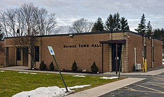
Norwich is a town in Chenango County, New York, United States. The population was 3,998 at the 2010 census.

<span class="mw-page-title-main">Sherburne (village), New York</span> Village in New York, United States

Sherburne is a village in Chenango County, New York, United States. The population was 1,367 at the 2010 census. It is in the town of Sherburne, north of Norwich.

<span class="mw-page-title-main">Smyrna, New York</span> Town in New York, United States

Smyrna is a town in Chenango County, New York, United States. The population was 1,280 at the 2010 census. Smyrna is named after a coastal city in ancient Greece, nowadays modern Izmir in Turkey.

References

  1. "2016 U.S. Gazetteer Files". United States Census Bureau. Retrieved July 4, 2017.
  2. 1 2 "Population and Housing Unit Estimates" . Retrieved June 9, 2017.
  3. 1 2 "Geographic Identifiers: 2010 Demographic Profile Data (G001): North Norwich town, Chenango County, New York". U.S. Census Bureau, American Factfinder. Archived from the original on February 12, 2020. Retrieved November 20, 2014.
  4. "Census of Population and Housing". Census.gov. Retrieved June 4, 2015.
  5. "U.S. Census website". United States Census Bureau . Retrieved January 31, 2008.

42°37′01″N75°31′37″W / 42.61694°N 75.52694°W / 42.61694; -75.52694