Oxford (village), New York

Last updated

Oxford, New York
First National Bank of Oxford building Dec 09.jpg
First National Bank of Oxford building in 2009
USA New York location map.svg
Red pog.svg
Oxford
Location within the state of New York
Coordinates: 42°26′32″N75°35′52″W / 42.44222°N 75.59778°W / 42.44222; -75.59778
Country United States
State New York
County Chenango
Town Oxford
Area
[1]
  Total1.77 sq mi (4.59 km2)
  Land1.77 sq mi (4.59 km2)
  Water0.00 sq mi (0.00 km2)
Elevation
971 ft (296 m)
Population
 (2020)
  Total1,330
  Density750.56/sq mi (289.88/km2)
Time zone UTC-5 (Eastern (EST))
  Summer (DST) UTC-4 (EDT)
ZIP code
13830
Area code 607
FIPS code 36-55948
GNIS feature ID0959713
Website villageofoxfordny.com

Oxford is a village in Chenango County, New York, United States. The population was 1,450 at the 2010 census. [2] The village is named after Oxford, Massachusetts, the hometown of the landowner.

Contents

It is located in the south-central portion of Chenango County, known as the "southern tier," which is 8 miles southwest of the county seat, the City of Norwich. It is situated between the major metropolises of Binghamton to the south and Syracuse to the north and Oneonta to the east and Cortland to the west. [3]

History

The village was founded by its first settlers in 1791, including the landowner Benjamin Hovey (1758–1811) who was later a business partner of Aaron Burr and his cousin Theodore Burr.

The former Chenango Canal passed through the village, connecting the community to Utica and Binghamton.

In 1985, many of its historic buildings were included in the Oxford Village Historic District on the National Register of Historic Places. [4]

Geography

The village of Oxford is located in the northern part of the town of Oxford at 42°26′32″N75°35′52″W / 42.44222°N 75.59778°W / 42.44222; -75.59778 (42.442354, -75.597822), [5] in south-central Chenango County. The Chenango River, a south-flowing tributary of the Susquehanna River, divides the village.

According to the United States Census Bureau, the village has a total area of 1.8 square miles (4.6 km2) all land. [2]

New York State Route 12 (Canal Street) intersects New York State Route 220 (State Street to the west and Main Street to the east) in the village. NY-12 leads northeast 8 miles (13 km) to Norwich, the county seat, and southwest 13 miles (21 km) to Greene.

Demographics

Historical population
CensusPop.Note
1860 1,205
1870 1,2786.1%
1880 1,209−5.4%
1890 1,47722.2%
1900 1,93130.7%
1910 1,654−14.3%
1920 1,590−3.9%
1930 1,6010.7%
1940 1,7137.0%
1950 1,8115.7%
1960 1,8713.3%
1970 1,9443.9%
1980 1,765−9.2%
1990 1,738−1.5%
2000 1,584−8.9%
2010 1,450−8.5%
2020 1,330−8.3%
U.S. Decennial Census [6]

In 2021, Oxford, NY had a population of 1.39k people with a median age of 37 and a median household income of $43,864. Between 2020 and 2021 the population of Oxford, NY declined from 1,422 to 1,392, a −2.11% decrease and its median household income grew from $39,886 to $43,864, a 9.97% increase.

The 5 largest ethnic groups in Oxford, NY are White (Non-Hispanic) (95.6%), Two+ (Hispanic) (2.73%), Black or African American (Non-Hispanic) (0.718%), American Indian & Alaska Native (Hispanic) (0.575%), and Two+ (Non-Hispanic) (0.359%).

None of the households in Oxford, NY reported speaking a non-English language at home as their primary shared language. This does not consider the potential multi-lingual nature of households, but only the primary self-reported language spoken by all members of the household.

100% of the residents in Oxford, NY are U.S. citizens.

In 2021, the median property value in Oxford, NY was $92,500, and the homeownership rate was 65.8%.

Most people in Oxford, NY drove alone to work, and the average commute time was 19.7 minutes. The average car ownership in Oxford, NY was 2 cars per household. [7]

Related Research Articles

<span class="mw-page-title-main">Chenango County, New York</span> County in New York, United States

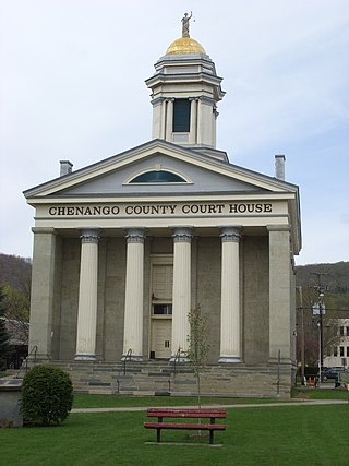
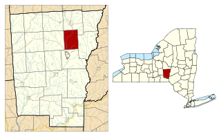
Chenango County is a county located in the south-central section U.S. state of New York. As of the 2020 census, the population was 47,220. Its county seat is Norwich. The county's name originates from an Oneida word meaning 'large bull-thistle'.

<span class="mw-page-title-main">Port Dickinson, New York</span> Village in New York, United States

Port Dickinson is a village in Broome County, New York, United States. The population was 1,641 at the 2010 census. It is part of the Binghamton Metropolitan Statistical Area.

<span class="mw-page-title-main">Columbus, New York</span> Town in New York, United States

Columbus is a town in Chenango County, New York, United States. The population was 975 at the 2010 census. Columbus is in the northeastern corner of the county and is northeast of Norwich.

<span class="mw-page-title-main">Coventry, New York</span> Town in New York, United States

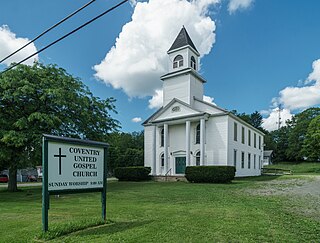
Coventry is a town in Chenango County, New York, United States. The population was 1,655 at the 2010 census. The town is named after Coventry, Connecticut, by settlers from New England. Coventry is in the southern part of Chenango County and is northeast of Binghamton.

<span class="mw-page-title-main">McDonough, New York</span> Town in New York, United States

McDonough is a town in Chenango County, New York, United States. The population was 886 at the 2010 census. The town is named after Thomas Macdonough, a naval officer who served on Lake Champlain and other locations. McDonough is located in the western part of Chenango County, west of Norwich.

<span class="mw-page-title-main">North Norwich, New York</span> Town in New York, United States

North Norwich is a town in Chenango County, New York, United States. The population was 1,783 at the 2010 census. The town is directly north of the City of Norwich in the eastern half of the county.

<span class="mw-page-title-main">Pharsalia, New York</span> Town in New York, United States

Pharsalia is a town in Chenango County, New York, United States. The population was 593 at the 2010 census. The town was named after Pharsalia, which is a commonly accepted name of the decisive battle in the Great Roman Civil War, where Julius Caesar defeated Pompey in 48 BCE.

<span class="mw-page-title-main">Plymouth, New York</span> Town in New York, United States

Plymouth is a town in Chenango County, New York, United States. The population was 1,804 at the 2010 census. It is an interior town in the northern part of the county. The town is northwest of the city of Norwich. Plymouth was also known as Plymouth Rock.

<span class="mw-page-title-main">Preston, New York</span> Town in New York, United States

Preston is a town in Chenango County, New York, United States. The population was 1,044 at the 2010 census. Preston is an interior town of Chenango County and is west of the city of Norwich.

<span class="mw-page-title-main">Earlville, New York</span> Village in New York, United States

Earlville is a village in New York state bisected by two counties: Madison County and Chenango County, United States. The population was 774 as per the 2020 Decennial census, a decrease from the 872 reported in the 2010 census. The village is named after Jonas Earl, a canal commissioner.

<span class="mw-page-title-main">Binghamton (town), New York</span> Town in New York, United States

Binghamton is a town in Broome County, New York, United States. The population was 4,623 at the 2020 census. The town is named after an early developer, William Bingham.

Afton is a village in Chenango County, New York, United States. The population was 822 at the 2010 census. The village is named after the poem "Sweet Afton" by Scottish poet Robert Burns, referring to the River Afton in Ayrshire, Scotland.

<span class="mw-page-title-main">Bainbridge (village), New York</span> Village in New York, United States

Bainbridge is a village in Chenango County, New York, United States. The population was 1,355 at the 2010 census. The village is at the center of the town of Bainbridge and lies between Binghamton and Oneonta.

<span class="mw-page-title-main">Bainbridge, New York</span> Town in New York, United States

Bainbridge is a town in Chenango County, New York, United States. The population was 3,308 at the 2010 census. The town is at the eastern border of Chenango County, halfway between Binghamton and Oneonta.

<span class="mw-page-title-main">Greene (village), New York</span> Village in New York, United States

Greene is a village in Chenango County, New York, United States. The population was 1,580 at the 2010 census. The village is named after General Nathanael Greene. It is within the town of Greene and is northeast of Binghamton.

New Berlin is a village in Chenango County, New York, United States. The population was 1,028 at the 2010 census. The village is by the eastern town line of the town of New Berlin and is northeast of Norwich.

<span class="mw-page-title-main">New Berlin, New York</span> Town in New York, United States

New Berlin is a town in Chenango County, central New York, United States. The population was 2,682 at the 2010 census. The town contains the village of New Berlin. The town is at the eastern border of the county and is northeast of Norwich.

<span class="mw-page-title-main">Norwich, New York</span> City in New York, United States

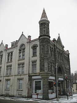
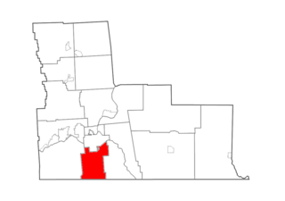
Norwich is a city and county seat of Chenango County, New York, United States. Surrounded on all sides by the Town of Norwich, the city's name is taken from Norwich, England. Its population was 7,051 at the 2020 census.

<span class="mw-page-title-main">Oxford, New York</span> Town in New York, United States

Oxford is a town in Chenango County, New York, United States. The town contains a village also named Oxford. Oxford is an interior town in the south-central part of the county, southwest of the city of Norwich. At the 2010 census the town population was 3,901. The name derives from that of the native town of an early landowner from New England.

<span class="mw-page-title-main">Sherburne (village), New York</span> Village in New York, United States

Sherburne is a village in Chenango County, New York, United States. The population was 1,367 at the 2010 census. It is in the town of Sherburne, north of Norwich.

References

  1. "ArcGIS REST Services Directory". United States Census Bureau. Retrieved September 20, 2022.
  2. 1 2 "Geographic Identifiers: 2010 Demographic Profile Data (G001): Oxford village, New York". U.S. Census Bureau, American Factfinder. Archived from the original on February 12, 2020. Retrieved November 26, 2014.
  3. "Town of Oxford, NY". www.townofoxfordny.com. Retrieved December 8, 2023.
  4. "National Register Information System". National Register of Historic Places . National Park Service. March 13, 2009.
  5. "US Gazetteer files: 2010, 2000, and 1990". United States Census Bureau. February 12, 2011. Retrieved April 23, 2011.
  6. "Census of Population and Housing". Census.gov. Retrieved June 4, 2015.
  7. "Oxford, NY | Data USA". datausa.io. Retrieved December 8, 2023.