
Burlington is the most-populous city in Vermont and the seat of Chittenden County. It is 45 miles (72 km) south of the Canada–United States border and 95 miles (153 km) south of Montreal. The population was 44,743 at the 2020 census. It ranks as the least-populous city to also be the most-populous city in its state.

The Winooski Falls Mill District is located along the Winooski River in the cities of Winooski and Burlington, Vermont, in the United States of America. It encompasses a major industrial area that developed around two sets of falls on the river in the 19th century.

The Poultney Main Street Historic District encompasses the commercial and residential historic core of the village of Poultney, Vermont. Centered on Main Street and East Main Street, between College Avenue and St. Raphael's Catholic Church, the district includes a diversity of architectural styles, as well as civic, religious, and commercial functions spanning a period of more than 100 years. The district was listed on the National Register of Historic Places in 1988.

The Buell Street–Bradley Street Historic District encompasses a small residential area just to the east of downtown Burlington, Vermont. Roughly bounded by Pearl, South Willard, and College Streets, and Orchard Terrace, the area was developed between about 1890 and 1910, representing one of the last significant neighborhoods built up near the downtown area. The district was listed on the National Register of Historic Places in 1995.

The Burlington Traction Company is a historic trolley maintenance facility at Riverside Avenue and North Winooski Avenue in Burlington, Vermont. The property includes two brick trolley barns, built c. 1900 and c. 1910 respectively, that were used as public transit maintenance facilities until 1999, after which they were adaptively repurposed to other residential and commercial uses. The property was listed on the National Register of Historic Places in 2004.

The Downtown Essex Junction Commercial Historic District encompasses the historically railroad-dominated portion of downtown Essex Junction, Vermont. Aligned along the south side of Railroad Avenue and adjacent portions of Main Street, the area underwent most of its development between 1900 and 1940, when Essex Junction served as a major regional railroad hub. The district was listed on the National Register of Historic Places in 2004.
The Dumas Tenements are a pair of four-unit apartment buildings, set back-to-back at 114 West Allen and 114 West Canal Streets in Winooski, Vermont. Built about 1907 by a French Canadian immigrant, they are among the only buildings of their type to survive the city's urban redevelopment efforts of the late 20th century. They were listed on the National Register of Historic Places in 2012.
The Duplex at 73-75 Sherman Street is a historic multiunit residential building in Burlington, Vermont. Built about 1912 as a livery stable, it was adapted into a residential duplex in 1927. It is a good local example of vernacular Colonial Revival architecture, built as worker housing in the growing city. It was listed on the National Register of Historic Places in 2013.

The William Fitzgerald Block is a historic mixed-use commercial and residential building at 57-63 North Champlain Street in Burlington, Vermont. Built about 1887, it is a well-preserved example of a period neighborhood store with residences above. It was listed on the National Register of Historic Places in 2012.

44 Front Street in Burlington, Vermont is a well-preserved vernacular Queen Anne Revival house. Built about 1860 and significantly altered in 1892, it is representative of two periods of the city's growth in the 19th century. It was listed on the National Register of Historic Places in 2008.
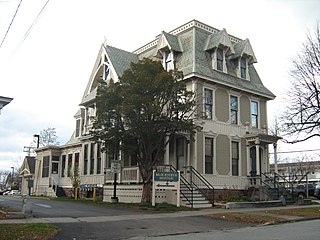
The Martin L. Kelsey House is a historic house at 43 Elmwood Avenue in Burlington, Vermont. Built in 1879 for a local merchant, it is a distinctive and architecturally varied house, with elements of the Second Empire, Queen Anne, and Stick styles on display. It was listed on the National Register of Historic Places in 1983, and now forms part of a senior housing complex.
The LeClair Avenue Historic District encompasses a small residential development on LeClair Avenue and North Street in Winooski, Vermont. Subdivided and developed by Francis LeClair, a prominent local businessman, the well-preserved working-class residences typify development of the period catering to the area's growing French-Canadian immigrant community. The district was listed on the National Register of Historic Places in 1992.

The Lakeside Development, or the Lakeside Historic District, encompasses a historic company-built residential development in southern Burlington, Vermont. Isolated between the Vermont Railway railroad line and Lake Champlain and accessible only via Lakeside Avenue off Pine Street, the area was developed between about 1894 and 1910 by the Queen City Cotton Company, whose mill complex stood just to the east of the railroad line. The district was listed on the National Register of Historic Places in 1982.

The Main Street–College Street Historic District encompasses a historically fashionable residential area of Burlington, Vermont. Principally located along Main and College Streets between South Winooski and South Williams Streets, the area was one of the city's most exclusive residential areas from the early 19th century to the early 20th century, and includes a diversity of high quality architecture from that period. It was listed on the National Register of Historic Places in 1988.

The Plainfield Village Historic District encompasses a significant portion of the village of Plainfield, Vermont. Located in northernmost Plainfield on United States Route 2, the village grew in the 19th century as a mill town and service community for the surround agricultural areas, and has a well-preserved collection of Greek Revival and Italianate architecture. It was listed on the National Register of Historic Places in 1983.

The Pearl Street Historic District of Burlington, Vermont encompasses part of the city's first major east-west transportation arteries, which developed from a fashionable residential area in the early 19th century to its present mixed use. It contains one of the city's highest concentrations of early Federal period architecture, as well as a number of fine Queen Anne and Colonial Revival houses. It was listed on the National Register of Historic Places in 1984.

The Saltus Grocery Store is a historic mixed-use commercial and residential building at 299-301 North Winooski Street in Burlington, Vermont. Built in 1897, it is a well-preserved example of a neighborhood store of the period. It was listed on the National Register of Historic Places in 2001.

The South Union Street Historic District encompasses a historic 19th-century residential neighborhood for the upper middle class in Burlington, Vermont. Developed along South Union Street between Main and Howard Streets, South Union grew between about 1835 and 1938 as a popular area for well-to-do yet middle class Burlingtonians, affording views of Lake Champlain to the west. The architecturally diverse district was listed on the National Register of Historic Places in 1988.

The South Willard Street Historic District encompasses what was once the most fashionable residential area of Burlington, Vermont. Located along South Willard Street between Pearl and Beech Streets, the architecturally heterogeneous area was in the 19th century home to major estates of the city's business leaders, and has since been infilled with a variety of late 19th and early 20th century architecture. The district was listed on the National Register of Historic Places in 1988.

The Maple Street–Clarks Avenue Historic District encompasses a historic 19th-century immigrant neighborhood of St. Johnsbury, Vermont. Located northwest of the downtown area on a sloping hillside, it consists of tenements and single-family houses built for Irish and French Canadian immigrants, sometimes grouped in ways that facilitated the support of large extended families. The district was listed on the National Register of Historic Places in 1994.


