
Burlington is the most-populous city in Vermont and the seat of Chittenden County. It is 45 miles (72 km) south of the Canada–United States border and 95 miles (153 km) south of Montreal. The population was 44,743 at the 2020 census. It ranks as the least-populous city to also be the most-populous city in its state.

The Union Station building is located at 1 Main Street in Burlington, Vermont. The building, last used by the Rutland Railroad as a railroad passenger station in 1953, is owned by Main Street Landing Company and houses offices and art studios.

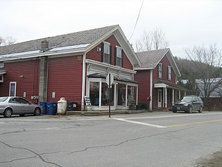
The Poultney Main Street Historic District encompasses the commercial and residential historic core of the village of Poultney, Vermont. Centered on Main Street and East Main Street, between College Avenue and St. Raphael's Catholic Church, the district includes a diversity of architectural styles, as well as civic, religious, and commercial functions spanning a period of more than 100 years. The district was listed on the National Register of Historic Places in 1988.

The Wallingford Main Street Historic District encompasses the historic portions of the village of Wallingford, Vermont. An essentially linear district extending along Main Street on either side of School Street, it has a well-preserved array of 19th and early-20th century residential, commercial, and civic buildings. It was listed on the National Register of Historic Places in 1984.

The Vergennes Historic District encompasses the historic commercial and industrial heart of the city of Vergennes, Vermont. Incorporated in 1788, the city developed as a major industrial center, and served as a military center during the War of 1812. The district includes mainly 19th and early-20th century commercial, retail, residential and civic properties, as well as the former site of the Monkton Iron Works, once one of the nation's largest iron foundries. The district was listed on the National Register of Historic Places in 1976.

Grasse Mount is a campus building of the University of Vermont (UVM), which is located on 411 Main Street in Burlington, Vermont. Built in 1804 for Captain Thaddeus Tuttle (1758–1836), a local merchant, the building was designed by architect and surveyor John Johnson and constructed by carpenter Abram Stevens. By 1824, Tuttle had lost his fortune and sold the property to Vermont Governor Cornelius Van Ness. Named after French Admiral, François Joseph Paul de Grasse "Grasse Mount" was added to the National Register of Historic Places on April 11, 1973.

The Terraces Historic District encompasses a historic late 19th and early 20th-century residential area of White River Junction, Vermont. The district, developed as an upper middle-class residential area beginning in 1880, features a variety of architectural styles encapsulating the community's growth through about 1930. It was listed on the National Register of Historic Places in 2012.

The Battery Street Historic District encompasses one of the oldest developed areas of Burlington, Vermont. With a history dating to 1790, this area, south of downtown Burlington and initially bounded roughly by Main, St. Paul, and Maple Streets, and Lake Champlain, this area includes a mix of residential, commercial, and industrial uses, with architecture spanning from its early period to the 20th century, including one of the city's oldest houses. The district was listed on the National Register of Historic Places in 1977, and has twice been enlarged, extending west to South Union Street.

The Buell Street–Bradley Street Historic District encompasses a small residential area just to the east of downtown Burlington, Vermont. Roughly bounded by Pearl, South Willard, and College Streets, and Orchard Terrace, the area was developed between about 1890 and 1910, representing one of the last significant neighborhoods built up near the downtown area. The district was listed on the National Register of Historic Places in 1995.

The Burlington Breakwater is a breakwater providing shelter to the harbor of Burlington, Vermont from the open waters of Lake Champlain. It was built in several stages between 1836 and 1890, and is a rare example of a 19th-century timber-cribbed stone breakwater. It was listed on the National Register of Historic Places in 2003.
The Charlotte Center Historic District encompasses the historic 19th-century town center of Charlotte, Vermont. Settled c. 1790 and developed mainly in the mid-19th century, the village, stretched along Church Hill Road west of Hinesburg Road, retains a well-preserved 19th-century atmosphere of residential, civic, and commercial buildings. The district was listed on the National Register of Historic Places in 1984.

The City Hall Park Historic District encompasses one of the central economic, civic, and public spaces of the city of Burlington, Vermont. Centered on City Hall Park, the area's architecture encapsulates the city's development from a frontier town to an urban commercial center. The district was listed on the National Register of Historic Places in 1983.

The Lakeside Development, or the Lakeside Historic District, encompasses a historic company-built residential development in southern Burlington, Vermont. Isolated between the Vermont Railway railroad line and Lake Champlain and accessible only via Lakeside Avenue off Pine Street, the area was developed between about 1894 and 1910 by the Queen City Cotton Company, whose mill complex stood just to the east of the railroad line. The district was listed on the National Register of Historic Places in 1982.

The Main Street–College Street Historic District encompasses a historically fashionable residential area of Burlington, Vermont. Principally located along Main and College Streets between South Winooski and South Williams Streets, the area was one of the city's most exclusive residential areas from the early 19th century to the early 20th century, and includes a diversity of high quality architecture from that period. It was listed on the National Register of Historic Places in 1988.

The North Street Historic District encompasses the traditional commercial area serving the residential Old North End neighborhood of Burlington, Vermont. It extends for ten blocks along North Street between North Avenue and North Winooski Avenue, and has served as the neighborhood's commercial center for over 150 years. It was listed on the National Register of Historic Places in 2001.

The Pearl Street Historic District of Burlington, Vermont encompasses part of the city's first major east-west transportation arteries, which developed from a fashionable residential area in the early 19th century to its present mixed use. It contains one of the city's highest concentrations of early Federal period architecture, as well as a number of fine Queen Anne and Colonial Revival houses. It was listed on the National Register of Historic Places in 1984.

The Robarge-Desautels Apartment House is a historic multi-unit residence at 54 North Champlain Street in Burlington, Vermont. Built about 1900, it is a well-preserved example of a Queen Anne style apartment house. It was listed on the National Register of Historic Places in 2014.

The South Willard Street Historic District encompasses what was once the most fashionable residential area of Burlington, Vermont. Located along South Willard Street between Pearl and Beech Streets, the architecturally heterogeneous area was in the 19th century home to major estates of the city's business leaders, and has since been infilled with a variety of late 19th and early 20th century architecture. The district was listed on the National Register of Historic Places in 1988.

The Railroad Street Historic District encompasses a cluster of commercial and railroad-related buildings at the traditional late 19th-century heart of St. Johnsbury, Vermont. It includes five commercial buildings and the town's 1883 union depot, and is reflective of the town's importance as a major railroad junction in northern New England. The district was listed on the National Register of Historic Places in 1974. It was subsumed by the larger St. Johnsbury Historic District in 1980.
The Pine Street Industrial Historic District encompasses a collection of maritime industrial buildings and archaeological sites in southern Burlington, Vermont. The district includes buildings across nearly 100 years, encompassing the development and decline of the area, which served as a major railroad and shipping terminus from the mid-19th to mid-20th centuries. It was listed on the National Register of Historic Places in 1984.


