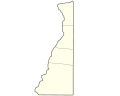
Ohio County is a county located in the Northern Panhandle of the U.S. state of West Virginia. As of the 2020 census, the population was 42,425. Its county seat is Wheeling. The county was formed in 1776 from the District of West Augusta, Virginia. It was named for the Ohio River, which forms its western boundary with the state of Ohio. West Liberty was designated as the county seat in 1777, serving to 1797.

Wetzel County is a county in the U.S. state of West Virginia. As of the 2020 census, the population was 14,442. Its county seat is New Martinsville. The county, founded in 1846, is named for Lewis Wetzel, a famous frontiersman and Indian fighter. Its northern border aligns with the Mason-Dixon line, but is to the west of the line's western terminus.

Marshall County is a county in the U.S. state of West Virginia. At the 2020 census, the population was 30,591. Its county seat is Moundsville. With its southern border at what would be a continuation of the Mason-Dixon line to the Ohio River, it forms the base of the Northern Panhandle of West Virginia.
Hancock County is a county in the U.S. state of West Virginia. As of the 2020 census, the population was 29,095. Its county seat is New Cumberland and its largest city is Weirton. The county was created from Brooke County in 1848 and named for John Hancock, first signer of the Declaration of Independence. Located at the tip of the state's Northern Panhandle, Hancock County is the northernmost point in both West Virginia and, by some definitions, the Southern United States. Hancock County is part of the Weirton-Steubenville, WV-OH Metropolitan Statistical Area, which is also included in the Pittsburgh-New Castle-Weirton, PA-WV-OH Combined Statistical Area.
Brooke County is a county in the Northern Panhandle of the U.S. state of West Virginia. As of the 2020 census, the population was 22,559. Its county seat is Wellsburg. The county was created in 1797 from part of Ohio County and named in honor of Robert Brooke, Governor of Virginia from 1794 to 1796. Brooke County is part of the Weirton-Steubenville, WV-OH Metropolitan Statistical Area, which is also included in the Pittsburgh-New Castle-Weirton, PA-WV-OH Combined Statistical Area.

Scouting in West Virginia has a long history, from the 1910s to the present day, serving thousands of youth in programs that suit the environment in which they live.
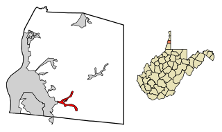
Triadelphia is a town in Ohio County, West Virginia, United States. It is part of the Wheeling, West Virginia Metropolitan Statistical Area. The population was 669 at the 2020 census.

Wheeling is a city in the U.S. state of West Virginia. Located almost entirely in Ohio County, of which it is the county seat, it lies along the Ohio River in the foothills of the Appalachian Mountains and also contains a tiny portion extending into Marshall County. Wheeling is located about 60 miles (96 km) west of Pittsburgh and is the principal city of the Wheeling metropolitan area. As of the 2020 census, the city had a population of 27,062, and the metro area had a population of 139,513. It is the fifth-largest city in West Virginia, and the largest in the state’s Northern Panhandle.

The eastern panhandle is one of the two panhandles in the U.S. state of West Virginia; the other is the northern panhandle. It is a small stretch of territory in the northeast of the state, bordering Maryland and Virginia. Some sources and regional associations only identify the eastern panhandle as being composed of Morgan, Berkeley, and Jefferson counties. Berkeley and Jefferson counties are geographically located in the Shenandoah Valley. West Virginia is the only U.S. state with two panhandles.

Yohogania County was created by the new state of Virginia in 1776, in an area long disputed between Virginia and Pennsylvania. The county ceased to exist after the border dispute between the two states was resolved in the 1780s. Thus, it is sometimes referred to as a "lost county," although 1.5 million people live within the territory it once claimed, which encompasses two entire counties and parts of four others in two states.
The District of West Augusta was a short-lived (1774–76) historical region of Colonial Virginia that encompassed much of what is now northern West Virginia and southwestern Pennsylvania.

West Virginia's 1st congressional district is currently located in the southern half of the state.

West Virginia Route 88 is a north–south state highway located within the Northern Panhandle of West Virginia. The southern terminus is at U.S. Route 250 in Limestone. The northern terminus is at West Virginia Route 27 five miles east of Wellsburg and 400 yards (370 m) west of the Pennsylvania border.

Greater Pittsburgh is the metropolitan area surrounding the city of Pittsburgh in Western Pennsylvania, United States. The region includes Allegheny County, Pittsburgh's urban core county and economic hub, and seven adjacent Pennsylvania counties: Armstrong, Beaver, Butler, Fayette, Lawrence, Washington, and Westmoreland in Western Pennsylvania, which constitutes the Pittsburgh, PA Metropolitan Statistical Area MSA as defined by the U.S. Census Bureau.
Transport in the U.S. state of West Virginia is handled by the West Virginia Department of Transportation (WVDOT) which employs more than 6,000 in West Virginia.

Wheeling Creek is a tributary of the Ohio River, 25 miles (40 km) long, in the Northern Panhandle of West Virginia in the United States, with a watershed extending into southwestern Pennsylvania. Via the Ohio River, it is part of the watershed of the Mississippi River, draining an area of approximately 300 square miles (780 km2) on the unglaciated portion of the Allegheny Plateau. It flows into the Ohio River in downtown Wheeling, just downstream of Ohio's Wheeling Creek on the opposite bank. A variant name is Big Wheeling Creek. According to the French explorer Pierre Joseph Céloron de Blainville, the native name of the stream is the Kanououara River, as was inscribed on the lead plate buried at the mouth by the Ohio River in 1749.
The Wheeling, WV-OH Metropolitan Statistical Area, as defined by the United States Census Bureau, is an area consisting of two counties in the Northern Panhandle of West Virginia and one in eastern Ohio, anchored by the city of Wheeling. As of the 2010 census, the MSA had a population of 147,950. This represents a decline of 3.4% from the 2000 census population of 153,172.

The Weirton–Steubenville, WV–OH Metropolitan Statistical Area, also known as the Upper Ohio Valley, is a metropolitan statistical area consisting of two counties in the Northern Panhandle of West Virginia and one in Ohio, anchored by the cities of Weirton and Steubenville. As of the 2020 census, the MSA had a population of 116,903. This puts it at 334th largest in the United States. It is also included in the larger Pittsburgh–New Castle–Weirton, PA–OH–WV Combined Statistical Area.
Thomas Sweeny or Sweeney was a prominent glass manufacturer in what became Wheeling, West Virginia during the American Civil War, who before that war served in both houses of the Virginia General Assembly and ran the North Wheeling Flint Glass Works.