Northwood, North Dakota

Last updated

Northwood, North Dakota
Northwood, North Dakota.jpg
The Northwood grain elevators
Motto: 
"Come Discover Northwood This is the place for you!"
ND Grand Forks County Northwood.svg
Location of Northwood, North Dakota
Coordinates: 47°44′5″N97°34′8″W / 47.73472°N 97.56889°W / 47.73472; -97.56889
CountryUnited States
State North Dakota
County Grand Forks
Metro Greater Grand Forks
Founded1884
Government
  MayorKarl Broeren
Area
[1]
  Total1.21 sq mi (3.13 km2)
  Land1.21 sq mi (3.13 km2)
  Water0.00 sq mi (0.00 km2)
Elevation
[2]
1,116 ft (340 m)
Population
 (2020)
  Total982
  Density812.24/sq mi (313.71/km2)
Time zone UTC-6 (CST)
  Summer (DST) UTC-5 (CDT)
ZIP code
58267
Area code 701
FIPS code 38-58300
GNIS feature ID1036204 [2]
Website discovernorthwood.com

Northwood is a city in Grand Forks County, North Dakota, United States. It is part of the "Grand Forks, ND-MN Metropolitan Statistical Area" or "Greater Grand Forks." The population was 982 at the 2020 census. [3]

Contents

History

Northwood was founded in 1884.

A tornado, rated EF4 on the Enhanced Fujita Scale, [4] struck Northwood on the evening of August 26, 2007 causing destruction to the entire town and killing one person. [5] Later on some of the buildings were burned, collapsed, or torn down because of severe damage to the buildings from the tornado. [6] [7] [8]

Geography

According to the United States Census Bureau, the city has a total area of 1.27 square miles (3.29 km2), all land. [9]

Demographics

Historical population
CensusPop.Note
1890 268
1900 697160.1%
1910 76910.3%
1920 93521.6%
1930 9713.9%
1940 1,06810.0%
1950 1,18210.7%
1960 1,1951.1%
1970 1,189−0.5%
1980 1,2404.3%
1990 1,166−6.0%
2000 959−17.8%
2010 945−1.5%
2020 9823.9%
2021 (est.)964 [10] −1.8%
U.S. Decennial Census [11]
2020 Census [3]

Northwood has the highest percentage of Norwegian American ancestry of any city in the United States. [12]

2010 census

As of the census [13] of 2010, there were 945 people, 397 households, and 243 families living in the city. The population density was 744.1 inhabitants per square mile (287.3/km2). There were 443 housing units at an average density of 348.8 per square mile (134.7/km2). The racial makeup of the city was 98.0% White, 0.1% African American, 0.1% Native American, 0.2% Asian, 0.1% from other races, and 1.5% from two or more races. Hispanic or Latino of any race were 0.4% of the population.

There were 397 households, of which 27.5% had children under the age of 18 living with them, 49.4% were married couples living together, 6.3% had a female householder with no husband present, 5.5% had a male householder with no wife present, and 38.8% were non-families. 36.8% of all households were made up of individuals, and 20.7% had someone living alone who was 65 years of age or older. The average household size was 2.23 and the average family size was 2.91.

The median age in the city was 45.3 years. 23.6% of residents were under the age of 18; 5.3% were between the ages of 18 and 24; 20.6% were from 25 to 44; 24% were from 45 to 64; and 26.6% were 65 years of age or older. The gender makeup of the city was 50.2% male and 49.8% female.

2000 census

As of the census of 2000, there were 959 people, 408 households, and 243 families living in the city. The population density was 923.1 inhabitants per square mile (356.4/km2). There were 459 housing units at an average density of 441.8 per square mile (170.6/km2). The racial makeup of the city was 99.17% White, 0.10% African American, 0.10% Native American, 0.10% Asian, 0.10% from other races, and 0.42% from two or more races. Hispanic or Latino of any race were 0.73% of the population.

Of the 408 households, 25.0% had children under the age of 18 living with them, 53.2% were married couples living together, 4.4% had a female householder with no husband present, and 40.2% were non-families. 38.2% of all households were made up of individuals, and 22.3% had someone living alone who was 65 years of age or older. The average household size was 2.17 and the average family size was 2.85.

In the city, the population was spread out, with 20.8% under the age of 18, 4.4% from 18 to 24, 22.3% from 25 to 44, 24.6% from 45 to 64, and 27.9% who were 65 years of age or older. The median age was 48 years. For every 100 females, there were 91.0 males. For every 100 females age 18 and over, there were 81.0 males.

The median income for a household in the city was $33,000, and the median income for a family was $41,667. Males had a median income of $31,389 versus $21,389 for females. The per capita income for the city was $17,923. About 2.8% of families and 5.8% of the population were below the poverty line, including 2.4% of those under age 18 and 8.3% of those age 65 or over.

Related Research Articles

<span class="mw-page-title-main">Sharkey County, Mississippi</span> County in Mississippi, United States

Sharkey County is a county located in the U.S. state of Mississippi. Part of the eastern border is formed by the Yazoo River. According to the 2020 census, the population was 3,800, making it the second-least populous county in Mississippi, after Issaquena County. Its county seat is Rolling Fork. The county is named after William L. Sharkey, the provisional Governor of Mississippi in 1865.

<span class="mw-page-title-main">Cordova, Alabama</span> City in Alabama, United States

Cordova is a city in Walker County, Alabama, United States. It was formerly a textile mill town. It was incorporated in 1897. At the 2010 census the population was 2,095, down from 2,423 in 2000.

<span class="mw-page-title-main">Pembroke, Georgia</span> City and County Seat in Georgia, United States

Pembroke is a city and county seat in Bryan County, Georgia, United States. As of the 2020 census, the population of the city was 2,513. It is located approximately 35 miles west of Savannah, Georgia, and approximately 20 miles south of Statesboro, Georgia.

<span class="mw-page-title-main">Gilbertville, Iowa</span> City in Iowa, United States

Gilbertville is a city in Black Hawk County, Iowa, United States. The population was 794 at the time of the 2020 census. It is part of the Waterloo–Cedar Falls Metropolitan Statistical Area.

<span class="mw-page-title-main">Anita, Iowa</span> City in Iowa, United States

Anita is a city in Cass County, Iowa, United States, platted in 1869 and incorporated in 1875. The population was 963 at the 2020 census. Lake Anita State Park is located just outside the town.

<span class="mw-page-title-main">Ryan, Iowa</span> City in Iowa, United States

Ryan is a city in Delaware County, Iowa, United States. The population was 350 at the time of the 2020 census.

<span class="mw-page-title-main">Thurman, Iowa</span> City in Iowa, United States

Thurman is a city in Fremont County, Iowa. As of the 2020 census, the city population was 167.

<span class="mw-page-title-main">Northboro, Iowa</span> City in Iowa, United States

Northboro is a city in Page County, Iowa, United States. The population was 52 at the time of the 2020 census.

<span class="mw-page-title-main">Northwood, Iowa</span> City in Iowa, United States

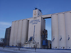
Northwood is a city in Worth County, Iowa, United States, along the Shell Rock River. The population was 2,072 at the time of the 2020 census. It is the county seat of Worth County.

<span class="mw-page-title-main">Ashby, Minnesota</span> City in Minnesota, United States

Ashby is a city in northeastern Grant County, Minnesota, United States. The population was 469 at the 2020 census.

<span class="mw-page-title-main">Silver City, Mississippi</span> Town in Mississippi, United States

Silver City is a town in Humphreys County, Mississippi, United States. The population was 217 at the 2021 census, a massive decline from the 2000 census.

<span class="mw-page-title-main">Rolling Fork, Mississippi</span> City and county seat in Mississippi, United States

Rolling Fork is a city and county seat of Sharkey County, Mississippi, United States. As of the 2020 census, the population of the town was 1,883.

<span class="mw-page-title-main">Duquesne, Missouri</span> City in Missouri, United States

Duquesne is a Fourth-Class City in Jasper County, Missouri, United States. The population was 2,159 at the 2020 census. It is part of the Joplin, Missouri Metropolitan Statistical Area.

<span class="mw-page-title-main">Worth, Missouri</span> Village in Missouri, United States

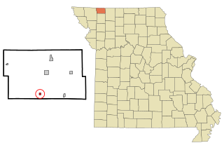
Worth is a village in Worth County, Missouri, United States. The population was 63 at the 2010 census.

<span class="mw-page-title-main">Emerado, North Dakota</span> City in North Dakota, United States

Emerado is a city in Grand Forks County, North Dakota, United States located near Grand Forks Air Force Base. It is part of the "Grand Forks, ND-MN Metropolitan Statistical Area" or "Greater Grand Forks". The population was 443 at the 2020 census. Grand Forks Air Force Base is located near Emerado.

<span class="mw-page-title-main">Shelby, Ohio</span> City in Ohio, United States

Shelby is a city in Richland County in the U.S. state of Ohio, northwest of the city of Mansfield. It is part of the Mansfield, Ohio Metropolitan Statistical Area. The population was 9,282 as of the 2020 census.

<span class="mw-page-title-main">Millbury, Ohio</span> Village in Ohio, United States

Millbury is a village in Wood County, Ohio, United States. The population was 1,193 at the 2020 census.

<span class="mw-page-title-main">Bethel Acres, Oklahoma</span> Town in Oklahoma, United States

Bethel Acres is a town in Pottawatomie County, Oklahoma. The population was 2,895 at the time of the 2010 census, an increase of 5.9 percent from the figure of 2,735 in 2000. It is primarily a bedroom community for people who work in the three nearby larger cities of Shawnee, Tecumseh and Oklahoma City.

<span class="mw-page-title-main">Reynolds, North Dakota</span> City in North Dakota, United States

Reynolds is a city in Grand Forks and Traill counties in the State of North Dakota. It is part of the Grand Forks, ND-MN Metropolitan Statistical Area or "Greater Grand Forks". The population was 277 at the 2020 census. Reynolds, named for pioneer settler Dr. Henry Reynolds, was founded in 1881.

<span class="mw-page-title-main">Black Earth, Wisconsin</span> Village in Wisconsin, United States

Black Earth is a village in Dane County, Wisconsin, United States. The population was 1,338 at the 2010 census. The village is located within the Town of Black Earth. It is part of the Madison Metropolitan Statistical Area.

References

  1. "ArcGIS REST Services Directory". United States Census Bureau. Retrieved September 20, 2022.
  2. 1 2 U.S. Geological Survey Geographic Names Information System: Northwood, North Dakota
  3. 1 2 "Explore Census Data". United States Census Bureau . Retrieved April 18, 2022.
  4. "Northwood North Dakota Tornado Rated EF4". National Weather Service Forecast Office - Grand Forks, ND. August 30, 2007. Retrieved August 30, 2007.
  5. Bakken, Ryan (August 27, 2007). "At least one believed killed in Northwood tornado". Grand Forks Herald . Retrieved August 27, 2007.[ dead link ]
  6. "Tornado timeline". www.facebook.com. Retrieved February 5, 2018.
  7. "Tornado video". www.facebook.com. Retrieved February 5, 2018.
  8. "About 800 photos of Northwood the day after the tornado hit". Archived from the original on May 12, 2008. Retrieved February 5, 2018.
  9. "US Gazetteer files 2010". United States Census Bureau. Archived from the original on January 12, 2012. Retrieved June 14, 2012.
  10. "City and Town Population Totals: 2020-2021". United States Census Bureau. June 27, 2022. Retrieved June 27, 2022.
  11. United States Census Bureau. "Census of Population and Housing" . Retrieved July 20, 2013.
  12. Ancestry By City,.
  13. "U.S. Census website". United States Census Bureau . Retrieved June 14, 2012.