
Bedford St Johns is one of two railway stations in Bedford in Bedfordshire, England, on the Marston Vale Line linking Bletchley and Bedford. It is unstaffed and is operated by London Northwestern Railway.

Fenny Stratford is a railway station that serves the Fenny Stratford area of Milton Keynes, Buckinghamshire. It is on the Marston Vale Line that links Bletchley and Bedford, about one mile east of Bletchley railway station.

The Varsity Line was the main railway route that once linked the English university cities of Oxford and Cambridge, operated by the London and North Western Railway.

Sandy railway station serves the town of Sandy in Bedfordshire, England. It is on the East Coast Main Line, about 44 miles (71 km) from London King's Cross. Sandy is managed and served by Great Northern.

Dunstable Town, also known as Dunstable Church Street, was a railway station on the Great Northern Railway's branch line from Welwyn which served Dunstable in Bedfordshire from 1858 to 1965. Against a background of falling passenger numbers and declining freight returns, the station closed to passengers in 1965 and to goods in 1964, a casualty of the Beeching Axe. The station site is now in use as part of the Luton to Dunstable Busway.

Claydon railway station is a former railway station on the 'Varsity Line', that served the village of Steeple Claydon in Buckinghamshire.
Lord's Bridge was a railway station on the Varsity Line which ran between Oxford and Cambridge. Situated in the north of the parish of Harlton on the western outskirts of Cambridge, it was the penultimate station before the line's eastern terminus at Cambridge. The station opened in 1862 and closed more than a century later in 1968. The site is now part of the Mullard Radio Astronomy Observatory, which includes several rail-mounted radio-telescopes.

Gamlingay railway station was a railway station on the Varsity Line which served the small village of Gamlingay in Cambridgeshire, England. The station opened in 1862 and was located in a rural area that saw little passenger traffic; it closed together with the line in 1968.

Potton was a railway station on the Varsity Line which served the small town of the same name in Bedfordshire. Opened in 1857 as part of Sir William Peel's Sandy and Potton Railway, the station was initially situated further south near the Biggleswade Road. Upon being taken over by the Bedford and Cambridge Railway in 1862 a new station was opened which remained in service for over one hundred years before closing in 1968. The station building has survived and is now a private house.

Winslow railway station is a former railway station which served the town of Winslow in north Buckinghamshire, England. It is on a disused section of the Varsity Line; a single track remains in place but is rusted and overgrown far beyond use. The site of the original station is mostly covered by a small housing development, and although the platforms still remain, they are in a very poor state. In 2014 it was anticipated that the station would reopen on a different site in 2019 as part of East West Rail. In September 2016, Buckinghamshire County Council purchased a site for a new station, beside the A413 bridge. In October 2020, the East West Rail Alliance announced that work will start on the new station in summer 2022.
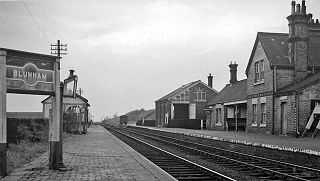
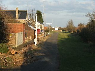
Blunham was a railway station on the Varsity Line which served the small village of the same name in Bedfordshire. Opened in 1862, the station was located in a rural area and saw little passenger traffic; it closed together with the line in 1968.
Willington was a railway station on the Varsity Line which served the small village of the same name in Bedfordshire. Opened in 1903, the station was located in a rural area and saw little passenger traffic; it closed together with the line in 1968.
Kempston & Elstow Halt was a railway station on the Varsity Line which served the Bedfordshire town of Kempston in England. Opened in 1905, it was closed temporarily during both world wars and did not reopen after 1941, being officially closed in 1949.

Alvescot railway station was a railway station between the Oxfordshire villages of Alvescot and Black Bourton, in England. It was Oxford, Witney and Fairford Railway between Oxford and Fairford.
Stanbridgeford railway station on the London and North Western Railway's branch line to Dunstable served the Bedfordshire villages of Stanbridge, Totternhoe, Eaton Bray and Tilsworth from 1849 to 1964. Once popular with visitors to the nearby Totternhoe Knolls and ramblers, the station closed against a background of falling passenger numbers and declining freight returns. The station building has survived into private ownership, but a section of the alignment to the east and west of the site has been taken into the A505 Leighton Southern Bypass. National Cycle Network route 6 runs to the east over the bypass as far as the outskirts of Dunstable.
Olney was a railway station on the former Bedford to Northampton Line and Stratford-upon-Avon and Midland Junction Railway which served the town of Olney in Buckinghamshire, England. It was situated on a busy section of line between Towcester and Ravenstone Wood junction which saw heavy use by freight services running between Wales and north-east England. The station closed for passengers in 1962 and completely in 1964, the various connecting routes to the line having closed one by one from the 1950s onwards.

Witney railway station served the Oxfordshire town of Witney on the Oxford, Witney and Fairford Railway line. It consisted of two stone-built platforms, a station building, a signal box, and a shed in the form of a pagoda.

Eynsham railway station served the Oxfordshire village of Eynsham and the Eynsham Sugar Beet Factory on the Oxford, Witney and Fairford Railway between Oxford and Witney.
Northampton St. John's Street was a railway station and the northern terminus of the Midland Railway's former Bedford to Northampton Line which served the English county town of Northampton from 1872 to 1939. Its closure came about as a cost-cutting measure implemented by the London, Midland and Scottish Railway which diverted services to the nearby Northampton Castle station. After closure the elegant station building was used as offices and the line for the storage of rolling stock; the site was cleared in 1960 to make way for a car park. The car park has now been built on and is the location of St Johns Halls of Residence for The University of Northampton.

Lechlade railway station served the small town of Lechlade in Gloucestershire, England. The station was on the Oxford, Witney and Fairford Railway, between Oxford and Fairford, it was built where the line crossed the road to Burford, 0.5 miles (0.80 km) north of Lechlade.
