
The Birmingham and Fazeley Canal is a canal of the Birmingham Canal Navigations in the West Midlands of England. Its purpose was to provide a link between the Coventry Canal and Birmingham and thereby connect Birmingham to London via the Oxford Canal.
Birmingham Canal Navigations (BCN) is a network of canals connecting Birmingham, Wolverhampton, and the eastern part of the Black Country. The BCN is connected to the rest of the English canal system at several junctions. It was owned and operated by the Birmingham Canal Navigation Company from 1767 to 1948.

The Shropshire Union Canal, sometimes nicknamed the "Shroppie", is a navigable canal in England. The Llangollen and Montgomery canals are the modern names of branches of the Shropshire Union (SU) system and lie partially in Wales.

The Worcester and Birmingham Canal is a canal linking Birmingham and Worcester in England. It starts in Worcester, as an 'offshoot' of the River Severn and ends in Gas Street Basin in Birmingham. It is 29 miles (47 km) long. There are 58 locks in total on the canal, including the 30 Tardebigge Locks, one of the longest lock flights in Europe. The canal climbs 428 feet (130 m) from Worcester to Birmingham.

The Smethwick Engine is a Watt steam engine made by Boulton and Watt, which was installed near Birmingham, England, and was brought into service in May 1779. Now at Thinktank, Birmingham Science Museum, it is the oldest working steam engine and the oldest working engine in the world.
The Warwickshire ring is a connected series of canals forming a circuit around the West Midlands area of England. The ring is formed from the Coventry Canal, the Oxford Canal, the Grand Union Canal, the Stratford-upon-Avon Canal and the Birmingham and Fazeley Canal. It is a popular route with tourists due to its circular route and mixture of urban and rural landscapes.
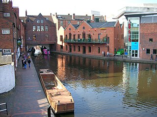
Gas Street Basin is a canal basin in the centre of Birmingham, England, where the Worcester and Birmingham Canal meets the BCN Main Line. It is located on Gas Street, off Broad Street, and between the Mailbox and Brindleyplace canal-side developments.

Aston Junction is the name of the canal junction where the Digbeth Branch Canal terminates and meets the Birmingham and Fazeley Canal near to Aston, Birmingham, England.

The current Cannock Extension Canal is a 1.8-mile (2.9 km) canal in England. It runs from Pelsall Junction on the Wyrley and Essington Canal, north to Norton Canes Docks and forms part of the Birmingham Canal Navigations. Historically, it ran to Hednesford, and served a number of collieries, which provided the main traffic. It opened in 1863, and the northern section closed in 1963, as a result of mining subsidence.
The BCN Main Line, or Birmingham Canal Navigations Main Line is the evolving route of the Birmingham Canal between Birmingham and Wolverhampton in England.

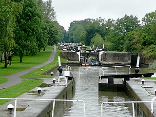
The Birmingham Canal Navigations (BCN), a network of narrow canals in the industrial midlands of England, is built on various water levels. The three longest are the Wolverhampton, Birmingham, and Walsall levels. Locks allow boats to move from one level to another.

The Walsall Canal is a narrow canal, seven miles (11 km) long, forming part of the Birmingham Canal Navigations, and passing around the western side of Walsall, West Midlands, England.
Rushall Junction is the southern limit of the Rushall Canal where it meets the Tame Valley Canal in the West Midlands, England. It opened in 1847, when the Rushall Canal was built to create connections between the Birmingham Canal Navigations system and the Wyrley and Essington Canal, following the amalgamation of the two companies in 1840.

Tame Valley Junction, also known as Doe Bank Junction, is a canal junction at the western limit of the Tame Valley Canal where it meets the Walsall Canal, south of Walsall, in the West Midlands, England.

Horseley Fields Junction is a canal junction at the western limit of the Wyrley and Essington Canal where it meets the BCN Main Line, at Horseley Fields east of Wolverhampton, in the West Midlands, England.

Catshill Junction is a canal junction at the northern limit of the Daw End Branch Canal where it meets the Wyrley and Essington Canal main line, near Brownhills, in West Midlands, England.

Birchills Junction is the canal junction at the northern limit of what is now called the Walsall Canal where it meets the Wyrley and Essington Canal main line, near Walsall, West Midlands, England. It opened in 1798, but lasted for little more than a year, until it was re-opened in 1841 when a connecting link was built to the Birmingham Canal Navigations' southern route to Walsall.
Bromford Junction is a canal junction at the foot of the Spon Lane Locks where the Spon Lane Locks Branch meets the BCN New Main Line near Oldbury in the West Midlands, England.

The Wednesbury Oak Loop, sometimes known as the Bradley Arm, is a canal in the West Midlands, England. It is part of the Birmingham Canal Navigations (BCN), and was originally part of James Brindley's main line, but became a loop when Thomas Telford's improvements of the 1830s bypassed it by the construction of the Coseley Tunnel. The south-eastern end of the loop was closed and in parts built over, following the designation of the entire loop as "abandoned" in 1954, including the section which was filled in at the beginning of the 1960s to make way for the Glebefields Estate in Tipton.

The Bradley Branch or Bradley Locks Branch was a short canal of the Birmingham Canal Navigations in the West Midlands, England. Completed in 1849, it included nine locks, and had a number of basins which enabled it to service local collieries and industrial sites. The locks were unusual, as they had a single gate at both ends, rather than double gates at the bottom end. The route closed in the 1950s, and the top seven locks were covered over and landscaped.

