Rumer Hill Junction

Last updated

Rumer Hill Junction
Land-fill site - geograph.org.uk - 161731.jpg
Rumer Hill Junction was in the centre left of this landfill site, which is filling the void left by opencast mining.
Specifications
StatusDestroyed
History
Date completed1859
Date closed1953

Rumer Hill Junction (grid reference SJ991090 ) was a canal junction on the Cannock Extension Canal where the Churchbridge Branch left to join the Hatherton Canal. The junction, along with the northern section of the canal was abandoned in 1963. The Churchbridge Branch and Rumer Hill Junction were subsequently obliterated by opencast mining.

Contents

History

Following the amalgamation of the Birmingham Canal Navigations and the Wyrley and Essington Canal in April 1840, [1] the company had constructed a number of extensions to their system, and as they had proved to be profitable, a further programme was begun in 1854. Included in this batch was the Cannock Extension Canal, to run from Pelsall Junction on the Wyrley and Essington to Hednesford, where there were coal mines. [2] The canal was opened from Pelsall Junction to Rumer Hill Junction in 1858, and completed to Hednesford Basin in 1863. [3]

At the start of the extension programme, the Birmingham Canal Navigations and the Staffordshire and Worcestershire Canal agreed to build a link between the Cannock Extension Canal and the Hatherton Branch of the Staffordshire and Worcestershire. It already reached Churchbridge, and the connecting link only required a flight of thirteen locks to accommodate the difference in levels. The land on which the link would be built was purchased jointly by the two companies, but the Staffordshire and Worcestershire Canal seems to have funded the actual construction. The locks were built in 1858 and 1859, but were not used until the opening of the Cannock Extension Canal in 1863. Through much of its life, the junction was busy, with around 12,000 tons per month passing through it and down the locks in 1902. [4]

The date when the Hatherton Branch and the Churchbridge locks ceased to be used is given as 1949 by Hadfield [5] and 1953 by Shill, but in either case, the junction closed around this time. By 1958, a concrete barrier had been built at the top lock of the Churchbridge flight, to prevent loss of water through the locks. [6] The Cannock Extension Canal was increasingly affected by subsidence from the coal mines it served, and the northern section, including Rumer Hill Junction, closed in 1963. [7] The junction and the surrounding canal were destroyed by subsequent open-cast coal mining. [6]

Whilst restoration of the Hatherton Canal is proposed, the restored canal was planned to join the Cannock Extension Canal further south, at Grove Basin, and there were no proposals to restore any of the canals leading to the junction. Subsequent objections to the revised route have resulted in a second new route being planned, which connects to the Lord Hayes Branch of the Wyrley and Essington Canal, rather than the Cannock Extension Canal. [8]

Location

Rumer Hill Junction was situated about halfway along the 4.1-mile (6.6 km) section of the Cannock Extension Canal which was abandoned in 1963, so was about 2 miles (3.2 km) from Hednesford Basin, and 3.6 miles (5.8 km) from Pelsall Junction. [3] The canal was level in both directions, as it was all built on the 473-foot (144 m) Wolverhampton Level of the Birmingham Canal system. [9] The locks of the Churchbridge flight started immediately after the junction. The flight headed to the south-west, while the Extension Canal ran from the north-west to the south-east at this point. Washbrook Lane crossed the Extension Canal just to the south of the junction at High Bridge, and just beyond that was Leacroft Wharf, its entrance crossed by a towpath bridge. It served the Cannock and Leacroft Colliery, to which it was connected by a short tramway, which ran through a tunnel as it left the wharf in 1902. The tunnel had been opened out by 1918. By the time the 1957/1962 map was published, the tramway had been dismantled, Leacroft Wharf was disused, Washbrook Lane had been destroyed to the south of the canal, and only the top lock of the Churchbridge flight remained. [10]

See also

Bibliography

Related Research Articles

<span class="mw-page-title-main">Staffordshire and Worcestershire Canal</span> Canal in the West Midlands, England

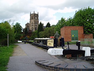
The Staffordshire and Worcestershire Canal is a navigable narrow canal in Staffordshire and Worcestershire in the English Midlands. It is 46 miles (74 km) long, linking the River Severn at Stourport in Worcestershire with the Trent and Mersey Canal at Haywood Junction by Great Haywood.

<span class="mw-page-title-main">Wyrley and Essington Canal</span> Narrow canal in the Midlands, England

The Wyrley and Essington Canal, known locally as "the Curly Wyrley", is a canal in the English Midlands. As built it ran from Wolverhampton to Huddlesford Junction near Lichfield, with a number of branches: some parts are currently derelict. Pending planned restoration to Huddlesford, the navigable mainline now terminates at Ogley Junction near Brownhills. In 2008 it was designated a Local Nature Reserve.

<span class="mw-page-title-main">Birmingham Canal Navigations</span>

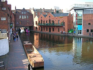
Birmingham Canal Navigations (BCN) is a network of canals connecting Birmingham, Wolverhampton, and the eastern part of the Black Country. The BCN is connected to the rest of the English canal system at several junctions. It was owned and operated by the Birmingham Canal Navigations Company from 1767 to 1948.

<span class="mw-page-title-main">Lichfield Canal</span> English canal under restoration

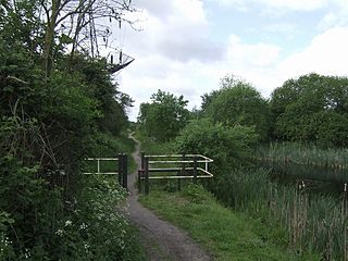
The Lichfield Canal, as it is now known, was historically a part of the Wyrley and Essington Canal, being the section of that canal from Ogley Junction at Brownhills on the northern Birmingham Canal Navigations to Huddlesford Junction, east of Lichfield, on the Coventry Canal, a length of 7 miles (11.3 km). The branch was abandoned in 1955, along with several other branches of the Wyrley and Essington, and much of it was filled in.

<span class="mw-page-title-main">Hatherton Canal</span> Derelict canal in Staffordshire, England

The Hatherton Canal is a derelict branch of the Staffordshire and Worcestershire Canal in south Staffordshire, England. It was constructed in two phases, the first section opening in 1841 and connecting the main line to Churchbridge, from where a tramway connected to the Great Wyrley coal mines. The second section was a joint venture with the Birmingham Canal Navigations, and linked Churchbridge to the Cannock Extension Canal by a flight of 13 locks, which were opened with the Extension Canal in 1863. The coal traffic was very profitable, and the canal remained in use until 1949. It was formally abandoned in 1955, after which the Churchbridge flight and much of the Extension Canal were destroyed by open cast mining.

<span class="mw-page-title-main">Aldersley Junction</span> Canal junction

Aldersley Junction is the name of the canal junction where the Birmingham Main Line Canal terminates and meets the Staffordshire and Worcestershire Canal near to Oxley, north Wolverhampton, West Midlands, England. It opened in 1772.

<span class="mw-page-title-main">Anson Branch</span>

The Anson Branch is a short canal in the West Midlands, England. It runs for just over one mile from its junction with the Walsall Canal near Forster's bridge. It forms part of the Birmingham Canal Navigations.

<span class="mw-page-title-main">Cannock Extension Canal</span>

The current Cannock Extension Canal is a 1.8-mile (2.9 km) canal in England. It runs from Pelsall Junction on the Wyrley and Essington Canal, north to Norton Canes Docks and forms part of the Birmingham Canal Navigations. Historically, it ran to Hednesford, and served a number of collieries, which provided the main traffic. It opened in 1863, and the northern section closed in 1963, as a result of mining subsidence.

<span class="mw-page-title-main">Water levels of the Birmingham Canal Navigations</span>

The Birmingham Canal Navigations (BCN), a network of narrow canals in the industrial midlands of England, is built on various water levels. The three longest are the Wolverhampton, Birmingham, and Walsall levels. Locks allow boats to move from one level to another.

<span class="mw-page-title-main">Walsall Canal</span>

The Walsall Canal is a narrow canal, seven miles (11 km) long, forming part of the Birmingham Canal Navigations, and passing around the western side of Walsall, West Midlands, England.

<span class="mw-page-title-main">Rushall Junction</span> Canal junction

Rushall Junction is the southern limit of the Rushall Canal where it meets the Tame Valley Canal in the West Midlands, England. It opened in 1847, when the Rushall Canal was built to create connections between the Birmingham Canal Navigations system and the Wyrley and Essington Canal, following the amalgamation of the two companies in 1840.

<span class="mw-page-title-main">Tame Valley Junction</span> Canal junction

Tame Valley Junction, also known as Doe Bank Junction, is a canal junction at the western limit of the Tame Valley Canal where it meets the Walsall Canal, south of Walsall, in the West Midlands, England.

<span class="mw-page-title-main">Horseley Fields Junction</span>

Horseley Fields Junction is a canal junction at the western limit of the Wyrley and Essington Canal where it meets the BCN Main Line, at Horseley Fields east of Wolverhampton, in the West Midlands, England.

<span class="mw-page-title-main">Huddlesford Junction</span> Canal junction in Staffordshire, England

Huddlesford Junction is a canal junction at the original north-eastern limit of the Wyrley and Essington Canal where it met the Coventry Canal, near Lichfield, in Staffordshire, England.

<span class="mw-page-title-main">Ogley Junction</span> Canal junction in the English Midlands

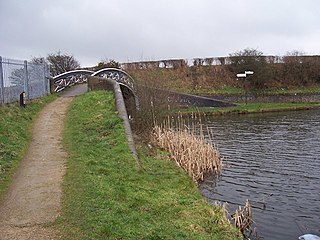
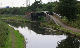
Ogley Junction, on the Staffordshire county border near Brownhills, West Midlands, England, is a historic canal junction on the Wyrley and Essington Canal where the Anglesey Branch left the main line.

<span class="mw-page-title-main">Catshill Junction</span>

Catshill Junction is a canal junction at the northern limit of the Daw End Branch Canal where it meets the Wyrley and Essington Canal main line, near Brownhills, in West Midlands, England.

<span class="mw-page-title-main">Pelsall Junction</span> Canal junction in England

Pelsall Junction is a canal junction at the southern limit of the Cannock Extension Canal where it meets the Wyrley and Essington Canal main line, near Pelsall, West Midlands, England.

<span class="mw-page-title-main">Birchills Junction</span> Canal junction in the uk

Birchills Junction is the canal junction at the northern limit of what is now called the Walsall Canal where it meets the Wyrley and Essington Canal main line, near Walsall, West Midlands, England. It opened in 1798, but lasted for little more than a year, until it was re-opened in 1841 when a connecting link was built to the Birmingham Canal Navigations' southern route to Walsall.

<span class="mw-page-title-main">Spon Lane Junction</span>

Spon Lane Junction is the original junction of the Wednesbury Canal and the Birmingham Canal, near Oldbury in the West Midlands, England.

<span class="mw-page-title-main">Birmingham and Liverpool Junction Canal</span>

The Birmingham and Liverpool Junction Canal was a canal in England which ran from Nantwich, where it joined the Chester Canal, to Autherley, where it joined the Staffordshire and Worcestershire Canal. Forming part of a major link between Liverpool and the industrial heartlands of the Midlands, the canal was opened in 1835, and merged with the Ellesmere and Chester Canal Company in 1845, which became the Shropshire Union Railways and Canal Company in the following year.

References

  1. Hadfield 1985 , p. 99
  2. Hadfield 1985 , pp. 260–261
  3. 1 2 Hadfield 1985 , pp. 328–329
  4. Hadfield 1985 , p. 279
  5. Hadfield 1985 , p. 280
  6. 1 2 Shill 2002 , p. 42
  7. Nicholson 2006 , pp. 43–44
  8. Atkins 2009 , p. 3
  9. Cumberlidge 2009 , pp. 74–76
  10. Ordnance Survey, 1:2500 maps, 1902, 1918, 1962

52°40′42″N2°00′48″W / 52.6784°N 2.0132°W / 52.6784; -2.0132