Tipton Green and Toll End Canals

Last updated

Contents

Tipton Green and Toll End Canals
BSicon POINTERg@fq.svg
BSicon uSTR.svg
Tame Valley Canal
BSicon uSTRq.svg
BSicon uSTRq.svg
BSicon uFABZqlr.svg
BSicon uFABZq+lr.svg
BSicon ugFABZq+lr.svg
Tame Valley Jn, Ocker Hill Tunnel Jn, Toll End Jn, Arrow Blue Left 001.svg Walsall Canal Arrow Blue Right 001.svg
BSicon POINTERg@fq.svg
BSicon gSTR.svg
Toll End Branch
BSicon gFGATEd.svg
BSicon gFGATEd.svg
Toll End Locks (7)
BSicon gSTR.svg
BSicon exBUILDING.svg
BSicon gSTR.svg
Horseley Ironworks (original)
BSicon POINTERg@fq.svg
BSicon gSTR.svg
BSicon gFGATEd.svg
Tipton Green Branch
BSicon gFABZgl+l.svg
BSicon ugFGATEl.svg
BSicon gSTRr.svg
BSicon gFGATEd.svg
BSicon gFGATEd.svg
BSicon ugddSTRl.svg
BSicon gmKRZu.svg
Stour Valley Line
BSicon gFGATEd.svg
Arrow Blue Left 001.svg Wolverhampton (BCN Main Line) – BCN New Main Line (Island Line) Arrow Blue Right 001.svg
BSicon uFABZq+lr.svg
BSicon uLOCKSl.svg
BSicon ugFABZqlr+lr.svg
BSicon uSTRq.svg
BSicon uSTRq.svg
Factory Jn, Tipton Factory Locks (3), Watery Lane Jn
BSicon uSTR.svg
BSicon gFGATEd.svg
BSicon uSTR.svg
BSicon gFGATEd.svg
Tipton Green Locks (3)
BSicon uSTR.svg
BSicon gFGATEd.svg
BSicon uSTRl.svg
BSicon uSTRq.svg
BSicon ugFABZqlr.svg
BSicon uFABZq+lr.svg
BSicon uSTRq.svg
Tipton Green Jn, Tipton Jn. BCN Old Main Line to Birmingham Arrow Blue Right 001.svg
BSicon uSTR.svg
to Dudley Tunnel
A derelict lock on the Tipton Green Canal, closed in the 1960s, now a public walkway. Tipton Green derelict lock.jpg
A derelict lock on the Tipton Green Canal, closed in the 1960s, now a public walkway.
Watery Lane Junction. Caggy's Boatyard (started in the 1960s), within the start of the derelict Toll End Communication Canal (left and centre bridges). Watery Lane Junction.jpg
Watery Lane Junction. Caggy's Boatyard (started in the 1960s), within the start of the derelict Toll End Communication Canal (left and centre bridges).
The canals of the BCN around Tipton. Tipton Green and Toll End Branches running across the centre BCN canal map Wednesbury Oak.svg
The canals of the BCN around Tipton. Tipton Green and Toll End Branches running across the centre

The Tipton Green Branch and Toll End Branch (or Toll End Communication Canal) were narrow canals comprising part of the Birmingham Canal Navigations near Tipton (formerly in Staffordshire), West Midlands, England. These canals no longer exist.

History

The Tipton Green Branch was completed around 1805 with 3 locks and a length of quarter of a mile. [1]

The Toll End Branch was authorised by Act of Parliament in 1783 (along with the Birmingham and Fazeley Canal, Broadwaters Canal, and several other branches) to provide access to a proposed new coal mine. Work was started from the Broadwaters Canal (now part of the Walsall Canal) but halted in 1784 for eight years, being completed as a closed branch with two locks in 1801. [2] In 1806 it was decided to extend this branch to the Tipton Green Branch with further locks, and in January 1809 the Toll End Communication Canal was completed [2] making the length 1 3/8 miles. [1]

In 1829 Thomas Telford's BCN New Main Line (Island Line)cut across the Tipton Green Canal, forming Watery Lane Junction, and creating a de facto Tipton Green Locks Branch of three locks and a Toll End Locks Branch of seven locks. From the later 20th Century Caggy's Boatyard occupied the basin at Watery Lane Junction. [3]

The Horseley Ironworks operated their first foundry from a site between the two branches where many iron bridges, including the Engine Arm Aqueduct (1825), two roving bridges at Smethwick Junction (1828) and Galton Bridge, were cast.

Having suffered from a century or more of declining traffic due to the advent of trains and then motor vehicles, the Tipton Green Branch became disused in 1960, and the Toll End Branch in 1966, after some of the locks along the canal became immovable. [4] The locks and canals were infilled in 1968. The Tipton Green locks were lined with houses which were built around the mid 19th century, but these were demolished around the time of the canal's closure.

The brick base of one lock on the Tipton Green canal, however, remains in existence, forming part of a public footpath that followed the course of the canal and was opened in about 1975.

One part of the Toll End canal has since been occupied by the car park of a factory in Toll End Road. There is also an "open" drain along the route of the canal at the back of Tipton Cemetery, but apart from this the canal has been almost obliterated. Almost all of the bridges are still in existence, apart from the bridge on Bridge Road which carried the road under the Toll End Canal. This bridge was replaced with a flat road several years after the canal was filled in.

Route

Map all coordinates using: OpenStreetMap  
Download coordinates as: KML

See also

Related Research Articles

<span class="mw-page-title-main">Birmingham and Fazeley Canal</span> Canal in the United Kingdom

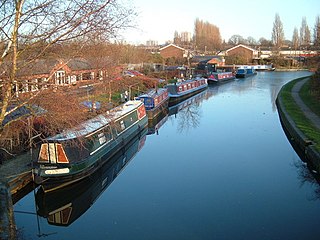
The Birmingham and Fazeley Canal is a canal of the Birmingham Canal Navigations in the West Midlands of England. Its purpose was to provide a link between the Coventry Canal and Birmingham and thereby connect Birmingham to London via the Oxford Canal.

<span class="mw-page-title-main">Wyrley and Essington Canal</span> Narrow canal in the Midlands, England

The Wyrley and Essington Canal, known locally as "the Curly Wyrley", is a canal in the English Midlands. As built it ran from Wolverhampton to Huddlesford Junction near Lichfield, with a number of branches: some parts are currently derelict. Pending planned restoration to Huddlesford, the navigable mainline now terminates at Ogley Junction near Brownhills. In 2008 it was designated a Local Nature Reserve.

<span class="mw-page-title-main">Birmingham Canal Navigations</span>

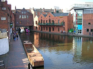
Birmingham Canal Navigations (BCN) is a network of canals connecting Birmingham, Wolverhampton, and the eastern part of the Black Country. The BCN is connected to the rest of the English canal system at several junctions. It was owned and operated by the Birmingham Canal Navigations Company from 1767 to 1948.

<span class="mw-page-title-main">Tame Valley Canal</span>

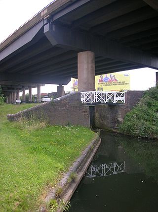
The Tame Valley Canal is a relatively late (1844) canal in the West Midlands of England. It forms part of the Birmingham Canal Navigations. It takes its name from the roughly-parallel River Tame.

<span class="mw-page-title-main">Toll End</span> Residential area in Tipton, England

Toll End is a residential area of Tipton in the West Midlands of England. It was developed during the 19th century during the Industrial Revolution which saw previously rural Tipton developed as one of the most prolific manufacturing and mining towns in the country. It is situated on the former A461 road which connects Dudley to Walsall.

<span class="mw-page-title-main">Aston Junction</span>

Aston Junction is the name of the canal junction where the Digbeth Branch Canal terminates and meets the Birmingham and Fazeley Canal near to Aston, Birmingham, England.

<span class="mw-page-title-main">Cannock Extension Canal</span>

The current Cannock Extension Canal is a 1.8-mile (2.9 km) canal in England. It runs from Pelsall Junction on the Wyrley and Essington Canal, north to Norton Canes Docks and forms part of the Birmingham Canal Navigations. Historically, it ran to Hednesford, and served a number of collieries, which provided the main traffic. It opened in 1863, and the northern section closed in 1963, as a result of mining subsidence.

The BCN Main Line, or Birmingham Canal Navigations Main Line is the evolving route of the Birmingham Canal between Birmingham and Wolverhampton in England.

<span class="mw-page-title-main">Water levels of the Birmingham Canal Navigations</span>

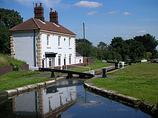
The Birmingham Canal Navigations (BCN), a network of narrow canals in the industrial midlands of England, is built on various water levels. The three longest are the Wolverhampton, Birmingham, and Walsall levels. Locks allow boats to move from one level to another.

<span class="mw-page-title-main">Smethwick Junction (canal)</span>

Smethwick Junction is the name of the canal junctions where the Birmingham Canal Navigations Main Line Canal from Birmingham splits into the BCN Old Main Line and the BCN New Main Line near to Smethwick, West Midlands, England.

<span class="mw-page-title-main">Walsall Canal</span>

The Walsall Canal is a narrow canal, seven miles (11 km) long, forming part of the Birmingham Canal Navigations, and passing around the western side of Walsall, West Midlands, England.

<span class="mw-page-title-main">Rushall Junction</span> Canal junction

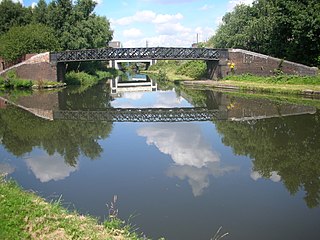
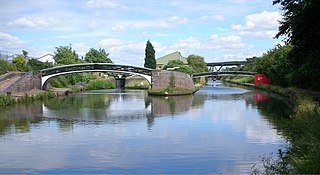
Rushall Junction is the southern limit of the Rushall Canal where it meets the Tame Valley Canal in the West Midlands, England. It opened in 1847, when the Rushall Canal was built to create connections between the Birmingham Canal Navigations system and the Wyrley and Essington Canal, following the amalgamation of the two companies in 1840.

<span class="mw-page-title-main">Tame Valley Junction</span> Canal junction

Tame Valley Junction, also known as Doe Bank Junction, is a canal junction at the western limit of the Tame Valley Canal where it meets the Walsall Canal, south of Walsall, in the West Midlands, England.

<span class="mw-page-title-main">Birchills Junction</span> Canal junction in the uk

Birchills Junction is the canal junction at the northern limit of what is now called the Walsall Canal where it meets the Wyrley and Essington Canal main line, near Walsall, West Midlands, England. It opened in 1798, but lasted for little more than a year, until it was re-opened in 1841 when a connecting link was built to the Birmingham Canal Navigations' southern route to Walsall.

<span class="mw-page-title-main">Wednesbury Old Canal</span>

Wednesbury Old Canal is part of the Birmingham Canal Navigations (BCN) in West Midlands (county), England. It opened in 1769, and although parts of it were abandoned in 1955 and 1960, the section between Pudding Green Junction and Ryder's Green Junction is navigable, as it provides a link to the Walsall Canal. A short stub beyond Ryder's Green Junction is connected to the network but difficult to navigate.

<span class="mw-page-title-main">Spon Lane Junction</span>

Spon Lane Junction is the original junction of the Wednesbury Canal and the Birmingham Canal, near Oldbury in the West Midlands, England.

<span class="mw-page-title-main">Bromford Junction</span>

Bromford Junction is a canal junction at the foot of the Spon Lane Locks where the Spon Lane Locks Branch meets the BCN New Main Line near Oldbury in the West Midlands, England.

<span class="mw-page-title-main">Ridgacre Branch</span> UK canal

The Ridgacre Branch is a canal branch of the Wednesbury Old Canal, part of the Birmingham Canal Navigations, in the West Midlands, England. It opened in 1828, to serve collieries and iron works, and was disused by the 1960s. Except for its branches and a small section at the eastern end, which have been filled in, most of it is still in water, but it is not navigable as a low-level bridge carrying the Black Country New Road spans the entrance.

<span class="mw-page-title-main">Wednesbury Oak Loop</span>

The Wednesbury Oak Loop, sometimes known as the Bradley Arm, is a canal in the West Midlands, England. It is part of the Birmingham Canal Navigations (BCN), and was originally part of James Brindley's main line, but became a loop when Thomas Telford's improvements of the 1830s bypassed it by the construction of the Coseley Tunnel. The south-eastern end of the loop was closed and in parts built over, following the designation of the entire loop as "abandoned" in 1954, including the section which was filled in at the beginning of the 1960s to make way for the Glebefields Estate in Tipton.

<span class="mw-page-title-main">Bradley Branch</span>

The Bradley Branch or Bradley Locks Branch was a short canal of the Birmingham Canal Navigations in the West Midlands, England. Completed in 1849, it included nine locks, and had a number of basins which enabled it to service local collieries and industrial sites. The locks were unusual, as they had a single gate at both ends, rather than double gates at the bottom end. The route closed in the 1950s, and the top seven locks were covered over and landscaped.

References

  1. 1 2 Hadfield, Charles (1969). The Canals of the West Midlands (Second ed.). David & Charles. ISBN   0-7153-4660-1.
  2. 1 2 Broadbridge, S. R. (1974). The Birmingham Canal Navigations, Vol. 1 1768 - 1846. David & Charles. ISBN   0-7509-2077-7.
  3. Pearson, Michael (1989). Canal Companion - Birmingham Canal Navigations. J. M. Pearson & Associates. ISBN   0-907864-49-X.
  4. Historical Map of the Birmingham Canals, Richard Dean, M. & M. Baldwin, 1989, ISBN   0-947712-08-9

52°31′55″N2°03′23″W / 52.5319°N 2.0565°W / 52.5319; -2.0565