Ona, West Virginia

Last updated

Ona, West Virginia
USA West Virginia location map.svg
Red pog.svg
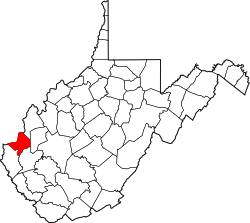
Ona
Location within the state of West Virginia
Usa edcp location map.svg
Red pog.svg
Ona
Ona (the United States)
Coordinates: 38°25′29″N82°12′48″W / 38.42472°N 82.21333°W / 38.42472; -82.21333
Country United States
State West Virginia
County Cabell
Area
  Total28.060 sq mi (72.675 km2)
  Land27.840 sq mi (72.106 km2)
  Water0.220 sq mi (0.569 km2)
Population
  Total4,512
  Density160/sq mi (62/km2)
Time zone UTC-5 (Eastern (EST))
  Summer (DST) UTC-4 (EDT)
ZIP codes
25545
GNIS feature ID1544405
[1] [2]

Ona is a small unincorporated community along US 60 (the old Midland Trail) in Cabell County, West Virginia, United States. It is situated roughly halfway between the towns of Barboursville to the west and Milton to the east. It has a population of 4,512 and spans over a radius of 28.06 square miles. [3]

Contents

Ona is a part of the Huntington-Ashland, WV-KY-OH, Metropolitan Statistical Area (MSA). As of the 2010 census, the MSA had a population of 287,702. New definitions from February 28, 2013 placed the population at 363,000. [4]

Landmarks and culture

John F. Kennedy at a campaign stop in Ona for his successful bid for President of the United States in 1960. JFKInOnaWestVirginia1960.gif
John F. Kennedy at a campaign stop in Ona for his successful bid for President of the United States in 1960.

Ona is home to three notable places. The first is Cabell Midland High School, which is the consolidated regional secondary school for students living in the eastern half of Cabell County. This is a rather large high school of modern construction, with extensive athletic facilities. The student population varies from 1,500 to 2,000 students.

A second landmark is the Ona Speedway. This is a prime location for local stock-car racing competitions. The track has had its share of financial difficulties and has been closed several times in prior years. It has, however, been operating continuously since 2006. The last time NASCAR held a Cup level race on a Tuesday was August 11, 1970, when Richard Petty won the West Virginia 300 in Ona. [5]

The third landmark is the Ona Airpark. This airstrip consists of a 3154x40 foot runway (heading 064/244 magnetic) with an associated taxiway, 48 hangars, FBO and a parking lot. Flying lessons are offered Hangar 9 Aviation on site. The airport's IATA Airport Code is 12V, and its CTAF frequency is 122.8 MHz. Landing and departure control are conducted from Charleston's Yeager Airport. Ona Airpark does not have its own control tower.

Ona is also home to the Ona Little League Athletic Complex, part of the Ona Milton Little League, which sits just across the Mud River from the Ona Airpark. Spectators from around the tri-state come every spring and fall to enjoy a relaxing afternoon or evening of baseball or softball.

Related Research Articles

<span class="mw-page-title-main">Cabell County, West Virginia</span> County in West Virginia, United States

Cabell County is located in the U.S. state of West Virginia. As of the 2020 census, the population was 94,350, making it West Virginia's fourth most-populous county. Its county seat is Huntington. The county was organized in 1809 and named for William H. Cabell, the Governor of Virginia from 1805 to 1808. Cabell County is part of the Huntington–Ashland, WV–KY–OH Metropolitan Statistical Area.

<span class="mw-page-title-main">Manassas, Virginia</span> Independent city in Virginia, United States

Manassas, formerly Manassas Junction, is an independent city in the Commonwealth of Virginia, United States. The population was 42,772 at the 2020 Census. It is the county seat of Prince William County, although the two are separate jurisdictions. Manassas borders the independent city of Manassas Park, Virginia. The Bureau of Economic Analysis includes both Manassas and Manassas Park with Prince William County for statistical purposes.

<span class="mw-page-title-main">Mooresville, North Carolina</span> Town in North Carolina, United States

Mooresville is a town located in the southwestern section of Iredell County, North Carolina, United States, and is a part of the fast-growing Charlotte metropolitan area. The population was 50,193 at the 2020 census, making it the most populous municipality in Iredell County. It is located approximately 25 miles (40 km) north of Charlotte.

<span class="mw-page-title-main">Barboursville, West Virginia</span> Village in West Virginia, United States

Barboursville is a village in Cabell County, West Virginia, United States. The population was 4,456 at the 2020 census. It is part of the Huntington–Ashland metropolitan area.

<span class="mw-page-title-main">Milton, West Virginia</span> Town in West Virginia, United States

Milton is a town in Cabell County, West Virginia, United States. The population was 2,831 at the 2020 census. It is part of the Huntington–Ashland metropolitan area.

<span class="mw-page-title-main">Midland, Texas</span> City in Texas

Midland is a city in the U.S. state of Texas and the seat of Midland County with small portions extending into Martin County. The population was 132,524 as of the 2020 census. Located in the Permian Basin in West Texas, Midland is a major center for American oil and natural gas production.

<span class="mw-page-title-main">Indianapolis metropolitan area</span> Metropolitan area in Indiana, United States

The Indianapolis metropolitan area is an 11-county metropolitan area in the U.S. state of Indiana. Its principal cities are Indianapolis, Carmel, Greenwood, and Anderson. Other primary cities with populations of more than 50,000 include Fishers, Noblesville, and Westfield. Located in Central Indiana, it is the largest metropolitan area entirely within Indiana and the seventh largest in the American Midwest.

<span class="mw-page-title-main">Greater Richmond Region</span> Metropolitan statistical area in the United States

The Greater Richmond Region, the Richmond metropolitan area or Central Virginia, is a region and metropolitan area in the U.S. state of Virginia, centered on Richmond. The U.S. Office of Management and Budget (OMB) defines the area as the Richmond, VA Metropolitan Statistical Area, a Metropolitan Statistical Area (MSA) used by the U.S. Census Bureau and other entities. The OMB defines the area as comprising 17 county-level jurisdictions, including the independent cities of Richmond, Petersburg, Hopewell, and Colonial Heights. As of 2020, it had a population of 1,314,434, making it the 44th largest MSA in the country.

<span class="mw-page-title-main">Southwest Florida</span> Region in Florida

Southwest Florida is the region along the southwest Gulf coast of the U.S. state of Florida. The area is known for its beaches, subtropical landscape, and winter resort economy.

<span class="mw-page-title-main">Greater Pittsburgh</span> Region in the U.S. State of Pennsylvania

Greater Pittsburgh is the metropolitan area surrounding the city of Pittsburgh in Western Pennsylvania, United States. The region includes Allegheny County, Pittsburgh's urban core county and economic hub, and seven adjacent Pennsylvania counties: Armstrong, Beaver, Butler, Fayette, Lawrence, Washington, and Westmoreland in Western Pennsylvania, which constitutes the Pittsburgh, PA Metropolitan Statistical Area MSA as defined by the U.S. Census Bureau.

<span class="mw-page-title-main">West Virginia Secondary School Activities Commission</span>

The West Virginia Secondary School Activities Commission is the main governing body of high school sports, cheerleading, and marching bands in West Virginia, United States. For sports other than basketball schools are divided into three classes by total enrollment in grades 9-12: A, AA, and AAA, with schools re-classed every four years. Football, baseball, cheerleading, golf, softball, track, and volleyball are broken into these three classes. Soccer, Cross country, tennis, and wrestling are broken into two classes. Swimming is one class only. For basketball, schools are divided into four classes. Schools have the option of playing "up" one class in a particular sport.

<span class="mw-page-title-main">Mahoning Valley</span> Metropolitan area in Ohio, United States

The Youngstown–Warren, OH Metropolitan Statistical Area, typically known as the Mahoning Valley, is a metropolitan area in Northeast Ohio with Youngstown, Ohio, at its center. According to the U.S. Census Bureau, the metropolitan statistical area (MSA) includes Mahoning and Trumbull counties. As of the 2020 census, the region had a population of 430,591, making it the 125th-largest metro area in the country.

Cabell Midland High School is located in Ona, West Virginia. Cabell Midland is a four-year high school which serves grades 9 through 12. The school's name is derived from two sources; "Cabell" for the county in which it is located, and "Midland" for the famous Midland Trail which once extended from Norfolk, Virginia to Los Angeles, California.

The Huntington–Ashland metropolitan area is a metropolitan area in the Appalachian Plateau region of the United States. Referred to locally as the "Tri-State area," and colloquially as "Kyova", the region spans seven counties in the three states of Kentucky, Ohio, and West Virginia. With a population of 361,580, the Tri-State area is nestled along the banks of the Ohio River. The region offers a diverse range of outdoor activities.

<span class="mw-page-title-main">Lesage, West Virginia</span> Census-designated place in West Virginia, United States

Lesage is a census-designated place (CDP) on Ohio River Road in Cabell County, West Virginia, United States. As of the 2010 census, its population was 1,358. It is the nearest community to the Clover site, a National Historic Landmark.

Sod is an unincorporated community in northeastern Lincoln County, West Virginia, United States. It lies along West Virginia Route 214 east of the town of Hamlin, the county seat of Lincoln County. Sod's elevation is 781 feet (238 m). It has a post office with the ZIP code 25564.

<span class="mw-page-title-main">Salt Rock, West Virginia</span> Census-designated place in West Virginia, United States

Salt Rock is a census-designated place (CDP) in southern Cabell County, West Virginia, United States. As of the 2010 census, its population was 388. It lies along West Virginia Route 10 southeast of the city of Huntington, the county seat of Cabell County. Its elevation is 581 feet (177 m). Although Salt Rock is unincorporated, it has a post office, with the ZIP code of 25559. The community most likely was so named on account of there being a small-scale local salt manufacturing industry.

Jefferson County Airpark , is a full-service general aviation public airport near Steubenville, Ohio, U.S., part of the Pittsburgh Combined Statistical Area that serves small and mid-sized private, corporate and commercial traffic. The airport serves transients traveling to and from Eastern Ohio, the Northern Panhandle of West Virginia, and Western Pennsylvania (Pittsburgh). The airport founded in January 1948 by R. G. and Pauline Pier as Pier Airport.

Lindrith is an unincorporated community in Rio Arriba County, New Mexico, United States. Lindrith is located in southern Rio Arriba County along New Mexico State Road 595. Lindrith has a post office with ZIP code 87029. The Lindrith Airpark, a public-use airport, is located in Lindrith. Lindrith has a charter elementary school, the Lindrith Area Heritage School.

Martin Ward is a former Marshall University running back.

References

  1. United States Postal Service (2012). "USPS - Look Up a ZIP Code" . Retrieved February 15, 2012.
  2. "Geographic Names Information System". United States Geological Survey . Retrieved January 31, 2008.
  3. "Zip Code 25545". unitedstateszipcodes.org. Retrieved January 15, 2024.
  4. "Population statistics" (PDF). Archived from the original (PDF) on March 19, 2013.
  5. Fielden, Greg (2005). NASCAR Chronicle . Lincolnwood, Illinois: Publications International. pp.  496. ISBN   1-4127-1200-9.