Pallikkal Bazar

Last updated

Pallikkal Bazar
Pallikkal
Census town
CUIET.jpg
India Kerala location map.svg
Red pog.svg
Pallikkal Bazar
Location in Kerala, India
India location map.svg
Red pog.svg
Pallikkal Bazar
Pallikkal Bazar (India)
Coordinates: 11°9′0″N75°54′0″E / 11.15000°N 75.90000°E / 11.15000; 75.90000
CountryFlag of India.svg  India
State Kerala
District Malappuram
Government
  TypeLocal
  BodyGrama Panchayat
Population
 (2001)
  Total38,166
Languages
  Official Malayalam, English
Time zone UTC+5:30 (IST)
PIN
673634, 673636
Vehicle registration KL-84
Nearest city Kozhikode
Nearest major towns Kondotty, Feroke
Lok Sabha constituency Malappuram
Kerala Legislative Assembly Constituency Vallikkunnu
Taluk Kondotty
Telephone Code0483, 0494
The children of Pallikkal Bazar Football ground on College Road, Pallikkal Bazar.jpg
The children of Pallikkal Bazar
Sunni Madhrassah in Pallikkal Bazar T-junction Hidayathu Sibyan Madrassa, Pallikkal Bazar.jpg
Sunni Madhrassah in Pallikkal Bazar T-junction

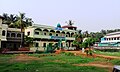
Pallikkal (Pallikkal Bazar) is a T-shaped town, village and gram panchayat in Kondotty Taluk, Malappuram district in the state of Kerala, India. [1]

Contents

Calicut International Airport at Karipur is near Pallikkal.

Pallikkal Bazar is with in 5 km from the University of Calicut and from Kondotty.

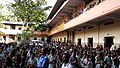
Kerala’s first Akshaya center was started in Pallikal gram panchayat. AMLP School Pallikkal is in Pallikkal Bazar.

Proposed Karipur-Kondotty Municipality

The proposed Karipur-Kondotty Municipality comprises [2]

Total Area: 122.99 km2

Total Population (1991 Census): 152,839

Demographics

As of 2001 India census, Pallikkal had a population of 38166 with 18945 males and 19221 females.[ clarification needed ] [1]

Landmarks

Suburbs and villages

Transportation

Calicut International Airport is located in Pallikkal panchayath and is situated around 7 kms away from Pallikkal Bazar town.

The nearest railway stations are at Feroke, Parappanangadi and Vallikunnu. The nearest major railway station at Kozhikode is 20 kms away.

Pallikkal Bazar town and surrounding areas are also well connected by road and local bus transportation systems. National Highway 66 and National Highway 966 are 2.5 kms and 3 kms away respectively from Pallikkal Bazar. The town itself is located on Kakkanchery-Kottapuram road which is a major throughfare and also a major link between NH-66 and NH-966.

Related Research Articles

<span class="mw-page-title-main">Nilambur</span> Place in Kerala, India

Nilambur is a major town, a municipality and a Taluk in the Malappuram district of the Indian state of Kerala. It is located close to the Nilgiris range of the Western Ghats on the banks of the Chaliyar River. This place is also known as 'Teak Town' because of the abundance of Nilambur teaks in this area; Which is a variety of a large, deciduous tree that occurs in mixed hardwood forests. Unlike many Municipalities of India; Nilambur is covered with large amounts of vegetation making it close to nature and hence make it very scenic and inspiring.

<span class="mw-page-title-main">Karipur</span> Airport Village in Kerala, India

Karipur is a locality in the Kondotty taluk of the Malappuram district of Kerala, India, 25 km (16 mi) from the city of Malappuram. It is best known as the site of Calicut International Airport, serving travellers of mainly the South Malabar region. Other than that, it is a small hamlet that comes under the jurisdiction of Kondotty Municipality and Pallikkal gram panchayat. Karipur forms a portion of the Malappuram metropolitan area as of 2011 Census.

<span class="mw-page-title-main">Kondotty</span> Municipality in Kerala, India

Kondotty is a developing town, municipality, and aerotropolis in the Malappuram district state of Kerala, India which is located near Calicut International Airport, 24 km from Malappuram. It is the headquarters of Kondotty Taluk, which was declared as the seventh taluk in Malappuram district by chief minister Oommen Chandy on 23 December 2013.

<span class="mw-page-title-main">Idimuzhikkal</span> Census town in Kerala, India

Idimuzhikkal or Chelembra is a town in Malappuram district, Kerala, India. Chelembra is the Panchayath and Idimuzhikal is the capital of this Panchayath. Chelembra grama panchayat in the district.

<span class="mw-page-title-main">Tenhipalam</span> Census town in Kerala, India

Thenhipalam is a census town and a panchayat in Tirurangadi taluk in Malappuram district of Kerala, India, with a population of 27,273 as per 2001 census, consisting of 13,293 males and 13,980 females. Tenhipalam forms a portion of the Malappuram metropolitan area as of 2011 Census. University of Calicut, the first university in the Malabar region, is located north-west part of the Panchayat. 'Chelari' is the main commercial place in Tenhipalam panchayat while 'Panambra' is considered the headquarters of the panchayat. The small town between Chelari and the university is called Kohinoor.

<span class="mw-page-title-main">Alakode, Kannur district</span> Town in Kerala, India

Alakode is an emerging town and a panchayath in Kannur district in the Indian state of Kerala. It is located 46 km (29 mi) north of district headquarters Kannur. Alakode is located on Taliparamba-Manakadavu-Coorg Road. Alakode was one of the major centers of Malabar Migration.

<span class="mw-page-title-main">Payyavoor</span> Town in Kerala, India

Payyavoor is a small town in Kannur district in the Indian state of Kerala. It's the headquarters of Payyavoor Grama Panchayat.

<span class="mw-page-title-main">Kalluvathukkal</span> Village in Kerala, India

Kalluvathukkal is a village in the Kollam district of the Indian state of Kerala. NH 47 passes through the village. Kalluvathukkal panchayat has its own school for classes from the 5th to 10th standard. A small stadium is located next to the school. The nearest town is Chathannoor. The place is infamous for the Kalluvathukkal hooch tragedy, which took place on 21 October 2000 and killed 31 people.

<span class="mw-page-title-main">Athavanad</span> Village in Kerala, India

Athavanad is a village and Gram Panchayath in the Tirur Taluk, in the Malappuram District of the state of Kerala, India. The town lies on the National Highway 17, between Puthanathani and Valanchery. Puthanathani is the main town of the Athavanad village and the village office is located in Athavanad Para & Kurumbathoor. Nearby towns include Valanchery, Tavanur, Tirunavaya, Kuttippuram, Irimbiliyam, and Edayur.

<span class="mw-page-title-main">Nediyiruppu</span> Suburb of Kondotty in Malappuram, Kerala, India

Nediyiruppu was the capital of the Zamorin's kingdom in colonial Kerala. At the time, it was known as Nediyiruppu Swaroopam. It is a region of the Kondotty municipality in Malappuram district, Kerala, India. It is situated 24 kilometres (15 mi) from Malappuram, the district headquarters.

Ozhur is a village in the Malappuram district of the state of Kerala, India. The village was a part of the Kingdom of Tanur (Vettattnad) in medieval times.

<span class="mw-page-title-main">Pulikkal</span> Village in Kerala, India

Pulikkal or Cherukavu is a village in Malappuram district in the state of Kerala, India.

<span class="mw-page-title-main">Purathur</span> Village in Kerala, India

Purathur is a sandy coastal village and a Grama Panchayat in Tirur Taluk, Malappuram district in the state of Kerala, India. Bharathappuzha river and Tirur River merges together in Purathur and join with the Arabian Sea at Padinjarekara Azhimukham, which is also the southernmost tip of Purathur Gram panchayat. Opposite to Padinjarekara Azhimukham is Ponnani port. The village is located at the southernmost tip of Tirur Taluk and is bordered by historically important Ponnani port in Ponnani Municipality of Ponnani taluk to south.

<span class="mw-page-title-main">Vazhayur</span> Census town in Kerala, India

Vazhayur is a census town in Malappuram in the state of Kerala, India. The Vazhayur Census Town has population of 36,909 of which 18,163 are males while 18,746 are females as per report released by Census India 2011. The 2018 Malayalam film Sudani from Nigeria was shot in Vazhayur. The town forms a portion of the Malappuram metropolitan area.

<span class="mw-page-title-main">Areekode</span> Town in Kerala, India

Areekode is a town on the banks of the Chaliyar River in Areekode Grama Panchayat in Malappuram district, India. It was part of the Malabar district in British India.

<span class="mw-page-title-main">Cherukavu</span> Census town in Kerala, India

Cherukavu is a census town in Malappuram district in the state of Kerala, India.

<span class="mw-page-title-main">Perinthalmanna</span> Town in Kerala, India

Perinthalmanna is a major city and municipality in Malappuram district, Kerala, India. It serves as the administrative centre for the Perinthalmanna taluk, as well as a revenue division, a community development block, and a police sub-division bearing the same name. It was formerly the headquarters of Valluvanad Taluk, which was one of the two Taluks in the Malappuram Revenue Division of the erstwhile Malabar District during the British Raj. The town is located 23 kilometres (14 mi) southwest to the city of Malappuram at the centre of the Kozhikode–Malappuram–Perinthalmanna–Palakkad National Highway 966.

<span class="mw-page-title-main">Kondotty taluk</span> Taluk in Kerala, India

Kondotty Taluk, otherwise called Western Eranad Taluk, comes under Tirur revenue division in Malappuram district of Kerala, India. Its headquarters is the town of Kondotty. Kondotty Taluk contains Kondotty municipality and a few Gram panchayats.

<span class="mw-page-title-main">Athavanad Grama Panchayat</span> Grama Panchayat in Kerala, India

Athavanad is a village and Grama Panchayat in the Malappuram district, the Indian state of Kerala.

<span class="mw-page-title-main">Valenchery</span> Place in Kerala, India

Valenchery is a small town in Morayur Gram panchayat in Malappuram in Malappuram district of state of Kerala. Valenchery is divided into four Areas, they are Village Road, Colony Road, Madrasa Road and Hilltop Area.Four Wards from Morayur Panchayath partly belongs to Valenchery. Nearest places are Valluvambram Junction, Mongam, Morayur, Arimbra and Pookkottur. Nearest tourist spot is Mini Ooty.

References

  1. 1 2 "Census of India : Villages with population 5000 & above". Registrar General & Census Commissioner, India. Retrieved 10 December 2008.
  2. "Talks on Karipur airport development today". The Hindu . 3 November 2004. Retrieved 3 May 2015.[ dead link ]