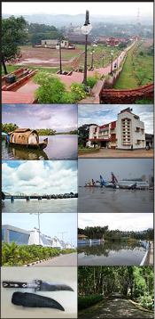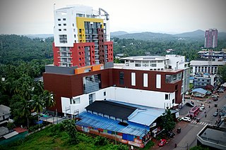
Malappuram, is one of the 14 districts in the Indian state of Kerala, with a coastline of 70 km (43 mi). It is the most populous district of Kerala, which is home to around 13% of the total population of the state. The district was formed on 16 June 1969, spanning an area of about 3,554 km2 (1,372 sq mi). It is the third-largest district of Kerala by area, as well as the largest district in the state, bounded by Western Ghats and Arabian Sea to either side. The district is divided into seven Taluks: Eranad, Kondotty, Nilambur, Perinthalmanna, Ponnani, Tirur, and Tirurangadi.

Tanur is a coastal town, a municipality, and a block located in Tirur Taluk, Malappuram district, Kerala, India. It is located on the Malabar Coast, 9 kilometres (5.6 mi) north of Tirur and 9 kilometres south of Parappanangadi. It is the 17th-most populated municipality in the state, the fourth-most populated municipality in the district, and the second-most densely populated municipality in Malappuram district, having about 3,568 residents per square kilometre as of the year 2011.

Kuttippuram is a town and a block headquarters, which is situated in the Tirur Taluk, Malappuram district of Kerala state, India. The town is located 34 kilometres south-west of Palakkad. The Bharathappuzha river flows through Kuttippuram. According to the last Census of India conducted in 2011,

Valanchery is a major municipal town in Malappuram district, Kerala, India. It is one of the four municipalities in Tirur Taluk, besides Tirur, Kottakkal, and Tanur. It is situated about 40 kilometres (25 mi) southeast to Karipur International Airport and 25 kilometres (16 mi) southwards to the district headquarters, and forms a part of Malappuram metropolitan area. It is also one of the major commercial towns under the Malappuram urban agglomeration. Valanchery, which was a part of the erstwhile princely state of the Valluvanad in the early medieval period, had been under the direct control of the Zamorin of Calicut following the Tirunavaya war of 14th century CE. During British Raj, Valanchery was included in the Ponnani Taluk of erstwhile Malabar District. Vattapara accident zone is an accident zone near Valanchery. Valanchery is situated on National Highway 66. There is a huge demand to bifurcate the Tirur and Perinthalmanna taluks and form a new taluk, headquarters at Valanchery. It is under consideration by the state government.
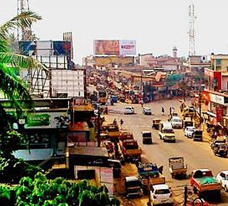
Athavanad is a village and Gram Panchayath in the Tirur Taluk, in the Malappuram District of the state of Kerala, India. The town lies on the National Highway 17, between Puthanathani and Valanchery. Puthanathani is the main town of the Athavanad village and the village office is located in Athavanad Para & Kurumbathoor. Nearby towns include Valanchery, Tavanur, Tirunavaya, Kuttippuram, Irimbiliyam, and Edayur. Athavanad is also famous for historical Azhvanchery Mana which built about 400 years ago.
Kalpakanchery is a revenue village and a Gram Panchayat in Tirur Taluk, Malappuram district, Kerala, India. The village is located 21 kilometres (13 mi) south-west to the city of Malappuram.

Marakkara is a grama panchayath in Kuttippuram Block Panchayat, Tirur Taluk, Malappuram district in the state of Kerala, India.
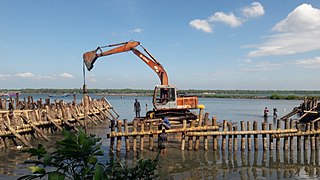
Purathur is a beautiful sandy coastal village and a Grama Panchayat in Tirur Taluk, Malappuram district in the state of Kerala, India. Bharathappuzha river and Tirur River merges together in Purathur and join with the Arabian Sea at Padinjarekara Azhimukham, which is also the southernmost tip of Purathur Gram panchayat. Opposite to Padinjarekara Azhimukham is Ponnani port. The village is located at the southernmost tip of Tirur Taluk and is bordered by historically important Ponnani port in Ponnani Municipality of Ponnani taluk to south.

Parudur is a village and gram panchayat in Pattambi taluk, Palakkad district in the state of Kerala, India. Parudur was originally a part of Kuttippuram Block Panchayat in Tirur Taluk of erstwhile Kozhikode district, before the formation of Malappuram district. After the formation of Malappuram district, Tirur Taluk became a part of Malappuram and Parudur village was transferred to Ottapalam Taluk. Today it forms part of Pattambi taluk.

Kumaranellur is a small Village/hamlet in Pattambi Taluk in Palakkad District of Kerala, India. It comes under Kappur Grama Panchayath. It is located 75 km westwards from District headquarters Palakkad, 48 km southwards from the neighbouring district headquarters Malappuram, 27 km from Tirur, 22 km from Valanchery, 20 km from Pattambi, 20 km from Kunnamkulam, 15 km from Ponnani, 14 km from Kuttippuram, 8 km from Thrithala, and 5 km from Edappal town. This Place is in the border of the Palakkad District and Malappuram District. Malappuram District Kuttippuram is North towards this place and Edappal is westward from this place. Kumaranellur basically depends upon neighbouring Ponnani, Edappal, and Kuttippuram in Malappuram district for education and healthcare purposes. It is a part of Thrithala and Ponnani.

Ponnani Taluk comes under Tirur revenue division in Malappuram district of Kerala, India home town of kundan Rubi. Its headquarters is the town of Ponnani. Ponnani Taluk contains Ponnani Municipality and nine gram panchayats. Most of the administrative offices are located in the Mini-Civil Station at Ponnani.

Tirur Taluk comes under Tirur revenue division in Malappuram district of Kerala, India. Its headquarters is the town of Tirur. Tirur Taluk contains four municipalities - Tanur, Tirur, Kottakkal, and Valanchery. Most of the administrative offices are located in the Mini-Civil Stations at Tirur, Kuttippuram, and Tanur. Most of the villages in present-day Tirur Taluk were parts of the medieval Kingdom of Tanur (Vettathunadu). The port of Tanur was an important port town in the southwestern coast of India during medieval period.
Perinthalmanna is a major city and municipality in Malappuram district, Kerala, India. It serves as the headquarters of the Perinthalmanna Taluk, and a block and a Revenue Division by the same name. It was formerly the headquarters of Valluvanad Taluk, which was one of the two Taluks in the Malappuram Revenue Division of the erstwhile Malabar District during the British Raj. The town is located 23 kilometres (14 mi) southwest to the city of Malappuram at the centre of the Kozhikode–Malappuram–Perinthalmanna–Palakkad National Highway 966.
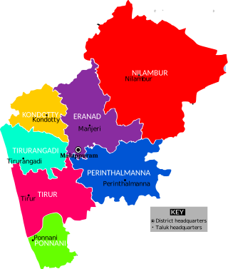
The Malappuram district has four types of administrative hierarchies:

Athavanad is a village and Grama Panchayat in the Malappuram district, the Indian state of Kerala.

Kottakkal State assembly constituency is one of the 140 state legislative assembly constituencies in Kerala state in southern India. It is also one of the 7 state legislative assembly constituencies included in the Ponnani Lok Sabha constituency. As of the 2021 assembly elections, the current MLA is K. K Abid Hussain Thangal of IUML.

Mangalam is a coastal village in Tirur Taluk, Malappuram district, Kerala, India. The village is located 9 kilometres (5.6 mi) south-west to the town of Tirur, 16 kilometres (9.9 mi) away from Ponnani, and 17 kilometres (11 mi) south to Tanur. Kootayi, known for its picturesque beach, is an important town in the jurisdiction of Mangalam Grama Panchayat.

Kuttippuram State assembly constituency was one of the 140 state legislative assembly constituencies in Kerala state in southern India, before the 2008 delimitation of constituencies. It was one of the 7 state legislative assembly constituencies included in the Ponnani Lok Sabha constituency until the 2008 delimitation. The last election to the constituency was conducted in 2006, and the MLA was K. T. Jaleel of LDF.

Kurukkoli Moideen is a politician from Kerala, India. He represents Tirur assembly constituency in 15th Kerala State Legislative Assembly. He belongs to Indian Union Muslim League.


