This article needs additional citations for verification .(February 2023) |
Balussery | |
---|---|
Town | |
Coordinates: 11°27′N75°50′E / 11.45°N 75.83°E | |
Country | India |
State | Kerala |
District | Kozhikode |
Government | |
• Type | Grama Panchayat |
• Panchayat President | Roopalekha Kombilad (LDF) |
• M.L.A | Adv K. M. Sachin Dev (LDF) |
• M.P | M. K. Raghavan (UDF) |
Area | |
• Total | 22.44 km2 (8.66 sq mi) |
Elevation | 42 m (138 ft) |
Population (2011) | |
• Total | 27,363 |
• Density | 1,200/km2 (3,200/sq mi) |
Languages | |
Time zone | UTC+5:30 (IST) |
PIN | 673612 |
Telephone code | 91 496 |
Vehicle registration | KL-76 Nanminda RTO |
Website | http://balussery.com |
Balussery is a town located about 25 km northeast of Kozhikode city and lies on State Highway 34. It is one of the 12 block Panchayats in Kozhikode district. Balussery is the Northeast side entry of Calicut city.
Balussery is located at a distance of about 25 km away from Kozhikode, the district headquarters, and is well connected by road to the nearby towns. There are three main roads that span out from the Balussery city centre. Kozhikode is accessible by two routes, via the Balussery-Kozhikode main Road and the Balussery-Ulliyeri-Kozhikode Road. The major city Thamarassery is about 15 km away and can be reached by the Koyilandi Edavanna Road, and Koyilandi Town is about 16 km away. The town has a bus stand-cum-shopping complex and acts as the origin of the bus services to all the main surrounding places.
Balussery block has an area of 278.54 km2. There are eight Grama Panchayats in the block: Atholi, Balussery, Koorachundu, Kottur, Naduvannur, Panangad, Ulliyeri and Unnikulam. The total population is 212,592: 105,962 males and 106,631 females.
Government offices are situated in the heart of the town. Kerala State Electricity Board has a 33 kV substation (at Manjappalam), a division office/subdivision, and a section office here. There is also an employment exchange at Balussery Mukku, a Kerala Police Circle office, a PWD office, a Sub Registrar Office, an Educational Department Office, six co-operative banks, State Bank of India, Canara Bank, Syndicate Bank, Punjab National Bank, Federal Bank, Bank of Baroda, HDFC bank and ICICI bank.
Regular bus services operate throughout Kozhikode, Thamarassery, Koyilandy, Koorachundu, Koottalida and Perambra. Mini-buses connect the hinterland to Balussery Town. KSRTC operates services to the hilly regions of Balussery, like Mankayam, Koorachundu, Kakkayam, Kallanode, Cheekkilode, and Vayalada.
There are three government higher secondary schools located in Balussery. Govt. Vocational Higher Secondary School and GHSS girls high school are near the town, and Kokkallur HSS is 3 km away from town. There are also primary and upper primary schools, like Balussery GLP school, A.L.P School Thuruthyad.
There is a central government institute named Adarsha Sanskrit Vidya Peetham, located in Vaikundam. It is one of several Sanskrit Colleges in Kerala.
PT Usha School of Athletics is at Vattoli Bazaar. Saraswathy Vidya Mandir is situated 2 km away from Balussery.
Balussery has always been the most influential constituency of the LDF. Most of the workers are from CPIM. The Left Front has been winning with a huge lead in successive assembly and panchayat elections. As of the 2021 assembly elections, the current MLA is Adv K.M Sachindev of CPI(M) and he got a massive lead of 20372 votes The opposite candidates are Dharmajan Bolgaty for UDF and Libin Balussery for NDA. Other political parties in the area are Muslim League, Indian National Congress, BJP, NCP, Janata Dal, welfareparty, and SDPI.
Vayalada Hill Station
Vayalada Hill Station is a hill station in Balussery in the proximity of Vettakkorumakan Temple.And its popularly knowns as Gavi of Malabar.
Thonikadavu Tourist Place
Thonikadavu is a tourist place located in Balussery,its called as Switzerland of Kerala.
Pokkunnu Hills View Point
Pokkunnu Hills View Point, Commonly known as Pokkunnu Mala, is a hill station in Balussery
Balussery-Kotta and Manjapuzha River
Balussery is home to the Central Fort of Kurumbranad Rajas, the Balussery Kota . It is flanked by a temple dedicated to Vettakkorumakan, known as the largest Vettakkorumakan Temple anywhere. It is 2 km from the bus stand. The Manjapuzha River flows by the side of the temple. There are several small temples nearby, such as Kunnatheru Maha Ganapathy Temple, Ponnaram Theru Maha Ganapathy Temple, Chamundeshwari Temple, Vaikuntam Vishnu Temple, Chinthramangalam SreeKrishna Temple, Ellath Mookambika Temple, and Narasimha Kshetram Nirmaloor. Thekkedathu Nagathan Kavu are also here.
Kinaloor Estate (Cochin Malabar Estates)
Kinaloor Estate (Cochin Malabar Estates) is a valley with a mountain on one side and a rubber plantation on the other. There is a plane in the middle of the plantation and the mountain, a proposed site for the KSIDC (SEZ) industrial area.
The Usha sports school is located at Kinaloor estate, Vattoli Bazaar. The school is located here at Kinaloor estate, Vattoli Bazaar, around 5 km from Balussery.
Kakkayam Dam Site
Kakkayam power station and dam is the sole dam in this region. The powerhouse is around 19 km from Balussery, and the dam is around 35 m
Balussery connects to other parts of India through Koyilandy. The national highway no.66 passes through Koyilandy, and the northern stretch connects to Mangalore, Goa, and Mumbai.
Kappad, or Kappakadavu locally, is a beach and village near Koyilandy, in the district Kozhikode, Kerala, India.
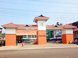
Vatakara,, also spelled Vadakara, French: Bargaret, is a Municipality in the state of Kerala, India. Vatakara is located between Kannur and Kozhikode. The municipality of Vatakara covers an area of 23.33 km2 (9.01 sq mi) and is bordered by Mahé to the north and Payyoli to the south. It is the headquarters of Vatakara taluk, which consists of 22 panchayats. During the reign of the Kolathiris and Zamorins, Vatakara was known as Kadathanadu. During the British Raj, it was part of the North Malabar region of Malabar District in the state of Madras. The historic Lokanarkavu temple, made famous by the Vadakkan Pattukal, is situated in Vatakara. A new tardigrade species collected from Vadakara coast has been named after Kerala State; Stygarctus keralensis.
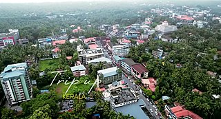
Kozhikode, or Calicut district, is one of the 14 districts in the Indian state of Kerala, along its Southwestern Malabar Coast. The city of Kozhikode, also known as Calicut, is the district headquarters. The district is 67.15% urbanised.Kozhikode city is the fashion capital of Kerala.
Koyilandy is a municipality and a taluk in Kozhikode district, Kerala on the Malabar Coast. The historical town is located right in the middle of the coast of Kozhikode district, between Kozhikode (Calicut) and Kannur, on National Highway 66.
Vattoli Bazaar is a small town situated 2 km east of Balusseri in the Koyilandy -Thamarassery state highway. The location is in Kozhikode district of Kerala state in India.
Kottur is a grama panchayat and a community development block in the Kozhikode district of Kerala, India.
Arikkulam is a village in Kozhikode district in the state of Kerala, India. It's a grampanchayat situated in kozhikode district. Veliyannur challi is situated in arikkulam. Oravinkal temple js a famous temple which is situated in arikkulam.
Chengottukavu is a village in Kozhikode district in the state of Kerala, India.
Moodadi is a village in Koyilandy thaluk of Kozhikode district in the state of Kerala, India.
Naduvannur is a Census town in Kozhikode district in the state of Kerala, India and a part of Kozhikode Urban Agglomeration. The name Naduvannur denotes that it was the centre of the territory of Kurumbranad. 'Nadu' means centre and ur(oor) means place.
Nochad is a village in Kozhikode district in the state of Kerala, India.
Ulliyeri is a village in Kozhikode district in the state of Kerala, India. Ulliyeri is a town between Koyilandy and Balussery and also between Kuttiyadi and Kozhikode.
Thamarassery, formerly known as Thazhmalachery, is one of the taluks and a major hill town in the Kozhikode district of Kerala, India, 30 km north-east of Kozhikode (Calicut) city and 29 km east of Koyilandy. It lies on the Calicut - Wayanad - Mysore route.
Koduvally is a major municipal town in Kozhikode district in the Indian state of Kerala. It is located on the Calicut-Mysuru National Highway 766 and is about 21 km northeast of Kozhikode (Calicut) city. koduvally is known as the city of gold for its gold trade legacy since 18s and 19s. Koduvally is one of the 140 assembly constituencies in Kerala and One of the 12 block panchayats in kozhikode.The nearest local bodies are Kizhakkoth, Madavoor, kunnamangalam, Omassery, Mukkam, and Thamarassery. Koduvally also gives its name to the Koduvally River which flows west into the sea.
Mukkam is a major municipality town in Kozhikode, state of Kerala, India. Mukkam is one of the major regional suburb of the Kozhikode district. Mukkam is located about 27 km east of Calicut city on the bank of river Iruvanjippuzha, one of the major tributaries of river Chaliyar .Mukkam is also well knows for its secularistic features. The urban region of Mukkam is spread across Mukkam Municipality and the North Karassery region of Karassery Grama Panchayath. The town begins from North Karassery junction region and runs till Agasthianmuzhi Junction region.
Omassery is a town in Kozhikode district, Kerala, India and it is a junction between Thiruvambady, Thamarassery, Mukkam, Koduvally, Kodenchery and Kattangal. Omassery is located 29 kilometers southeast of Kozhikode in the eastern part of Kerala; better known as Malabar. Omassery is a fast developing place and is well connected to the other parts of the state. Besides that, it is known as the gateway to the hill ranges of Western Ghats in Malabar.
State Highway 34 is a State Highway in Kerala, India that starts in Koyilandy and ends in Edavanna. The highway is 44.0 km long.
Panangad Grama panchayat is one among the 75 grama panchayat in Kozhikode district. It is near Balussery and coming under Balussery block.
Kozhikode district has an extensive network of road, rail and air travel services. Kozhikode city is the epicenter of the district. Vatakara and Thamarassery are other transport hubs.
Kakkayam is a dam site located at Koorachundu in Kozhikode, Kerala. Kakkayam is on the outskirts of the Western Ghats, and Malabar Wildlife Sanctuary, a 7,421-hectare (18,340-acre) abode of wild animals including elephants and bisons. Kakkayam has an abundant wildlife population and is also a trekking and rock climbing destination.