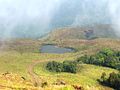
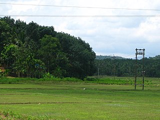
Wayanad is a district in the north-east of the Indian state of Kerala, with its administrative headquarters at the municipality of Kalpetta. It is the only plateau in Kerala. The Wayanad Plateau forms a continuation of the Mysore Plateau, the southern portion of the Deccan Plateau. It is set high in the Western Ghats with altitudes ranging from 700 to 2,100 meters. Vellari Mala, a 2,240 m (7,349 ft) high peak situated on the trijunction of Wayanad, Malappuram, and Kozhikode districts, is the highest point in Wayanad district. The district was formed on 1 November 1980 as the 12th district in Kerala, by carving out areas from Kozhikode and Kannur districts. An area of 885.92 km2 in the district is forested. Wayanad has three municipal towns—Kalpetta, Mananthavady and Sulthan Bathery. There are many indigenous tribes in this area. The Kabini River, a tributary of the Kaveri River, originates at Wayanad. Wayanad district, along with the Chaliyar valley in the neighbouring Nilambur in Malappuram district, is known for natural gold fields, which are also seen in other parts of the Nilgiri Biosphere Reserve. The Chaliyar river, which is the fourth longest river of Kerala, originates on the Wayanad plateau. The historically important Edakkal Caves are located in Wayanad district.

Brahmagiri, is a mountain range in the Western Ghats of south India. It is situated on the border between Kodagu district in Karnataka state in the north and Wayanad district of Kerala state on the south. Brahmagiri Hill, at 1608 m height, near Tirunelli is a scenic tourist attraction. The top of Brahmagiri Hill is well forested and has much wildlife. Talakaveri is located on the northern section of the range, near Bhagamandala in Kodagu district (Coorg), in the South Indian state of Karnataka.

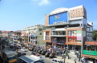
Kalpetta is the largest and first City, Town and municipality in the Wayanad district of the Indian state of Kerala. Kalpetta is the headquarters of Wayanad district, as well as the headquarters of Vythiri taluk. It is a bustling city, town surrounded by dense coffee and tea plantations and mountains. It lies on the Kozhikode-Mysore National Highway NH 766 at an altitude of about 780 m above sea level. Kalpetta is 72 km from Kozhikode and 140 km from Mysore.
Sultan Bathery is a town and municipality in the Wayanad district of Kerala, India, near its borders with Tamil Nadu and Karnataka. Once known as a strategic location in the Malabar region, Sultan Bathery is the headquarters of the Sultan Bathery taluk.

Chembra Peak is a mountain in the state of Kerala, India, with an elevation of 2,100 m (6,890 ft) above sea level. The highest peak in the Wayanad hills and one of the highest peaks in the Western Ghats, adjoining the Nilgiri Hills and Vellarimala, it is located in the Wayanad district of Kerala, near the town of Meppadi and 8 km (5 mi) south of Kalpetta.

Kottathara or Venniyode is a gram panchayat of Wayanad district, Kerala State, India.

Ambalavayal is a village in Wayanad district in the state of Kerala, India. The Wayanad Heritage Museum is located in the village.
Noolpuzha is a village near Sulthan bathery in Wayanad district in the state of Kerala, India.

Padinjarathara is a Major town in Wayanad district in the state of Kerala, India. The Largest Earth Dam in India Banasura Sagar And Other Main Tourist Attractions like Meenmutti Waterfalls, Bappanam mala, Banasura Hill And Kurumbalakotta Are situated in Padinjarathara. India's First Operating Floating Solar Power Plant was Planted in Padinjarathara. It is a Major Junction between Kozhikode and Kalpetta. State Highway 54 passes through Padinjarathara. Its a perfect destination for nature lovers, adventure enthusiasts, and those seeking a peaceful retreat. With attractions like the Banasura Sagar Dam, Banasura Hill, Trekking up, and Meenmutty Waterfalls, along with rich wildlife and cultural experiences, Padinjarathara offers a unique and refreshing getaway in the heart of Kerala. The area around Padinjarathara is rich in biodiversity. The nearby Wayanad Wildlife Sanctuary is home to various species of animals and birds, making it a great spot for wildlife enthusiasts and bird watchers.
Payyampally is a town in Wayanad district in the state of Kerala, India.

Thirunelly is a village in Wayanad district in the state of Kerala, India.
State Highway 29 is a State Highway in Kerala, India that starts at junction of NH 766 at Chundale near Kalpetta and ends in Kerala State Boundary with Tamil Nadu. This highway was originally Kozhikode - Vythiri - State Border and was 97 km long. After the section of the highway from Kozhikode until Chundale became part of NH 212, this highway is now 31.0 km long.

Vythiri is a village located in Wayanad district in the Indian state of Kerala. Along with Mananthavady and Sulthan Bathery, it is one of the three taluks in the district.
Vaduvanchal is a small town in Wayanad district in the state of Kerala, India. It is situated in the Kozhikode-Ooty road. The town is part of the Muppainad Panchayat.

Kunhome is a small village situated in Thondernadu Panchayath, Wayanad district, Kerala, India. It has a diverse cultural heritage. Kunhome is a hub for domestic and international tourists. The village has a distinct identity in tourist destinations of Wayanad due to its historical and cultural heritage.

Kambalakkad is one of the big towns near Kalpetta in the Wayanad district, Kerala, India. It is about 8 kilometres (5.0 mi) away from district headquarters at Kalpetta, and is one of the main towns on the Kalpetta-Manathavady state highway.

Meenangadi is an old town situated on the highway NH 766 between Kalpetta and Sulthan Bathery in Wayanad District, in Kerala, India. This place is one among the Provinces where the existence of Dolmens provide an historical evidence of earlier civilisation. Coffee bean, Black pepper, Ginger, Rice and Areca are the major crops cultivated in this area. Meenangadi is famous for its Fish Market and Cattle Market. The nearest railway station is at Kozhikode at 87 km and airport is Kannur International Airport with 94 km from Meenangadi. Meenangadi is surrounded by, Ambalavayal Panchayat, Kalpetta Taluk towards west, Gudalur Taluk towards East, Mananthavady Taluk towards west. Kalpetta, Sultan Bathery, Kozhikode are the nearby Cities and towns to Meenangadi.
Kerala's first carbon neutrality project launched in Meenangadi in June 2016. Upon achieving the goals of the project, Meenangadi will be the first village in India to go completely carbon neutral. Meenangadi has a population of 33450 According to 2011 Census with two Villages Purakkadi and (Part)Krishnagiri.

Boys Town is a small village near Mananthavady in Wayanad, Kerala, India. The village is 13 km from Mananthavady.

The district capital of Wayanad is Kalpetta town. Kalpetta has very good road connectivity with the rest of Kerala and neighboring South Indian cities. National Highway 766 (India) NH766 connects Kalpetta with Kozhikode and Mysore. State Highways connect Kalpetta with Ooty in Tamil Nadu and Madikeri in Karnataka.
Chettappalam is a small village on Mysore Road between Mananthavady and Kattikkulam in Wayanad district, Kerala state, India.