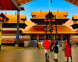
GuruvayurIPA:[guɾuʋɐːjuːr]) is a municipal temple town in Thrissur district, of Kerala State in India. It is a suburban town of Thrissur city, located 27 kilometres (17 mi) from Thrissur towards the north-west. It houses the Guruvayur Shri Krishna Temple. It is located at a distance of 292 km (181 mi) from the state capital Trivandrum towards the north-west, 80 km (50 mi) from Kochi towards the north, 90 km (56 mi) from Calicut towards south.

Neyyattinkara, is a significant municipal town and a prominent center for both industry and commerce, positioned at the southernmost tip of the Thiruvananthapuram metropolitan area in Trivandrum, the capital of Kerala State. It also serves as the administrative headquarters of Neyyattinkara Taluk.Nestled along the banks of the Neyyar River, one of the district's principal rivers, the town derives its name from its location, with 'Neyyatinkara' in Malayalam translating to 'the shore of the river Neyyar.' Neyyattinkara ranks as the second most densely populated municipality in the district, following Varkala. Notably, the Vizhinjam International Seaport Thiruvananthapuram is situated within Neyyattinkara Taluk."

Irinjalakuda is a municipal town in Thrissur district, Kerala, India. It is the headquarters of Irinjalakuda Revenue Division, Thrissur Rural Police and Mukundapuram Taluk. After Thrissur, this town has most number of administrative, law-enforcement, and judicial offices in the district. The place is well known for Koodalmanikyam Temple and the Thachudaya Kaimals, who had princely status until 1971. The earliest recorded history of this temples date back to the ninth century of Common Era (CE).
Mavelikara is a municipality in the Alappuzha district of Kerala, India. It is located 36 km (22.4 mi) south of the district headquarters in Alappuzha and about 95 km (59.0 mi) north of the state capital Thiruvananthapuram. As per the 2011 Indian census, Mavelikkara has a population of 26,421 people, and a population density of 2,088/km2 (5,410/sq mi).
Aluva is an eastern suburb of the city of Kochi in Kerala, India. It is a part of the Kochi metropolitan area and is situated around 15 km (9.3 mi) from the city centre on the banks of Periyar River. A major transportation hub, with easy access to all major forms of transportation, Aluva acts as a corridor which links the highland districts to the rest of Kerala. Cochin International Airport at Nedumbassery is 11.7 km from Aluva. Aluva is accessible through rail, air, metro along with major highways and roadlines. Aluva KSRTC bus station is an important transport hub in Kerala and one of the busiest stations in central part of the state.

Perumbavoor is a municipality in the Ernakulam district of Kerala, India. It is located 18 km (11.2 mi) north of the district collectorate in Thrikkakara and about 187 km (116.2 mi) north of the state capital Thiruvananthapuram. Perumbavoor is part of the Kochi metropolitan area and is located 26 km (16.2 mi) northeast of the Kochi city centre. As per the 2011 Indian census, Perumbavoor has a population of 28,110 people, and a population density of 2,065/km2 (5,350/sq mi).

Kodakara is a town in the Thrissur district of Kerala state in South India. It is located next to the national highway, 20 km (12 mi) south of Thrissur town,3km to the south of Puthukkad town and about 10 km (6.2 mi) north of Chalakudy. Administratively, Kodakara is part of Kodakara Panchayat, Chalakudy taluk and Irinjalakuda revenue division. Kodakara Panchayat is part of Chalakudy assembly constituency and Chalakudy.
Alathur is a town, taluk and gram panchayat in Palakkad District, Kerala, India. It is the administrative headquarters of the Alathur Taluk and is situated about 24 km from the district headquarters Palakkad through National Highway 544.Gayathripuzha River ,one of the tributary of Bharathapuzha, flows through Alathur. Alathur is one among the 29 Parliamentary Constituencies in Kerala. A Mini Civil Station is also located here which provides government related services.
North Paravur, is a municipality in the Ernakulam district of Kerala, India. It is located 20 km (12.4 mi) north of the district collectorate in Thrikkakara and about 201 km (124.9 mi) north of the state capital Thiruvananthapuram. North Paravur is part of the Kochi metropolitan area and is located 19 km (11.8 mi) north of the Kochi city centre. As per the 2011 Indian census, North Paravur has a population of 31,503 people, and a population density of 3,490/km2 (9,000/sq mi).

Thrissur, anglicised as Trichur, is one of the 14 districts in the Indian state of Kerala. It is situated in the central region of the state. Spanning an area of about 3,032 km2 (1,171 sq mi), the district is home to over 9% of Kerala's population.

Piravom is a municipality in the Ernakulam district of Kerala, India. It is located 22 km (13.7 mi) south of the district collectorate in Thrikkakara and about 162 km (100.7 mi) north of the state capital Thiruvananthapuram. As per the 2011 Indian census, Piravom has a population of 27,229 people, and a population density of 927/km2 (2,400/sq mi).

Chowara is a small town near Aluva in the Ernakulam district in the state of Kerala, India.

Wadakkancherry is a major town in Thrissur, Kerala. Up until 1860, this area was part of Chelakkara Taluk. Now, it is the headquarters of Talappilly Taluk. Wadakkanchery obtained municipality status from the government by merging with the Mundathikode panchayath and it is the only town in Thrissur District to be raised as municipality recently. There are two places with similarly pronounced names: Wadakanchery and Vadakkenchery.

Karoor is a village in Kodakara Panchayath in Thrissur district of Kerala, India. Karoor is located 30 km from the city of Thrissur and 12 km from Irinjalakuda Town and 8 km from Chalakudy Town and 8 km from Mala, Kerala Town.
Chalakudy is one of the 20 Lok Sabha (parliamentary) constituencies in the South Indian state of Kerala. It came into existence in 2008, following the delimitation of parliamentary constituencies based on recommendations of the Delimitation Commission of India. The constituency comprises seven assembly segments spread over two districts—Thrissur (3) and Ernakulam (4).

Potta is a tiny village 30 miles north of Kochi, also known as Cochin. It comes under the municipality of Chalakudy in the Thrissur district in the state of Kerala, India. Potta was the temple land under the Irinjalakuda Koodalmanikyam Temple. In the past, the crops needed for the temple were cultivated at Potta. The Pambambot temple is very famous, other two temples in Potta are the Parakottilinkal Bhagavathi Temple and the Mathilthkavu Bhagavathi Temple. Cherupushpam Shrine, a Christian church, is famous. There are educational institutions like Panampilly Memorial Government College, Vyasa Vidyaniketan Central School, Kuriakos Chavara UP School and Dhanya Mission Hospital.
Benny Behanan is an Indian politician from Kerala. He is a member of the Indian National Congress party who serves as Member of Parliament from Chalakudy. He was the MLA of Thrikkakara Legislative Assembly Constituency from 2011 to 2016. He was the General Secretary of the Kerala Pradesh Congress Committee for 17 years. Earlier he had won Piravom in 1982, and unsuccessfully contested the Idukki Parliament Constituency as UDF Candidate to the Lok Sabha in 2004. In 2019 General election, he won the election with a margin of 132274 votes against the LDF candidate Innocent (actor).

Chalakudy State assembly constituency is one of the 140 state legislative assembly constituencies in Kerala. It is also one of the 7 state legislative assembly constituencies included in the Chalakudy Lok Sabha constituency. As of the 2021 assembly elections, the current MLA is T. J. Saneesh Kumar Joseph of Indian National Congress.

Kodungallur State assembly constituency is one of the 140 state legislative assembly constituencies in Kerala. It is also one of the 7 state legislative assembly constituencies included in the Chalakudy Lok Sabha constituency. As of the 2021 assembly elections, the current MLA is V. R. Sunil Kumar of CPI.

Thrissur District has four types of administrative hierarchies:


