Pappinisseri | |
|---|---|
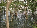
 Mangroves Park | |
 Pappinisseri Location in Kerala, India | |
| Coordinates: 11°57′N75°21′E / 11.95°N 75.35°E | |
| Country | |
| State | Kerala |
| District | Kannur |
| Government | |
| • Type | Panchayati raj (India) |
| • Body | Special Grade Panchayat |
| Area | |
• Total | 15.22 km2 (5.88 sq mi) |
| Elevation | 1 m (3 ft) |
| Population (2011) [1] | |
• Total | 35,134 |
| • Density | 2,300/km2 (6,000/sq mi) |
| Time zone | UTC+5:30 (IST) |
| PIN | 670561, 670565, 670566 |
| Telephone code | 0497278 |
| ISO 3166 code | IN-KL |
| Vehicle registration | KL-13 |
| Sex ratio | 1068 ♂/♀ |
Pappinisseri is a census town in Kannur district in the Indian state of Kerala. [2] Pappinissery have consistently won the Swaraj Trophy for best Grama Panchayat from 2017-2018 to 2021. Pappinisseri Panchayat also bagged the third position in the Swaraj Trophy during 2015-2016. Also, Pappinissery has been declared as the best Grama Panchayat in Kerala by Kerala government. [3] [4] Pappinisseri Panchayat comprises two villages, viz Pappinisseri and Aroli. Pappinisseri better known for visha chikitsa kendram (a treatment for snake bite.)