| Major cities in Kerala ordered by |
|---|
 |
This is a list of cities and towns in the state of Kerala, India with their population. [1] [2]
| Major cities in Kerala ordered by |
|---|
| |
This is a list of cities and towns in the state of Kerala, India with their population. [1] [2]
The urban councils of Kerala date back to the 17th century when the Dutch Malabar established the municipality of Fort Kochi. In 1664, the municipality of Fort Kochi was established by Dutch Malabar, making it the first municipality in the Indian subcontinent, which was dissolved when the Dutch authority got weaker in the 18th century. [3] However, the first modern kind of municipalities were formed in the state in 1866 in Malabar District. In 1866, Fort Kochi municipality was reestablished. Kannur, Thalassery, Kozhikode, Palakkad, and Fort Kochi, which were parts of Malabar District until 1956, were made the first modern municipalities of Kerala on 1 November 1866, according to the Madras Act 10 of 1865 (Amendment of the Improvements in Towns act 1850) [4] [5] [6] [7] of the British Indian Empire. The Thiruvananthapuram Mmnicipality came into existence in 1920. After two decades, during the reign of Sree Chithira Thirunal, Thiruvananthapuram Municipality was converted into a corporation on 30 October 1940, making it the oldest municipal corporation of Kerala. [8] The first municipal corporation formed after the independence of India as well as the second-oldest municipal corporation of the state is Kozhikode Municipal Corporation, established in 1962. [9]
| Rank | City/town | Population (2011) | Area(km2) | Density (/km2) | District |
|---|---|---|---|---|---|
| Municipal corporations | |||||
| 1 | Thiruvananthapuram | 968,990 | 218.86 | 4,427 | Thiruvananthapuram |
| 2 | Kozhikode | 609,224 | 118.58 | 5,138 | Kozhikode |
| 3 | Kochi | 602,046 | 94.88 | 6,345 | Ernakulam |
| 4 | Kollam | 388,288 | 72.19 | 5,379 | Kollam |
| 5 | Thrissur | 315,957 | 101.42 | 3,115 | Thrissur |
| 6 | Kannur | 232,486 | 78.35 | 2,967 | Kannur |
| Municipalities | |||||
| 7 | Alappuzha | 174,164 | 46.20 | 3,770 | Alappuzha |
| 8 | Kottayam | 172,812 | 77.8 | 1,758 | Kottayam |
| 9 | Palakkad | 131,019 | 26.60 | 4,926 | Palakkad |
| 10 | Manjeri | 97,102 | 53.06 | 1,830 | Malappuram |
| 11 | Thalassery | 92,558 | 23.96 | 3,863 | Kannur |
| 12 | Thrippunithura | 92,522 | 29.17 | 3,172 | Ernakulam |
| 13 | Ponnani | 90,491 | 24.82 | 3,646 | Malappuram |
| 14 | Vatakara | 75,295 | 21.32 | 3,532 | Kozhikode |
| 15 | Kanhangad | 73,536 | 39.54 | 1,860 | Kasaragod |
| 16 | Payyanur | 72,111 | 54.63 | 1,320 | Kannur |
| 17 | Koyilandy | 71,873 | 29.05 | 2,474 | Kozhikode |
| 18 | Parappanangadi | 71,239 | 22.25 | 3,202 | Malappuram |
| 19 | Kalamassery | 71,038 | 27.00 | 2,631 | Ernakulam |
| 20 | Kodungallur | 70,868 | 29.24 | 2,424 | Thrissur |
| 21 | Neyyattinkara | 70,840 | 28.78 | 2,461 | Thiruvananthapuram |
| 22 | Tanur | 69,534 | 19.49 | 3,568 | Malappuram |
| 23 | Kayamkulam | 68,634 | 21.79 | 3,150 | Alappuzha |
| 24 | Malappuram | 68,127 | 33.61 | 2,027 | Malappuram |
| 25 | Guruvayur | 67,006 | 29.66 | 2,259 | Thrissur |
| 26 | Thrikkakkara | 65,984 | 28.10 | 2,348 | Ernakulam |
| 27 | Wadakkancherry | 61,341 | 51.56 | 1,190 | Thrissur |
| 28 | Nedumangad | 60,161 | 32.53 | 1,849 | Thiruvananthapuram |
| 29 | Kondotty | 59,256 | 30.93 | 1,916 | Malappuram |
| 30 | Tirurangadi | 56,632 | 17.73 | 3,194 | Malappuram |
| 31 | Tirur | 56,058 | 16.55 | 3,387 | Malappuram |
| 32 | Panoor | 55,216 | 28.53 | 1,935 | Kannur |
| 33 | Kasaragod | 54,172 | 16.69 | 3,246 | Kasaragod |
| 34 | Feroke | 54,074 | 15.54 | 3,480 | Kozhikode |
| 35 | Kunnamkulam | 54,071 | 34.18 | 1,582 | Thrissur |
| 36 | Ottappalam | 53,792 | 32.68 | 1,646 | Palakkad |
| 37 | Thiruvalla | 52,883 | 27.15 | 1,948 | Pathanamthitta |
| 38 | Thodupuzha | 52,025 | 35.43 | 1,468 | Idukki |
| 39 | Perinthalmanna | 49,723 | 34.41 | 1,445 | Malappuram |
| 40 | Chalakudy | 49,525 | 25.23 | 1,963 | Thrissur |
| 41 | Payyoli | 49,470 | 22.34 | 2,214 | Kozhikode |
| 42 | Koduvally | 48,687 | 23.85 | 2,041 | Kozhikode |
| 43 | Mananthavady | 47,974 | 80.10 | 599 | Wayanad |
| 44 | Changanassery | 47,685 | 13.50 | 3,532 | Kottayam |
| 45 | Mattanur | 47,078 | 54.32 | 867 | Kannur |
| 46 | Punalur | 46,659 | 34.45 | 1,354 | Kollam |
| 47 | Nilambur | 46,366 | 30.79 | 1,506 | Malappuram |
| 48 | Cherthala | 45,827 | 16.19 | 2,831 | Alappuzha |
| 49 | Sultan Bathery | 45,417 | 102.24 | 444 | Wayanad |
| 50 | Maradu | 44,704 | 12.35 | 3,620 | Ernakulam |
| 51 | Kottakkal | 44,382 | 20.45 | 2,170 | Malappuram |
| 52 | Taliparamba | 44,247 | 18.96 | 2,334 | Kannur |
| 53 | Shornur | 43,528 | 32.34 | 1,346 | Palakkad |
| 54 | Pandalam | 42,793 | 28.42 | 1,506 | Pathanamthitta |
| 55 | Kattappana | 42,646 | 52.77 | 808 | Idukki |
| 56 | Cherpulassery | 41,267 | 32.00 | 1,290 | Palakkad |
| 57 | Mukkam | 40,670 | 31.20 | 1,304 | Kozhikode |
| 58 | Iritty | 40,369 | 45.84 | 881 | Kannur |
| 59 | Valanchery | 40,318 | 21.90 | 1,841 | Malappuram |
| 60 | Varkala | 40,048 | 15.42 | 2,597 | Thiruvananthapuram |
| 61 | Nileshwaram | 39,752 | 26.23 | 1,515 | Kasaragod |
| 62 | Chavakkad | 39,095 | 12.41 | 3,150 | Thrissur |
| 63 | Kothamangalam | 38,837 | 40.04 | 970 | Ernakulam |
| 64 | Pathanamthitta | 37,545 | 23.50 | 1,598 | Pathanamthitta |
| 65 | Attingal | 37,382 | 16.87 | 2,216 | Thiruvananthapuram |
| 66 | Paravur | 37,245 | 16.19 | 2,300 | Kollam |
| 67 | Ramanattukara | 35,937 | 11.70 | 3,072 | Kozhikode |
| 68 | Mannarkkad | 34,839 | 33.01 | 1,055 | Palakkad |
| 69 | Erattupetta | 34,814 | 18.29 | 1,903 | Kottayam |
| 70 | Sreekandapuram | 33,489 | 69 | 485 | Kannur |
| 71 | Angamaly | 33,391 | 28.24 | 1,182 | Ernakulam |
| 72 | Chittur-Thathamangalam | 32,298 | 14.71 | 2,196 | Palakkad |
| 73 | Kalpetta | 31,580 | 40.74 | 775 | Wayanad |
| 74 | North Paravur | 31,493 | 9.02 | 3,492 | Ernakulam |
| 75 | Haripad | 30,977 | 19.24 | 1,610 | Alappuzha |
| 76 | Muvattupuzha | 30,397 | 13.18 | 2,306 | Ernakulam |
| 77 | Kottarakara | 29,788 | 17.39 | 1,713 | Kollam |
| 78 | Kuthuparamba | 29,619 | 16.76 | 1,767 | Kannur |
| 79 | Adoor | 29,165 | 20.42 | 1,428 | Pathanamthitta |
| 80 | Irinjalakuda | 28,741 | 11.24 | 2,557 | Thrissur |
| 81 | Pattambi | 28,632 | 15.84 | 1,808 | Palakkad |
| 82 | Anthoor | 28,218 | 24.12 | 1,170 | Kannur |
| 83 | Perumbavoor | 28,105 | 13.61 | 2,065 | Ernakulam |
| 84 | Piravom | 27,229 | 29.36 | 927 | Ernakulam |
| 85 | Ettumanoor | 26,933 | 16 | 1,683 | Kottayam |
| 86 | Mavelikkara | 26,421 | 12.65 | 2,089 | Alappuzha |
| 87 | Karunagappalli | 25,336 | 8.43 | 3,005 | Kollam |
| 88 | Eloor | 25,297 | 11.21 | 2,257 | Ernakulam |
| 89 | Chengannur | 23,466 | 14.60 | 1,607 | Alappuzha |
| 90 | Vaikom | 23,245 | 8.73 | 2,663 | Kottayam |
| 91 | Aluva | 22,428 | 7.14 | 3,141 | Ernakulam |
| 92 | Pala | 22,056 | 16.06 | 1,373 | Kottayam |
| 93 | Koothattukulam | 17,523 | 23.18 | 756 | Ernakulam |

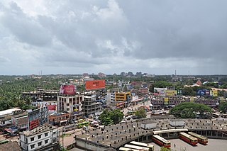
Kozhikode, also known in English as Calicut, is a city along the Malabar Coast in the state of Kerala in India. It has a corporation limit population of 609,224 and a metropolitan population of more than 2 million, making it the second most populous metropolitan area in Kerala and the 19th largest in India. Kozhikode is classified as a Tier 2 city by the Government of India.

Kasaragod is a municipal town and administrative headquarters of Kasaragod district in the state of Kerala, India. Established in 1966, Kasaragod was the first municipal town in the district. It is the northernmost district of Kerala and is also known as Sapta Bhasha Sangama Bhumi.

Palakkad is one of the 14 districts in the Indian state of Kerala. It was carved out of the southeastern region of the former Malabar District on 1 January 1957. It is located at the central region of Kerala and is the second largest district in the state after Idukki. The city of Palakkad is the district headquarters. Palakkad is bordered on the northwest by the Malappuram district, on the southwest by the Thrissur district, on the northeast by Nilgiris district, and on the east by Coimbatore district of Tamil Nadu. The district is nicknamed "The granary of Kerala". Palakkad is the gateway to Kerala due to the presence of the Palakkad Gap, in the Western Ghats. The 2,383 m high Anginda peak, which is situated in the border of Palakkad district, Nilgiris district, and Malappuram district, in Silent Valley National Park, is the highest point of elevation in Palakkad district. Palakkad city is about 347 kilometres (216 mi) northeast of the state capital, Thiruvananthapuram.
Kannur is one of the 14 districts along the west coast in the state of Kerala, India. The city of Kannur is the district headquarters and gives the district its name. The old name, Cannanore, is the anglicized form of the Malayalam name "Kannur". Kannur district is bounded by Kasaragod District to the north, Kozhikode district to the south, Mahé district to the southwest and Wayanad District to the southeast. To the east, the district is bounded by the Western Ghats, which forms the border with the state of Karnataka. The Arabian Sea lies to the west. Paithalmala is the highest point in Kannur District (1,372m). Enclosed within the southern part of the district is the Mahé district of the Union Territory of Puducherry. The district was established in 1957.
Kannur, formerly known in English as Cannanore, is a city and a municipal corporation in the state of Kerala, India. It is the administrative headquarters of the Kannur district and situated 274 kilometres (170 mi) north of the major port city and commercial hub Kochi and 137 kilometres (85 mi) south of the major port city and a commercial hub, Mangalore. During the period of British colonial rule in India, when Kannur was a part of the Malabar District, the city was known as Cannanore. Kannur is the sixth largest urban agglomeration in Kerala. As of 2011 census, Kannur Municipal Corporation, the local body which administers mainland area of city, had a population of 232,486.
Fort Kochi, also known by its former name Fort Cochin is a neighbourhood of Cochin (Kochi) city in Kerala, India. Fort Kochi takes its name from the Fort Manuel of Cochin, the first European fort on Indian soil, controlled by the Portuguese East Indies. This is part of a handful of water-bound islands and islets toward the south-west of the mainland Kochi, and collectively known as Old Cochin or West Cochin. Adjacent to this is the locality of Mattancherry. In 1967, these three municipalities along with a few adjoining areas, were amalgamated to form the Kochi Municipal Corporation.

Malabar District, also known as Malayalam District, was an administrative district on the southwestern Malabar Coast of Bombay Presidency (1792–1800), Madras Presidency (1800–1937), Madras Province (1937–1950) and finally, Madras State (1950–1956) in India. It was the most populous and the third-largest district in the erstwhile Madras State. The historic town of Calicut was the admisnitrative headquarters of this district.

Kozhikode, or Calicut district, is one of the 14 districts in the Indian state of Kerala, along its southwestern Malabar Coast. The city of Kozhikode, also known as Calicut, is the district headquarters. The district is 67.15% urbanised.
Feroke is a Municipality and a part of Kozhikode metropolitan area under Kozhikode Development Authority (K.D.A) in the Kozhikode district of the Indian state of Kerala.

Palakkad, also known as Palghat, historically known as Palakkattussery, is a city and municipality in the Indian state of Kerala. It is the administrative headquarters of Palakkad District. Palakkad is the most densely populated municipality and the fourth-most densely populated city in the state. It was established before Indian independence under British rule and known by the name Palghat. Palakkad is famous for the ancient Palakkad Fort, which is in the heart of the city and was captured and rebuilt by Hyder Ali in 1766 which later fell into the hands of Zamorin in 1784. The city is about 347 kilometres (216 mi) northeast of the state capital, Thiruvananthapuram.
The Kochi Municipal Corporation is the municipal corporation that manages the Indian city of Kochi in the state of Kerala. The Corporation manages 94.88 km2 of Kochi city and has a population of 677,381 within that area. It is the most densely populated city corporation in the state. Kochi Municipal Corporation has been formed with functions to improve the infrastructure of town.
Kochi is a city located in the Ernakulam District in the Indian state of Kerala about 200 km from Trivandrum, the capital of Kerala.

Ramanattukara is a municipality census town in Kozhikode district in the Indian state of Kerala. This town was formerly called Kadungan Chira village. Ramanattukara is located 15 km away from Kozhikode city.

Kasaragod is one of the 14 districts in the southern Indian state of Kerala. Its northern border Thalappady is located just 9 km south to Ullal, which is the southernmost portion of the major port city Mangalore, on the southwestern Malabar coast of India.
Kerala has an urbanisation rate of 47.42%, as compared to the national rate of 31.16%, making it the 2nd most urbanised major state in India. Within Kerala, the rate of urbanisation varied from 3.9% in Wayanad district to 68.1% in Ernakulam district. Municipalities are the urban local governments that deal with civic functions and local development functions in the municipal area. The state of Kerala has 87 municipalities and six municipal corporations. With 13 municipalities, the district of Ernakulam has the most municipalities in the state.

The Kingdom of Kozhikode, also known as Calicut, was the kingdom of the Zamorin of Calicut, in the present-day Indian state of Kerala. Present-day Kozhikode is the second largest city in Kerala, as well as the headquarters of Kozhikode district.
Kozhikode Corporation is the municipal corporation that administers the city of Kozhikode (Calicut), Kerala. Established in 1962, it is in the Kozhikode parliamentary constituency. The first mayor was H. Manjunatha Rao. Its four assembly constituencies are Kozhikode North, Kozhikode South, Beypore and Elathur. The Corporation is headed by a Mayor and council, and manages 118.58 km2 of the city of Kozhikode, with a population of about 609,224 within that area. Kozhikode Municipal Corporation has been formed with functions to improve the infrastructure of town.
The Kannur Municipal Corporation is the municipal corporation that administers the city of Kannur, Kerala. Established in 2015, the Corporation's first mayor was E. P. Latha. Kannur Corporation has two assembly constituencies – Kannur Assembly constituency and Azhikode Assembly constituency – both of which are part of the Kannur parliamentary constituency. The Corporation is headed by a Mayor and council, and manages 78.35 km2 of Kannur city, with a population of about 232,486 within that area. Kannur Municipal Corporation has been formed with functions to improve the infrastructure of town.