This article needs additional citations for verification .(September 2021) |
Triprangode | |
|---|---|
village | |
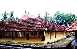 Shiva temple at Thripangodu | |
 Interactive map of Triprangode | |
| Country | |
| State | Kerala |
| District | Malappuram |
| Government | |
| • Body | Triprangode Panchayath |
| Area | |
• Total | 20.67 km2 (7.98 sq mi) |
| Population (2011) | |
• Total | 41,167 |
| • Density | 1,992/km2 (5,158/sq mi) |
| Languages | |
| • Official | Malayalam, English |
| Time zone | UTC+5:30 (IST) |
| PIN | 676108 |
| Telephone code | 0494-256**** |
| Vehicle registration | KL-55 |
| Nearest city | Tirur |
| Literacy | 92.96% |
| Lok Sabha constituency | Ponnani |
| Vidhan Sabha constituency | Thavanur |
| Civic agency | Triprangode Panchayath |
Triprangode is a village in Malappuram district in the state of Kerala, India. [1] As of 2011 [update] India census, Triprangode had a population of 41,167, with 19,174 males and 21,993 females. [2] [1] The village is surrounded by water bodies on three sides.