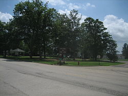
Paw Paw is a village in Lee County in the U.S. state of Illinois. As of the 2020 census, the village was home to 830 people, down from 870 at the 2010 census. It was settled in the mid 19th century and by 1878 the village had a railroad connection. Paw Paw is home to a house which is listed on the U.S. National Register of Historic Places and was the recipient of a 2005 federal grant to construct a water tower.
In 1829, present-day Chicago Road was part of the Frink and Walker stagecoach line from Galena, Illinois to Chicago, though the Potawatomi Indians were the first to use the trail. The tribe didn't turn over the area to the U.S. government until 1833. Frink and Walker also held the mail contract for the area's settlers. The route became popular and garnered a mention in the work of writer Margaret Fuller.[2]
Paw Paw's first permanent resident was David A. Town in 1834, a native of Vermont, Town settled on the southeast side of a 2,000-acre (8km2) grove. The first cabin was built the next spring by Edward Butterfield on the site of Paw Paw. This first house also held the village's first store and would eventually become the first structure in town to burn. During its earliest days, the town was sectioned off into East, West, and South Paw Paw, all of which became known as simply Paw Paw. In 1837, the village got its first postmaster, William Rodgers. Before, the nearest post office was 20 miles away in Somonauk. In 1839, a new road was constructed which allowed mail to be carried from Paw Paw to Princeton. The first stagecoach station (known as a "Tavern") was built along Chicago Road and operated by Isaac Balding. Balding operated the station until the railroad came to town several years later.[3]
Though settlement in present-day Paw Paw began during the 1830s, by 1847 there were probably no more than 50 people in the village. The name Paw Paw was derived from a nearby grove of Pawpaw trees on the edge of a 2,000-acre (8km2) forest. American general Winfield Scott is credited with being the first person of European ancestry to discover the area. The area that Paw Paw is located in was home to more than one stand of Paw Paw trees, thus more than one settlement took the name Paw Paw. To avoid confusion the townspeople renamed the village Wyoming Township. The new name came from the Wyoming Valley in Pennsylvania, where many of Paw Paw's earliest settlers originated.[2] The Wyoming Valley was the scene of a massacre during the American Revolution in which over 300 American settlers were killed by Native Americans allied with the British.[2] Many of Paw Paw's early settlers shared surnames with those who are listed as having been involved in the fighting and massacre.[2]
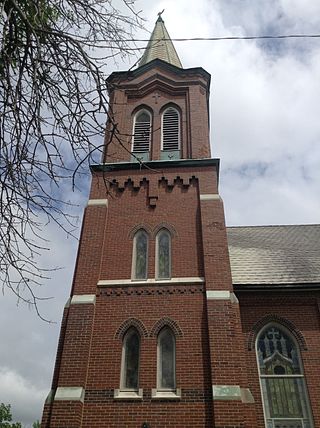
In 1850, Wyoming Township experienced a growth spurt despite being passed over for the coveted railroad link, by this time there were several businesses and a school. By 1878, the village finally got a railroad connection, was home to two newspapers, three churches and was christened, officially, as Paw Paw.[2] The village was officially established in 1882 and is celebrating its 125th anniversary in 2007.[4]
In June 1890 a cyclone destroyed much of Paw Paw, including a schoolhouse. Fourteen people were killed, including 7 in the school.[5]
As of the 2000 United States Census,[9] there were 852 people, 342 households, and 228 families residing in the village. The population density was 1,506.2 inhabitants per square mile (581.5/km2). There were 359 housing units at an average density of 634.7 per square mile (245.1/km2). The racial makeup of the village was 98.71% White, 0.12% Native American, 0.35% Asian, and 0.82% from two or more races. Hispanic or Latino of any race were 1.17% of the population.
There were 342 households, out of which 31.3% had children under the age of 18 living with them, 54.1% were married couples living together, 7.9% had a woman householder with no husband present, and 33.3% were non-families. 30.4% of all households were made up of individuals, and 15.5% had someone living alone who was 65 years of age or older. The average household size was 2.49 and the average family size was 3.09.
In the village, the population was spread out, with 27.7% under the age of 18, 6.9% from 18 to 24, 27.1% from 25 to 44, 23.1% from 45 to 64, and 15.1% who were 65 years of age or older. The median age was 38 years. For every 100 women there were 99.5 men. For every 100 women age 18 and over, there were 97.4 men.
The median income for a household in the village was $37,563, and the median income for a family was $47,500. Men had a median income of $36,833 versus $22,000 for women. The per capita income for the village was $17,461. About 2.9% of families and 5.9% of the population were below the poverty line, including 10.7% of those under age 18 and 5.9% of those age 65 or over.
According to the 2010 census, Paw Paw has a total area of 0.59 square miles (1.53km2), all land.[11] The village is located within close reach of Interstate 39.
Climate
Humid continental climate is a climatic region typified by large seasonal temperature differences, with warm to hot (and often humid) summers and cold (sometimes severely cold) winters. The Köppen Climate Classification subtype for this climate is "Dfa" (Hot Summer Continental Climate).[12]
Climate data for Paw Paw, Illinois (1991–2020 normals, extremes 1935–present)
Public education in Paw Paw is overseen by Unit 271 school district. The district operates Paw Paw Junior High School and Paw Paw Elementary School.[15]Paw Paw Jr/Sr High School opened in 1841 and closed in 2019, with students being sent to Indian Creek High School.[16]
↑ "Station: Paw Paw 2S, IL". U.S. Climate Normals 2020: U.S. Monthly Climate Normals (1991–2020). National Oceanic and Atmospheric Administration. Retrieved July 11, 2021.
Lee County is a county located in the U.S. state of Illinois. According to the 2020 census, it has a population of 34,145. Its county seat is Dixon.
Camden is a town in Kent County, Delaware, United States. It is part of the Dover, Delaware Metropolitan Statistical Area. The population was 3,715 in 2020.
Wyoming is a town in Kent County, Delaware, United States. It was named after the Wyoming Valley in Pennsylvania. It is part of the Dover, Delaware, Metropolitan Statistical Area. The population was 1,680 in 2020.
Frankford is a town in Sussex County, Delaware, United States. The population was 847 at the 2010 census, an increase of 18.6% over the previous decade. It is part of the Salisbury, Maryland-Delaware Metropolitan Statistical Area.
Frankfort is a village in Will County and Cook County in the U.S. state of Illinois. It is a southern suburb of Chicago, and is approximately 28 miles south of the city. As of the 2020 census, the population was 20,296.
Warren is a village in Jo Daviess County, Illinois, United States. The population was 1,323 at the 2020 census, down from 1,428 at the 2010 census.
Old Mill Creek is a village in Lake County, Illinois, United States. Per the 2020 census, the population was 162.
Richmond is a village in McHenry County, Illinois, United States, 46 miles northwest of Chicago. It is a commuter village within the Chicago metropolitan area. The population was 2,089 at the 2020 census.
Wyoming is a city in Stark County, Illinois, United States. The population was 1,429 at the 2010 census, up from 1,424 in 2000. It is the headquarters of the Rock Island Trail State Park. Wyoming is part of the Peoria, Illinois Metropolitan Statistical Area. The former CB&Q Railroad depot in town is the Rock Island Trail State Park's headquarters.
Hebron is a town in Wicomico County, Maryland, United States. The population was 1,084 at the 2010 census. It is included in the Salisbury, Maryland-Delaware Metropolitan Statistical Area. It is the hometown of pro-wrestler Mark Hildreth and politician Scott Taylor.
Dalton is a village in Cheyenne County, Nebraska, United States. The population was 315 at the 2010 census.
Wyoming is a village in Wyoming County, New York, United States. As of the 2010 census, the village has a total population of 434.
Rugby is a city in, and the county seat of, Pierce County, North Dakota, United States. The population was 2,509 at the 2020 census, making it the 19th largest city in North Dakota. Rugby was founded in 1886.
Wyoming is a city in Hamilton County, Ohio; located approximately 12 miles north of downtown Cincinnati and part of the Cincinnati metropolitan area. The population was 8,756 at the 2020 census.
Fairview Township is a township in Luzerne County, Pennsylvania, United States. The population was 4,691 at the 2020 census.
Louisa is a town in Louisa County, Virginia, United States. The population was 1,555 at the 2010 census. It is the county seat of Louisa County.
Paw Paw is a town in Morgan County, West Virginia, United States. The population was 410 at the 2020 census. The town is known for the nearby Paw Paw Tunnel. Paw Paw was incorporated by the Circuit Court of Morgan County on April 8, 1891, and named after pawpaw, a wild fruit that grows in abundance throughout this region. Paw Paw is the westernmost incorporated community in Morgan County, and the Hagerstown-Martinsburg, MD-WV Metropolitan Statistical Area.
Newcastle is a city in and the county seat of Weston County, Wyoming, United States. The population was 3,374 at the 2020 census.
Arcade is a town in Wyoming County, New York, United States. The population was 4220 at the 2020 census.
Warsaw is a village and the county seat of Wyoming County, New York, United States. It lies inside the Town of Warsaw. The village of Warsaw is near the center of the town in a valley. The population was 3,473 at the 2010 census. A branch of Genesee Community College is in Warsaw.
This page is based on this Wikipedia article Text is available under the CC BY-SA 4.0 license; additional terms may apply. Images, videos and audio are available under their respective licenses.