Wyoming Township, Lee County, Illinois

Last updated
Wyoming Township
Township
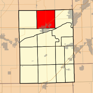
Map highlighting Wyoming Township, Lee County, Illinois.svg
Location in Lee County
Map of Illinois highlighting Lee County.svg
Lee County's location in Illinois
Country United States
State Illinois
County Lee
Established May 14, 1850
Government
  Supervisor Edgar Browder
Area
  Total 36 sq mi (90 km2)
  Land 35.98 sq mi (93.2 km2)
  Water 0.02 sq mi (0.05 km2)  0.06%
Population (2010)
  Estimate (2016) [1] 1,292
  Density 38.2/sq mi (14.7/km2)
Time zone CST (UTC-6)
  Summer (DST) CDT (UTC-5)
FIPS code 17-103-83674

Wyoming Township is located in Lee County, Illinois. As of the 2010 census, its population was 1,376 and it contained 589 housing units. [2] Wyoming Township was originally named Paw Paw Township, but the name was changed on May 14, 1850.

Lee County, Illinois county in Illinois, US

Lee County is a county located in the U.S. state of Illinois. According to the 2010 census, it has a population of 36,031. Its county seat is Dixon.

Illinois State of the United States of America

Illinois is a state in the Midwestern region of the United States. It has the 5th largest Gross Domestic Product by state, is the 6th-most populous U.S. state and 25th-largest state in terms of land area. Illinois is often noted as a microcosm of the entire United States. With Chicago in the northeast, small industrial cities and great agricultural productivity in northern and central Illinois, and natural resources such as coal, timber, and petroleum in the south, Illinois has a diverse economic base, and is a major transportation hub. Chicagoland, Chicago's metropolitan area, contains over 65% of the state's population. The Port of Chicago connects the state to other global ports around the world from the Great Lakes, via the Saint Lawrence Seaway, to the Atlantic Ocean; as well as the Great Lakes to the Mississippi River, via the Illinois Waterway on the Illinois River. The Mississippi River, the Ohio River, and the Wabash River form parts of the boundaries of Illinois. For decades, Chicago's O'Hare International Airport has been ranked as one of the world's busiest airports. Illinois has long had a reputation as a bellwether both in social and cultural terms and, through the 1980s, in politics.

Contents

Geography

According to the 2010 census, the township has a total area of 36 square miles (93 km2), of which 35.98 square miles (93.2 km2) (or 99.94%) is land and 0.02 square miles (0.052 km2) (or 0.06%) is water. [2]

Demographics

Historical population
Census Pop.
Est. 20161,292 [1]
U.S. Decennial Census [3]

Related Research Articles

Paw Paw, Illinois Village in Illinois, United States

Paw Paw is a village in Lee County in the U.S. state of Illinois. As of the 2010 census, the village was home to 870 people, up from 852 at the 2000 census. It was settled in the mid 19th century and by 1878 the village had a railroad connection. Paw Paw is home to a house which is listed on the U.S. National Register of Historic Places and was the recipient of a 2005 federal grant to construct a water tower.

Kaneville Township, Kane County, Illinois Township in Illinois, United States

Kaneville Township is one of sixteen townships in Kane County, Illinois, USA. As of the 2010 census, its population was 1,264 and it contained 508 housing units.

Willow Creek Township, Lee County, Illinois Township in Illinois, United States

Willow Creek Township is located in Lee County, Illinois. As of the 2010 census, its population was 688 and it contained 277 housing units. Willow Creek Township was formed from Wyoming Township in September, 1854.

Channahon Township, Will County, Illinois Township in Illinois, United States

Channahon Township is located in Will County, Illinois. As of the 2010 census, its population was 10,322 and it contained 3,486 housing units.

Jackson Township, Will County, Illinois Township in Illinois, United States

Jackson Township is in Will County, Illinois. As of the 2010 census, its population was 4,100 and it contained 1,610 housing units.

Joliet Township, Will County, Illinois Township in Illinois, United States

Joliet Township is located in Will County, Illinois. As of the 2010 census, its population was 87,398 and it contained 32,617 housing units.

Lockport Township, Will County, Illinois Township in Illinois, United States

Lockport Township is located in Will County, Illinois. As of the 2010 census, its population was 60,010 and it contained 22,016 housing units.

Wesley Township, Will County, Illinois Township in Illinois, United States

Wesley Township is located in Will County, Illinois. As of the 2010 census, its population was 2,241 and it contained 891 housing units. Wesley Township was formed from the south-eastern part of Wilmington Township in 1846. Wesley, Illinois was the setting for a murder in the 1966 mystery fiction book "Deadline" by Thomas B. Dewey

Paw Paw Township, DeKalb County, Illinois Township in Illinois, United States

Paw Paw Township is one of nineteen townships in DeKalb County, Illinois, USA. As of the 2010 census, its population was 334 and it contained 137 housing units.

Naperville Township, DuPage County, Illinois Township in Illinois, United States

Naperville Township is one of nine townships in DuPage County, Illinois, USA. As of the 2010 census, its population was 100,019 and it contained 39,999 housing units.

Brookfield Township, LaSalle County, Illinois Township in Illinois, United States

Brookfield Township is located in LaSalle County, Illinois. As of the 2010 census, its population was 1,060 and it contained 433 housing units.

Fall River Township, LaSalle County, Illinois Township in Illinois, United States

Fall River Township is located in LaSalle County, Illinois. As of the 2010 census, its population was 763 and it contained 339 housing units. Fall River Township was formed from Grand Rapids Township on an unknown date.

Mendota Township, LaSalle County, Illinois Township in Illinois, United States

Mendota Township is located in LaSalle County, Illinois, United States. As of the 2010 census, its population was 7,534 and it contained 3,111 housing units. Mendota Township was formed from Meriden Township in February, 1856.

Ottawa Township, LaSalle County, Illinois Township in Illinois, United States

Ottawa Township is located in LaSalle County, Illinois. As of the 2010 census, its population was 11,766 and it contained 5,601 housing units.

Wallace Township, LaSalle County, Illinois Township in Illinois, United States

Wallace Township is located in LaSalle County, Illinois. As of the 2010 census, its population was 491 and it contained 201 housing units. Wallace Township was formed from Dayton Township on an unknown date.

Chatsworth Township, Livingston County, Illinois Township in Illinois, United States

Chatsworth Township is located in Livingston County, Illinois. As of the 2010 census, its population was 1,366 and it contained 639 housing units.

Newtown Township, Livingston County, Illinois Township in Illinois, United States

Newtown Township is located in Livingston County, Illinois. As of the 2010 census, its population was 733 and it contained 334 housing units.

Marengo Township, McHenry County, Illinois Township in Illinois, United States

Marengo Township is located in McHenry County, Illinois. As of the 2010 census, its population was 7,564 and it contained 3,067 housing units. Marengo is a city located in the township.

Saratoga Township, Grundy County, Illinois Township in Illinois, United States

Saratoga Township is one of seventeen townships in Grundy County, Illinois, USA. As of the 2010 census, its population was 6,122 and it contained 2,541 housing units.

Highland Township, Grundy County, Illinois Township in Illinois, United States

Highland Township is one of seventeen townships in Grundy County, Illinois, USA. As of the 2010 census, its population was 288 and it contained 129 housing units.

References

  1. 1 2 "Population and Housing Unit Estimates" . Retrieved June 9, 2017.
  2. 1 2 "Population, Housing Units, Area, and Density: 2010 - County -- County Subdivision and Place -- 2010 Census Summary File 1". United States Census. Retrieved 2013-05-28.
  3. "Census of Population and Housing". Census.gov. Retrieved June 4, 2016.

Coordinates: 41°40′46″N88°59′28″W / 41.67944°N 88.99111°W / 41.67944; -88.99111

Geographic coordinate system Coordinate system

A geographic coordinate system is a coordinate system that enables every location on Earth to be specified by a set of numbers, letters or symbols. The coordinates are often chosen such that one of the numbers represents a vertical position and two or three of the numbers represent a horizontal position; alternatively, a geographic position may be expressed in a combined three-dimensional Cartesian vector. A common choice of coordinates is latitude, longitude and elevation. To specify a location on a plane requires a map projection.