
Pine Creek Township is located in Ogle County, Illinois, United States. As of the 2010 census, its population was 758 and it contained 320 housing units.

Amboy Township is one of twenty-two townships in Lee County, Illinois, USA. As of the 2010 census, its population was 3,108 and it contained 1,360 housing units.

Brooklyn Township is one of twenty-two townships in Lee County, Illinois, USA. As of the 2010 census, its population was 793 and it contained 358 housing units. In September 1858, Reynolds Township was formed from part of Brooklyn Township.
Lee Center Township is located in Lee County, Illinois. As of the 2010 census, its population was 593 and it contained 269 housing units.
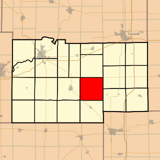
Reynolds Township is located in Lee County, Illinois. As of the 2010 census, its population was 297 and it contained 127 housing units. Reynolds Township formed from Brooklyn Township in September, 1858.

South Dixon Township is located in Lee County, Illinois. As of the 2010 census, its population was 918 and it contained 393 housing units. South Dixon was formed from Dixon Township on February 12, 1867.

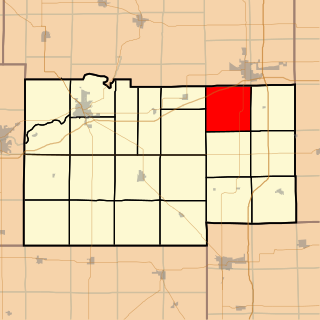
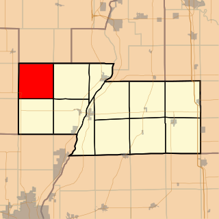
Viola Township is located in Lee County, Illinois. As of the 2010 census, its population was 351 and it contained 132 housing units. Viola Township was originally named Stockton Township and was formed from Brooklyn Township on February 12, 1861. The name was changed to Viola Township in September, 1861.
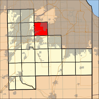
Homer Township is located in Will County, Illinois. As of the 2010 census, its population was 39,059 and it contained 13,418 housing units. In 2001, the village of Homer Glen was incorporated within area that is Homer Township. This region was formerly an unincorporated census-designated place known as Goodings Grove, Illinois.
Lenzburg Township is located in St. Clair County, Illinois. As of the 2010 census, its population was 1,047 and it contained 450 housing units.

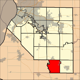
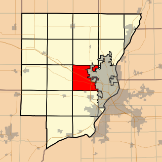
LaSalle Township is located in LaSalle County, Illinois. As of the 2010 census, its population was 13,565 and it contained 6,356 housing units. LaSalle Township was formed from Peru Township on an unknown date.

Mendota Township is located in LaSalle County, Illinois, United States. As of the 2010 census, its population was 7,534 and it contained 3,111 housing units. Mendota Township was formed from Meriden Township in February, 1856.

Peru Township is located in LaSalle County, Illinois. As of the 2010 census, its population was 10,732 and it contained 4,971 housing units. Peru Township was originally named Salisbury Township, but was changed on September 27, 1856.

El Paso Township is located in Woodford County, Illinois. As of the 2010 census, its population was 3,459 and it contained 1,387 housing units. El Paso Township formed from Palestine Township in September, 1861. El Paso is located at 40°44'20" North, 89°0'58" West.
Saratoga Township is located in Marshall County, Illinois. As of the 2010 census, its population was 286 and it contained 135 housing units. Saratoga Township formed from a portion of Whitefield Township sometime before 1860.

Cotton Hill Township is located in Sangamon County, Illinois. As of the 2010 census, its population was 902 and it contained 389 housing units. The township is the home of Hunter Lake, a proposed 3,010-acre (12.2 km2) reservoir.

Hallock Township is located in Peoria County, Illinois, United States. As of the 2010 census, its population was 1,600 and it contained 619 housing units. The current supervisor Kevin Peterson has served in this position since 1994.
Kickapoo Township is located in Peoria County, Illinois. As of the 2010 census, its population was 7,158 and it contained 3,005 housing units. Kickapoo Township changed its name from Orange Township on an unknown date, but the best guess is 1850.

Osceola Township is located in Stark County, Illinois. As of the 2010 census, its population was 1,014 and it contained 428 housing units.

Penn Township is located in Stark County, Illinois. As of the 2010 census, its population was 354 and it contained 136 housing units.

Carbondale Township is one of sixteen townships in Jackson County, Illinois, USA. As of the 2010 census, its population was 29,544 and it contained 14,341 housing units. Southern Illinois University is located in this township.


