Peirce quincuncial projection

Last updated
Peirce quincuncial projection of the world. The red equator is a square whose corners are the only four points on the map at which the projection fails to be conformal. Peirce quincuncial projection SW 20W.JPG
Peirce quincuncial projection of the world. The red equator is a square whose corners are the only four points on the map at which the projection fails to be conformal.
The Peirce quincuncial projection with Tissot's indicatrix of deformation. Peirce Quincuncial with Tissot's Indicatrices of Distortion.svg
The Peirce quincuncial projection with Tissot's indicatrix of deformation.

The Peirce quincuncial projection is the conformal map projection from the sphere to an unfolded square dihedron, developed by Charles Sanders Peirce in 1879. [1] Each octant projects onto an isosceles right triangle, and these are arranged into a square. The name quincuncial refers to this arrangement: the north pole at the center and quarters of the south pole in the corners form a quincunx pattern like the pips on the five face of a traditional die. The projection has the distinctive property that it forms a seamless square tiling of the plane, conformal except at four singular points along the equator.

Contents

Typically the projection is square and oriented such that the north pole lies at the center, but an oblique aspect in a rectangle was proposed by Émile Guyou in 1887, and a transverse aspect was proposed by Oscar Adams in 1925.

The projection has seen use in digital photography for portraying spherical panoramas.

History

The maturation of complex analysis led to general techniques for conformal mapping, where points of a flat surface are handled as numbers on the complex plane. While working at the United States Coast and Geodetic Survey, the American philosopher Charles Sanders Peirce published his projection in 1879, [2] having been inspired by H. A. Schwarz's 1869 conformal transformation of a circle onto a polygon of n sides (known as the Schwarz–Christoffel mapping). In the normal aspect, Peirce's projection presents the Northern Hemisphere in a square; the Southern Hemisphere is split into four isosceles triangles symmetrically surrounding the first one, akin to star-like projections. In effect, the whole map is a square, inspiring Peirce to call his projection quincuncial, after the arrangement of five items in a quincunx.

After Peirce presented his projection, two other cartographers developed similar projections of the hemisphere (or the whole sphere, after a suitable rearrangement) on a square: Guyou in 1887 and Adams in 1925. [3] The three projections are transversal versions of each other (see related projections below).

Formal description

The Peirce quincuncial projection is "formed by transforming the stereographic projection with a pole at infinity, by means of an elliptic function". [4] The Peirce quincuncial is really a projection of the hemisphere, but its tessellation properties (see below) permit its use for the entire sphere. The projection maps the interior of a circle onto the interior of a square by means of the Schwarz–Christoffel mapping, as follows: [5]

where

An elliptic integral of the first kind can be used to solve for w. The comma notation used for sd(u, k) means that is the modulus for the elliptic function ratio, as opposed to the parameter [which would be written sd(u|m)] or the amplitude [which would be written sd(u\α)]. The mapping has a scale factor of 1/2 at the center, like the generating stereographic projection.

Note that:

is the lemniscatic sine function (see Lemniscate elliptic functions).

Properties

A grid on the square dihedron under inverse Peirce quincuncial projection is conformal except at four singularities around the equator. Each grid line is a spherical conic. Peirce projection spherical conics.png
A grid on the square dihedron under inverse Peirce quincuncial projection is conformal except at four singularities around the equator. Each grid line is a spherical conic.

According to Peirce, his projection has the following properties (Peirce, 1879):

Tiled Peirce quincuncial maps

Tessellated version of the Peirce quincuncial map Peirce quincuncial projection SW 20W tiles.JPG
Tessellated version of the Peirce quincuncial map

The projection tessellates the plane; i.e., repeated copies can completely cover (tile) an arbitrary area, each copy's features exactly matching those of its neighbors. (See the example to the right). Furthermore, the four triangles of the second hemisphere of Peirce quincuncial projection can be rearranged as another square that is placed next to the square that corresponds to the first hemisphere, resulting in a rectangle with aspect ratio of 2:1; this arrangement is equivalent to the transverse aspect of the Guyou hemisphere-in-a-square projection. [6]

Known uses

Using the Peirce quincuncial projection to present a spherical panorama. PeircePanorama2007.jpg
Using the Peirce quincuncial projection to present a spherical panorama.

Like many other projections based upon complex numbers, the Peirce quincuncial has been rarely used for geographic purposes. One of the few recorded cases is in 1946, when it was used by the U.S. Coast and Geodetic Survey world map of air routes. [6] It has been used recently to present spherical panoramas for practical as well as aesthetic purposes, where it can present the entire sphere with most areas being recognizable. [7]

In transverse aspect, one hemisphere becomes the Adams hemisphere-in-a-square projection (the pole is placed at the corner of the square). Its four singularities are at the North Pole, the South Pole, on the equator at 25°W, and on the equator at 155°E, in the Arctic, Atlantic, and Pacific oceans, and in Antarctica. [8] That great circle divides the traditional Western and Eastern hemispheres.

In oblique aspect (45 degrees) of one hemisphere becomes the Guyou hemisphere-in-a-square projection (the pole is placed in the middle of the edge of the square). Its four singularities are at 45 degrees north and south latitude on the great circle composed of the 20°W meridian and the 160°E meridians, in the Atlantic and Pacific oceans. [8] That great circle divides the traditional western and eastern hemispheres.

See also

Related Research Articles

<span class="mw-page-title-main">Latitude</span> Geographic coordinate specifying north–south position

In geography, latitude is a coordinate that specifies the north–south position of a point on the surface of the Earth or another celestial body. Latitude is given as an angle that ranges from –90° at the south pole to 90° at the north pole, with 0° at the Equator. Lines of constant latitude, or parallels, run east–west as circles parallel to the equator. Latitude and longitude are used together as a coordinate pair to specify a location on the surface of the Earth.

<span class="mw-page-title-main">Mercator projection</span> Cylindrical conformal map projection

The Mercator projection is a cylindrical map projection presented by Flemish geographer and cartographer Gerardus Mercator in 1569. It became the standard map projection for navigation because it is unique in representing north as up and south as down everywhere while preserving local directions and shapes. The map is thereby conformal. As a side effect, the Mercator projection inflates the size of objects away from the equator. This inflation is very small near the equator but accelerates with increasing latitude to become infinite at the poles. As a result, landmasses such as Greenland, Antarctica, Canada and Russia appear far larger than they actually are relative to landmasses near the equator, such as Central Africa.

<span class="mw-page-title-main">Map projection</span> Systematic representation of the surface of a sphere or ellipsoid onto a plane

In cartography, a map projection is any of a broad set of transformations employed to represent the curved two-dimensional surface of a globe on a plane. In a map projection, coordinates, often expressed as latitude and longitude, of locations from the surface of the globe are transformed to coordinates on a plane. Projection is a necessary step in creating a two-dimensional map and is one of the essential elements of cartography.

<span class="mw-page-title-main">Stereographic projection</span> Particular mapping that projects a sphere onto a plane

In mathematics, a stereographic projection is a perspective projection of the sphere, through a specific point on the sphere, onto a plane perpendicular to the diameter through the point. It is a smooth, bijective function from the entire sphere except the center of projection to the entire plane. It maps circles on the sphere to circles or lines on the plane, and is conformal, meaning that it preserves angles at which curves meet and thus locally approximately preserves shapes. It is neither isometric nor equiareal.

<span class="mw-page-title-main">Complex plane</span> Geometric representation of the complex numbers

In mathematics, the complex plane is the plane formed by the complex numbers, with a Cartesian coordinate system such that the x-axis, called the real axis, is formed by the real numbers, and the y-axis, called the imaginary axis, is formed by the imaginary numbers.

<span class="mw-page-title-main">Projected coordinate system</span> Cartesian geographic coordinate system

A projected coordinate system – also called a projected coordinate reference system, planar coordinate system, or grid reference system – is a type of spatial reference system that represents locations on Earth using Cartesian coordinates (x, y) on a planar surface created by a particular map projection. Each projected coordinate system, such as "Universal Transverse Mercator WGS 84 Zone 26N," is defined by a choice of map projection (with specific parameters), a choice of geodetic datum to bind the coordinate system to real locations on the earth, an origin point, and a choice of unit of measure. Hundreds of projected coordinate systems have been specified for various purposes in various regions.

<span class="mw-page-title-main">Unit disk</span> Set of points at distance less than one from a given point

In mathematics, the open unit disk around P, is the set of points whose distance from P is less than 1:

In geometry and complex analysis, a Möbius transformation of the complex plane is a rational function of the form

<span class="mw-page-title-main">Transverse Mercator projection</span> Adaptation of the standard Mercator projection

The transverse Mercator map projection is an adaptation of the standard Mercator projection. The transverse version is widely used in national and international mapping systems around the world, including the Universal Transverse Mercator. When paired with a suitable geodetic datum, the transverse Mercator delivers high accuracy in zones less than a few degrees in east-west extent.

<span class="mw-page-title-main">Gnomonic projection</span> Projection of a sphere through its center onto a plane

A gnomonic projection, also known as a central projection or rectilinear projection, is a perspective projection of a sphere, with center of projection at the sphere's center, onto any plane not passing through the center, most commonly a tangent plane. Under gnomonic projection every great circle on the sphere is projected to a straight line in the plane. More generally, a gnomonic projection can be taken of any n-dimensional hypersphere onto a hyperplane.

<span class="mw-page-title-main">Scale (map)</span> Ratio of distance on a map to the corresponding distance on the ground

The scale of a map is the ratio of a distance on the map to the corresponding distance on the ground. This simple concept is complicated by the curvature of the Earth's surface, which forces scale to vary across a map. Because of this variation, the concept of scale becomes meaningful in two distinct ways.

<span class="mw-page-title-main">Lambert azimuthal equal-area projection</span> Azimuthal equal-area map projection

The Lambert azimuthal equal-area projection is a particular mapping from a sphere to a disk. It accurately represents area in all regions of the sphere, but it does not accurately represent angles. It is named for the Swiss mathematician Johann Heinrich Lambert, who announced it in 1772. "Zenithal" being synonymous with "azimuthal", the projection is also known as the Lambert zenithal equal-area projection.

<span class="mw-page-title-main">Guyou hemisphere-in-a-square projection</span> Conformal map projection

The Guyou hemisphere-in-a-square projection is a conformal map projection for the hemisphere. It is an oblique aspect of the Peirce quincuncial projection.

<span class="mw-page-title-main">Adams hemisphere-in-a-square projection</span> Conformal map projection

The Adams hemisphere-in-a-square is a conformal map projection for a hemisphere. It is a transverse version of the Peirce quincuncial projection, and is named after American cartographer Oscar Sherman Adams, who published it in 1925. When it is used to represent the entire sphere it is known as the Adams doubly periodic projection. Like many conformal projections, conformality fails at certain points, in this case at the four corners.

In cartography, a conformal map projection is one in which every angle between two curves that cross each other on Earth is preserved in the image of the projection; that is, the projection is a conformal map in the mathematical sense. For example, if two roads cross each other at a 39° angle, their images on a map with a conformal projection cross at a 39° angle.

<span class="mw-page-title-main">Riemann sphere</span> Model of the extended complex plane plus a point at infinity

In mathematics, the Riemann sphere, named after Bernhard Riemann, is a model of the extended complex plane: the complex plane plus one point at infinity. This extended plane represents the extended complex numbers, that is, the complex numbers plus a value for infinity. With the Riemann model, the point is near to very large numbers, just as the point is near to very small numbers.

<span class="mw-page-title-main">Gall stereographic projection</span> Cylindrical compromise map projection

The Gall stereographic projection, presented by James Gall in 1855, is a cylindrical projection. It is neither equal-area nor conformal but instead tries to balance the distortion inherent in any projection.

<span class="mw-page-title-main">Lee conformal world in a tetrahedron</span> Polyhedral conformal map projection

The Lee conformal world in a tetrahedron is a polyhedral, conformal map projection that projects the globe onto a tetrahedron using Dixon elliptic functions. It is conformal everywhere except for the four singularities at the vertices of the polyhedron. Because of the nature of polyhedra, this map projection can be tessellated infinitely in the plane. It was developed by L. P. Lee in 1965.

<span class="mw-page-title-main">Stereographic map projection</span> Type of conformal map projection

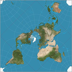
The stereographic projection, also known as the planisphere projection or the azimuthal conformal projection, is a conformal map projection whose use dates back to antiquity. Like the orthographic projection and gnomonic projection, the stereographic projection is an azimuthal projection, and when on a sphere, also a perspective projection.

<span class="mw-page-title-main">Polyhedral map projection</span> Type of map projection

A polyhedral map projection is a map projection based on a spherical polyhedron. Typically, the polyhedron is overlaid on the globe, and each face of the polyhedron is transformed to a polygon or other shape in the plane. The best-known polyhedral map projection is Buckminster Fuller's Dymaxion map. When the spherical polyhedron faces are transformed to the faces of an ordinary polyhedron instead of laid flat in a plane, the result is a polyhedral globe.

References

  1. A Quincuncial Projection of the Sphere by Charles Sanders Peirce. 1890.
    I. Frischauf. Bemerkungen zu C. S. Peirce Quincuncial Projection. (Tr., Comments on C. S. Peirce Quincuncial Projection.)
    A Treatise on Projections by Thomas Craig. U.S. Government Printing Office, 1882. p 132
    Science, Volume 11. Moses King, 1900. p 186
  2. (Lee, 1976) gives 1877 as the year in which the projection was conceived, citing "US Coast Survey Report for the Year Ending with June 1877", 191192.
  3. Lee, L. P. (1976). "Conformal Projections Based on Jacobian Elliptic Functions". Cartographica. 13: 67–101. doi:10.3138/X687-1574-4325-WM62.
  4. Peirce, C.S. (1879). "A quincuncial projection of the sphere". American Journal of Mathematics. 2 (4): 394–396. doi:10.2307/2369491. JSTOR   2369491.
  5. Lee, L.P. (1976). Conformal Projections Based on Elliptic Functions. Cartographica. pp. 67–69.
  6. 1 2 Snyder, John P. (1989). An Album of Map Projections, Professional Paper 1453 (PDF). US Geological Survey. pp. 190, 236.
  7. German, Daniel; d'Angelo, Pablo; Gross, Michael; Postle, Bruno (June 2007). "New Methods to Project Panoramas for Practical and Aesthetic Purposes". Proceedings of Computational Aesthetics 2007. Banff: Eurographics. pp. 15–22.
  8. 1 2 Carlos A. Furuti. Map Projections:Conformal Projections.

Further reading

"The World on a Quincuncial Projection", from Peirce (1879) "A Quincuncial Projection of the Sphere". American Journal of Mathematics, 2 (4): 394-397 Peirce Quincuncial Projection 1879.jpg
"The World on a Quincuncial Projection", from Peirce (1879) "A Quincuncial Projection of the Sphere". American Journal of Mathematics, 2 (4): 394–397