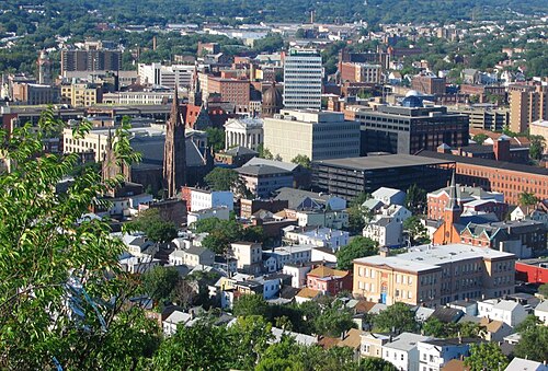
Paterson is the largest city in and the county seat of Passaic County, New Jersey, United States.

Broadway is an neighborhood within the city of Newark in Essex County, New Jersey, United States. It is located on the west bank of the Passaic River, in Newark's North Ward, east of Forest Hill and north of Seventh Avenue. The neighborhood extends from Interstate 280 to Belleville. The term "Broadway" has only come into use recently, most Broadway residents simply refer to their area as part of the North Ward. The street itself "Broadway" was called "Washington Avenue" until the early twentieth century. Today, the area is predominantly Italian American, Puerto Rican and Dominican, with a growing population from other parts of Latin America. The New Jersey Historical Society was located here from the 1930s to 1997. The neo-classical Mutual Benefit building was constructed in the Broadway neighborhood in 1927. The district has many old brownstones in various states of repair. There are high-rise apartment buildings overlooking Branch Brook Park.

Olney is a neighborhood in North Philadelphia, Pennsylvania, United States. It is roughly bounded by Roosevelt Boulevard to the south, Tacony Creek to the east, Godfrey Avenue to the north, and the railroad right-of-way west of Seventh Street to the west.

West Kensington is a neighborhood in the North Philadelphia section of Philadelphia. It is north of Olde Kensington. The Market Frankford El above Front Street forms the line between West Kensington and Kensington. Its bordering neighborhoods are Kensington to the east, Harrowgate to the northeast, and Fairhill to the west. It is bounded by Kensington Avenue to the east, American Street to the west, York Street to the South and Allegheny Avenue to the north.

Feltonville is a working-class neighborhood in North Philadelphia It is located east of Logan and Hunting Park, west of Lawncrest and Juniata, south of Olney, and north of Fairhill and Harrowgate. Feltonville is bounded by Erie Avenue to the south, Front Street to the west, Roosevelt Boulevard to the north, Tacony Creek to the northeast, and G Street to the east.
South Paterson is a neighborhood in Paterson, New Jersey, United States.
Elmwood Park, also known simply as Elmwood, is a neighborhood in the Southwest section of Philadelphia, Pennsylvania, United States. It borders the city line with Delaware County at Cobbs Creek, and extends to the Schuylkill River. The Eastwick neighborhood borders it to the southwest, and Kingsessing borders it on the northeast.
India Square, also known as "Little India," or Little Gujarat, is a commercial and restaurant district in the Journal Square and Marion Section neighborhoods of Jersey City, New Jersey. The area is home to the highest concentration of Asian Indians in the Western Hemisphere, and is a rapidly growing Indian American ethnic enclave within the New York Metropolitan Area. The neighborhood is centered on Newark Avenue, between Tonnele Avenue and JFK Boulevard, and is considered to be part of the larger Journal Square District. This area has been home to the largest outdoor Navratri festivities in New Jersey as well as several Hindu temples. This portion of Newark Avenue is lined with grocery stores including Patel Brothers and Subzi Mandi Cash & Carry, electronics vendors, video stores, clothing stores, and restaurants, and is one of the busiest pedestrian areas of this part of the city, often stopping traffic for hours. According to the 2000 census, there were nearly 13,000 Indians living in this two-block stretch in Jersey City, up from 3,000 in 1980, increasing commensurately between 2000 and 2010. As of the 2010 Census, over 27,000 Asian Indians accounted for 10.9% of Jersey City's population, the highest proportion of any major U.S. city.

The Heights or Jersey City Heights is a district in the north end of Jersey City, New Jersey, atop the New Jersey Palisades overlooking Hoboken to the east and Croxton in the Meadowlands to the west.
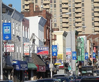
Little Lima is a Peruvian enclave in Downtown Paterson, New Jersey, United States, and the largest Peruvian enclave outside of South America, home to approximately 10,000 Peruvian immigrants, by U.S. Census Bureau estimates. New Jersey's Peruvian population continues to grow in its urban areas, especially in Paterson, which is considered by many to be the capital of the Peruvian Diaspora in the United States. Meanwhile, East Newark, a smaller borough, in Hudson County, New Jersey, has the largest Peruvian percentage in the U.S. per capita, and New Jersey is home to the largest per capita Peruvian American population of any U.S. state.
Downtown Paterson is the main commercial district of Paterson, Passaic County, New Jersey, United States. The area is the oldest part of the city, along the banks of the Passaic River and its Great Falls. It is roughly bounded by Interstate 80, Garret Mountain Reservation, Route 19, Oliver Street, and Spruce Street on the south; the Passaic River, West Broadway, Cliff Street, North 3rd Street, Haledon Avenue, and the borough of Prospect Park on the west; and the Passaic River also to the north.
Eastside is a neighborhood in Paterson, New Jersey, United States. It is bordered by South Paterson, Downtown Paterson, Riverside and the Passaic River It is bound by 10th Avenue and Montgomery Street to the north, Straight Street to the west, I-80 to the south and the river to the east. It is Paterson's largest neighborhood and includes the smaller neighborhoods of Sandy Hill, People's Park, Eastside Park Historic District and the Manor Section. Eastside is a mostly residential area with commercial centers along 33rd Street and Broadway. It is also home to Eastside Park, Paterson's largest park.
Sandy Hill is a neighborhood in Paterson, New Jersey It is located roughly west of Madison Avenue, north of Cedar Street, south of Market Street and east of Straight Street. Due to Paterson's significant population turn-over, this neighborhood is now home to a large Hispanic community, mostly first-generation Dominicans. The Sandy Hill section of Paterson is located in the city's 5th Ward. Roberto Clemente Park, which was originally known as Sandy Hill Park is located in this neighborhood.
Stoney Road is Paterson, New Jersey, USA's most south-west neighborhood and is bordered by Woodland Park to the south and Totowa across the Passaic River to the west. It is bordered on the east by Mountain Avenue and to the north by Rockland Street. And also stoney road is bordered to the south at Glover Avenue This neighborhood is home to Pennington Park, Hayden Heights, Lou Costello Pool, western Grand Street, McBride Avenue and Garrett Heights. The Stoney Road section of Paterson is located in the city's 2nd Ward. A strong Italian presence remains in this neighborhood.

Riverside is a larger neighborhood in Paterson, New Jersey and, as its name states, this neighborhood is bound by the Passaic River to the west, north and east, separating the city from Hawthorne and offering 5 major crossings into the Greater Paterson Borough of Fair Lawn, giving residents access to NJ Transits Urban Local-Hoboken PATH Connect Train Line in the Radburn and Broadway Districts, easily accessible by Bus, car, or walking, as well as keeping Jewish, Muslim, Baptist, Eastern Orthodox, etc. Religious Communities and families within walking distance of relatives, places of Worship, and other points of interests within the East Rivers 07514-07410 neighborhoods. It is loosely bounded in the south by 10th Avenue and Montgomery Street from the Eastside neighborhood, but it is common for anyone who lived, lives, or frequents the area the boundary using the word "Riversude" begins, from South to North, at Broadway to 1st/Maple Ave. and, from West to East, from Madison Ave to River Rd, to call their neighborhood "Riverside" within the sub-Culture of the 07514-07410 East River area, typically referred to as "River Rats", named after the 2 ft Long Rats that can be seen swimming, flipping or basking in the Sun in and around the East River. Riverside is mostly a quiet working-class neighborhood. The neighborhood is mostly residential with some industrial uses. Madison Avenue cuts through the heart of this district, but to many this is a loose boundary with Madison Ave. being the Western boundary, while Route 20 runs through the eastern border of Riverside providing an easy commute to Route 80 East and New York City. However, traditionally "Riverside" ended at River Rd. This section is ethnically diverse with a growing Hispanic community concentrating mostly north and along River Street. African Americans and Caribbean blacks live south of River Street. Many Albanians make their home in the East 18th Street and River Street areas. River View Terrace is located in this neighborhood. Riverside is located in parts of the 3rd and 4th Wards of Paterson.
Lakeview is a neighborhood in the southern part of Paterson, Passaic County, New Jersey in the United States. It is a middle-class neighborhood. Interstate 80 runs north of this district. The Passaic River bounds the district to the east and East Railroad Avenue separates Lakeview from South Paterson. Lakeview is home to the Paterson Farmers Market, where people from all across North Jersey come to buy fresh produce. The neighborhood consists primarily of Hispanics and African Americans, although it also contains large Italian, Middle Eastern, Albanian, and Asian populations, including a significant Filipino presence. Lakeview also shares some of the same traits as neighboring Clifton as they both share the neighborhood bearing the same name. The Lakeview section of Paterson is located in the city's 6th Ward.
Totowa or the Totowa Section of Paterson, New Jersey is a hilly, working to middle-class neighborhood in the northwest corner of the city that borders Totowa and Haledon. It is mostly Hispanic with a rising Bengali population; the area maintains a large minority of African-Americans mostly concentrated in Brooks Sloate Terrace and Italians near the Totowa border. Colonial Village is a large apartment complex located in the neighborhood. John F. Kennedy Educational Complex is located on Preakness Avenue. Many Peruvian and other Latin restaurants and businesses are located on Union Avenue. The Totowa Section is located in parts of the 1st and 2nd Wards of Paterson; it is also known to be one of the safer neighborhoods in the city of Paterson.

Van Vorst Park is an upper income neighborhood in the Historic Downtown of Jersey City, Hudson County, New Jersey, United States, centered on a park sharing the same name. The neighborhood is located west of Paulus Hook and Marin Boulevard, north of Grand Street, east of the Turnpike Extension, and south of The Village and Christopher Columbus Drive. Much of it is included in the Van Vorst Park Historical District.
The U.S. state of New Jersey is home to significant and growing numbers of people of Latino and Hispanic descent, nearly 1.8 million, who in 2018 represented a Census- estimated 20.4% of the state's total population. New Jersey's Latino population comprises substantial concentrations of Dominican Americans, Puerto Rican Americans, Cuban Americans, Mexican Americans, Central Americans, Peruvian Americans, Colombian Americans, and Ecuadorian Americans. New Jersey is also home to a large Brazilian American and Portuguese-speaking population. The state has multiple municipalities with Hispanic-majority populations. Latinos and Hispanics form one-third of the population in the largest city, Newark settling in the Forest Hill, Broadway and Mount Pleasant neighborhoods which comprise mostly of Puerto Ricans and Dominicans. The northern part of Hudson County it was nicknamed Havana on the Hudson for the large number of Cuban exiles and émigrés living there. Little Lima, in Paterson, is the largest Peruvian enclave outside of South America. Many Latino and Hispanic people have been elected to public office in New Jersey, at both the state and local levels.
Perth Amboy, New Jersey is located at the mouth of the Raritan River and the Arthur Kill at the Raritan Bay, and is part of the region known as the Raritan Bayshore.