Related Research Articles

Paterson is the largest city in and the county seat of Passaic County, New Jersey, United States.
Passaic County Community College is a public community college in Passaic County, New Jersey, United States.

Roseville is an unincorporated community and neighborhood within the city of Newark in Essex County, New Jersey, United States. It borders Bloomfield and East Orange. To the neighborhood's immediate east is the Newark City Subway and Branch Brook Park. Roseville is divided into Upper Roseville north of 3rd Ave and Lower Roseville south of 3rd Ave.
South Paterson is a neighborhood in Paterson, New Jersey, United States.
India Square, also known as "Little India," is a commercial and restaurant district in the Journal Square and Marion Section neighborhoods of Jersey City, New Jersey. The area is home to the highest concentration of Asian Indians in the Western Hemisphere, and is a rapidly growing Indian American ethnic enclave within the New York Metropolitan Area. The neighborhood is centered on Newark Avenue, between Tonnele Avenue and JFK Boulevard, and is considered to be part of the larger Journal Square District. This area has been home to the largest outdoor Navratri festivities in New Jersey as well as several Hindu temples. This portion of Newark Avenue is lined with grocery stores including Patel Brothers and Subzi Mandi Cash & Carry, electronics vendors, video stores, clothing stores, and restaurants, and is one of the busiest pedestrian areas of this part of the city, often stopping traffic for hours. According to the 2000 census, there were nearly 13,000 Indians living in this two-block stretch in Jersey City, up from 3,000 in 1980, increasing commensurately between 2000 and 2010. As of the 2010 Census, over 27,000 Asian Indians accounted for 10.9% of Jersey City's population, the highest proportion of any major U.S. city.

The Heights or Jersey City Heights is a district in the north end of Jersey City, New Jersey, atop the New Jersey Palisades overlooking Hoboken to the east and Croxton in the Meadowlands to the west.
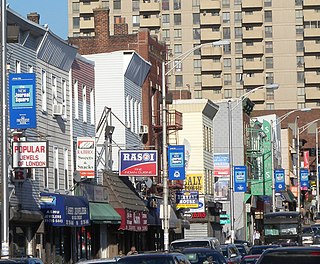
Little Lima is a Peruvian enclave in Downtown Paterson, New Jersey, United States, and the largest Peruvian enclave outside of South America, home to approximately 10,000 Peruvian immigrants, by U.S. Census Bureau estimates. New Jersey's Peruvian population continues to grow in its urban areas, especially in Paterson, which is considered by many to be the capital of the Peruvian Diaspora in the United States. Meanwhile, East Newark, a smaller borough, in Hudson County, New Jersey, has the largest Peruvian percentage in the U.S. per capita, and New Jersey is home to the largest per capita Peruvian American population of any U.S. state.
Dublin is a former Irish-American neighborhood in Paterson, New Jersey that makes up Little Lima and Little Italy today. Dublin was Paterson's first distinct neighborhood that grew up around the mills along the east bank of the Passaic River in Downtown Paterson. Alexander Hamilton established the Society for the Establishment of Useful Manufactures (S.U.M.), which helped to harness the power of Great Falls in 1791. In the early 19th century there were several mills and machine shops along the Passaic, downriver from the falls. A grid of streets were laid out by Pierre L'Enfant for the housing of millworkers in the area. The area then known as Dublin was bound by the Morris Canal, Garret Mountain, and Main Street with a populated area along Market Street. In the early 20th century a growing Italian workforce in the area created the Little Italy neighborhood around Cianci Street. Some of the old mill buildings of the area have been converted into housing and retail in addition to the Paterson Museum.
Downtown Paterson is the main commercial district of Paterson, Passaic County, New Jersey, United States. The area is the oldest part of the city, along the banks of the Passaic River and its Great Falls. It is roughly bounded by Interstate 80, Garret Mountain Reservation, Route 19, Oliver Street, and Spruce Street on the south; the Passaic River, West Broadway, Cliff Street, North 3rd Street, Haledon Avenue, and the borough of Prospect Park on the west; and the Passaic River also to the north.
Northside is a neighborhood in Paterson NJ. It includes the entire area of downtown north of the Passaic River. It suffers from some of the social problems currently facing the Wrigley Park neighborhood but to a lesser extent. This neighborhood borders Haledon and Prospect Park and it is known for its hills and having sweeping views of New York City. The Northside section of Paterson is located in the city's 1st Ward. Northside is home to the local branch of Habitat for Humanity.
Eastside is a neighborhood in Paterson, New Jersey, United States. It is bordered by South Paterson, Downtown Paterson, Riverside and the Passaic River It is bound by 10th Avenue and Montgomery Street to the north, Straight Street to the west, I-80 to the south and the river to the east. It is Paterson's largest neighborhood and includes the smaller neighborhoods of Sandy Hill, People's Park, Eastside Park Historic District and the Manor Section. Eastside is a mostly residential area with commercial centers along 33rd Street and Broadway. It is also home to Eastside Park, Paterson's largest park.
Sandy Hill is a neighborhood in Paterson, New Jersey It is located roughly west of Madison Avenue, north of Cedar Street, south of Market Street and east of Straight Street. Due to Paterson's significant population turn-over, this neighborhood is now home to a large Hispanic community, mostly first-generation Dominicans. The Sandy Hill section of Paterson is located in the city's 5th Ward. Roberto Clemente Park, which was originally known as Sandy Hill Park is located in this neighborhood.
People's Park is a section of Paterson, New Jersey, United States, in the Eastside neighborhood. It is a mixed use area with a diverse population. It is roughly bounded by I-80 to the south, Madison Avenue to the west and Market Street to the north. It is a mostly residential neighborhood located north of 23rd Avenue and South of Market Street.
The Old Great Falls Historic District is an area of Paterson, New Jersey between South Paterson and Hillcrest, Paterson. The area is a thin strip of neighborhoods and parklands around the Passaic River and Garret Mountain. This section of Paterson has two National Natural Landmarks, Garret Mountain and Great Falls on the Passaic. It is the location of the highest point in Paterson. It is home to Lambert Castle and Alexander Hamilton's Society for the Establishment of Useful Manufactures (S.U.M.), which used the force of Great Falls to power the mills along the Passaic in the Dublin section. The neighborhood is also home to part of Garret Mountain Reservation and Overlook Park around the Grand Street Reservoir. The neighborhood is bounded by the border with Hillcrest by the Passaic River, by the Woodland Park border, the South Paterson border along Valley Road and Route 19. It is separated from Downtown Paterson to the north by Route 19, Oliver Street and Spruce Street.
Stoney Road is Paterson, New Jersey, USA's most south-west neighborhood and is bordered by Woodland Park to the south and Totowa across the Passaic River to the west. It is bordered on the east by Mountain Avenue and to the north by Rockland Street. And also stoney road is bordered to the south at Glover Avenue This neighborhood is home to Pennington Park, Hayden Heights, Lou Costello Pool, western Grand Street, McBride Avenue and Garrett Heights. The Stoney Road section of Paterson is located in the city's 2nd Ward. A strong Italian presence remains in this neighborhood.
Lakeview is a neighborhood in the southern part of Paterson, Passaic County, New Jersey in the United States. It is a middle-class neighborhood. Interstate 80 runs north of this district. The Passaic River bounds the district to the east and East Railroad Avenue separates Lakeview from South Paterson. Lakeview is home to the Paterson Farmers Market, where people from all across North Jersey come to buy fresh produce. The neighborhood consists primarily of Hispanics and African Americans, although it also contains large Italian, Middle Eastern, Albanian, and Asian populations, including a significant Filipino presence. Lakeview also shares some of the same traits as neighboring Clifton as they both share the neighborhood bearing the same name. The Lakeview section of Paterson is located in the city's 6th Ward.
The Village is a neighborhood in the western section of Historic Downtown in Jersey City. It is bordered by Hamilton Park and Harsimus Cove to the east and the Turnpike Extension to the west, on the other side of which Jones Park and Mary Benson Park are located. Newark Avenue is the major street across the Village from Grove Street at the east to Bergen Hill at the west. The neighborhood for many years was considered the city's "Little Italy" neighborhood. Brunswick Street, between 1st and 10th Streets was once full of merchants and nicknamed "Bushel Avenue". St. Anthony of Padua Roman Catholic Church at 457 Monmouth St. received its historic designation on March 22, 2004.

Transfer Station is the name of a section of Hudson County, New Jersey, which radiates from the intersection where Paterson Plank Road crosses Summit Avenue at 7th Street. It is near the tripoint where the borders of Jersey City Heights, North Bergen, and Union City intersect, which is a few blocks to the southwest of the station, at the intersection of Secaucus Road and Kennedy Boulevard.
References
- ↑ Eftimiades, Maria (30 Nov 1988). "In Paterson, fresh cannolis and cafe society". The Record. Hackensack, New Jersey. p. E1. Retrieved 30 Dec 2021.
Tucked away behind the hustle and bustle of Market Street in downtown Paterson, Little Italy encompasses three square blocks from Cianci to Passaic streets.
- ↑ Batelli, Michael (2 Jan 1967). "Talking A Walk: Handshake A Memory". The Morning Call. Paterson, New Jersey. p. 6. Retrieved 30 Dec 2021.
Coordinates: 40°54′57″N74°10′30″W / 40.915799°N 74.174924°W
| |
| | This Passaic County, New Jersey state location article is a stub. You can help Wikipedia by expanding it. |