Downtown Paterson is the main commercial district of Paterson, Passaic County, in the U.S. state of New Jersey. The area is the oldest part of the city, along the banks of the Passaic River and its Great Falls. It is roughly bounded by Interstate 80, Garret Mountain Reservation, Route 19, Oliver Street, and Spruce Street on the south; the Passaic River, West Broadway, Cliff Street, North 3rd Street, Haledon Avenue, and the borough of Prospect Park on the west; and the Passaic River also to the north.
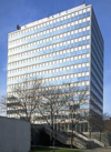
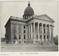
After a devastating fire in 1902, the city rebuilt the downtown with massive Beaux-Arts-style buildings, many of which remain to this day. [1] [2] [3] and are contributing properties to the Downtown Commercial Historic District. [4] These buildings are usually four to seven stories tall. Downtown Paterson is home to City Hall and the Passaic County Court House, two of the city's architectural landmarks. City Hall was designed by the New York firm Carrere and Hastings in 1894 and is modeled after the Hôtel de Ville (city hall) in Lyon, France, capital of the silk industry in Europe. Downtown abounds with buildings designed by Fred Wesley Wentworth, some in collaboration with his draftsman and later partner Frederick J. Vreeland, who worked in the city from the turn of the century to the 1930s. [5] [6] The Cathedral of St. John the Baptist survived the fire. As the county seat Paterson is home to the Passaic County Court House complex, Passaic County Community College, and several federal and state offices. Center City Mall is a 320,000-square-foot (30,000 m2) shopping mall at 301 Main Street opened in 2009, and is home to the acclaimed Hamilton & Ward Steakhouse. The massive Masjid Jalalabad mosque, which can accommodate 1,500 worshippers, is located on Van Houten Street. Paterson Broadway Bus Terminal is a major regional bus terminal. Downtown has a diverse ethnic makeup with large Dominican, Puerto Rican, Peruvian, and Mexican populations. Little Lima is the largest Peruvian American enclave in the United States. [7]
Paterson Downtown Commercial Historic District | |
Location | Parts of Main, Market, Ellison, Van Houten, Broadway, West Broadway, Fair, Prospect, Cianci, Church, Colt, Washington and Hamilton streets |
---|---|
Coordinates | 40°55′2″N74°10′21″W / 40.91722°N 74.17250°W |
Area | 41 acres (17 ha) |
Built | 1851 |
Architect | John Merven Carrère, Thomas Hastings |
Architectural style | Beaux Arts, Romanesque |
NRHP reference No. | 99000192 [8] |
NJRHP No. | 170 [9] |
Significant dates | |
Added to NRHP | February 12, 1999 |
Designated NJRHP | December 15, 1998 |
The Paterson Downtown Commercial Historic District is a 41-acre (17 ha) historic district containing parts of Main, Market, Ellison, Van Houten, Broadway, West Broadway, Fair, Prospect, Cianci, Church, Colt, Washington and Hamilton streets in downtown Paterson. It was added to the National Register of Historic Places on February 12, 1999 for its significance in architecture, commerce, and community planning and development. The district includes 210 contributing buildings and one contributing object. It includes the Paterson City Hall, which was added individually to the NRHP in 1995. [10] The Paterson Great Falls National Historical Park and Public School Number Two are located nearby.
Rank | Name | Address | image | Height m/ft | Floors | Year | Notes |
---|---|---|---|---|---|---|---|
1 | Alexander Hamilton Plaza | 100 Hamilton Plaza | 53.65 m (176.0 ft) | 14 | 1973 | named for Alexander Hamilton [11] | |
The Hamiltonian [12] Medical Missions for Children | 703 Main Street | 51.59 m (169.3 ft) | 14 | 2014 construction start 2016 projected completion | DoubleTree [13] [14] [15] [16] | ||
2 | Cathedral of St. John the Baptist | 381 Grand Street | spire | 1868 | by Patrick Keely [17] | ||
3 | Paterson City Hall | 155 Market Street | 49.99 m (164.0 ft) | tower | 1896 | by Carrère and Hastings [18] | |
St. Joseph's Regional Medical Center | 703 Main Street | 39.62 m (130.0 ft) | 9 | 1928 | [19] | ||
Passaic County Court House Annex | Hamilton Street | spire | 1898 | by F.W. Wentworth [20] [21] | |||
Old Passaic County Court House | 71 Hamilton Street | dome and statue | 1898 | by Samuel B. Reed [21] [22] | |||
YMCA Building | 128 Ward Street | 33.16 m (108.8 ft) | 9 | 1929 | by F.W. Wentworth [23] | ||
Passaic County Administration Building | 401 Grand Street | 33.16 m (108.8 ft) | 9 | 1994 | [20] [21] | ||
Fabian Building | 31-51 Church Street | 29.48 m (96.7 ft) | 9 | 1925 | for Jacob Fabian by F.W. Wentworth [24] | ||
Alexander Hamilton Hotel | 39-55 Church Street | 29.48 m (96.7 ft) | 8 | 1925 | by F.W. Wentworth [25] | ||
Center City Mall | 301 Main Street | 25.79 m (84.6 ft) | 5 | 2009 | [26] | ||
Passaic County Court House | 77 Hamilton Street | 25.79 m (84.6 ft) | 7 | 1968 | [27] | ||
Robert A. Roe Federal Building | 200 Federal Plaza | 22.11 m (72.5 ft) | 6 | for Robert A. Roe [28] [29] |
The central business district of Paterson is the area closest to the Passaic River on the west side of the city. The areas along Market Street and Main Street are some of the busiest and largest commercial districts in Paterson. Downtown was once a shopping mecca for northern New Jersey. As with many other older urban cores in the United States, it suffered as shoppers and retailers moved to the suburban shopping malls of the region. For a large part, Downtown retailers are "mom and pop" retailers who employee local residents. In 1997, a special improvement district (SID) created by Merchants and Businesses of Downtown Paterson, [30] comprising over 300 stakeholders, updated storefronts and beautified city streets with signage and lighting. Downtown SID employees supplement the municipal cleaning, informational, and safety services of the city by maintaining a "Clean and Safe" staff. The association participates in many city activities with sponsorships such as the Great Falls Festival and the annual 4th of July fireworks show, one of Northern New Jersey's largest. Additionally, the SID implements several events throughout the year in Downtown Paterson. Downtown Paterson was an Urban Enterprise Zone (UEZ), which means that participating stores sell merchandise at 3.5% sales tax, instead of the normal 7% sales tax. The UEZ also invested greatly in Downtown Paterson and the entire stretch of Main Street, with a beautification project. New street furniture such as benches, garbage cans, newspaper kiosks, bus shelters, clocks, bike racks have been installed.
Dublin, considered the first neighborhood of Paterson, was built up around the mills near Great Falls. The area, which is responsible for the early growth of Paterson, has a rich history and has had a diverse and changing ethnic makeup. Originally settled by Irish immigrants, the neighborhood has seen waves of English, Italians and more recently Hispanic immigrants. The Dublin area today incorporates parts of Old Great Falls Historic District and the area on Market Street, which has a large Peruvian and Argentine population today.
Wrigley Park is the northern section of downtown, north of Broadway and to the east of the Passaic River. Wrigley Park is a predominantly African-American community and is mostly residential. The area is considered to be one of the more dangerous sections of Paterson along with areas of the Northside,[ citation needed ] although the crime rate has declined gradually in recent years. [31]
Northside is a mostly residential neighborhood on the north bank of the Passaic River. The neighborhood stretches back to Paterson's borders with Haledon and Prospect Park. The neighborhoods on this side of the river are up a steep hill that gives many of the houses and streets in the Northside great views of Manhattan.
Train service began with the Paterson and Hudson River Railroad in 1833. Erie Railroad ran service on its Newark Branch and Main Line. The Paterson rail station is located in Downtown. Paterson is served by New Jersey Transit on the Main Line and limited service on the Port Jervis Line.
The Broadway Bus Terminal is the point of origin for numerous New Jersey Transit Bus Operations' local and Manhattan-bound bus lines.
Interstate 80 passes south of Downtown. New Jersey Route 19, known as the Paterson Peripheral, connects Interstate 80 and the Garden State Parkway to Downtown where it becomes Ward Street.
Route 20, known locally as McLean Boulevard, is a state highway that runs 4.15 miles (6.68 km) in New Jersey, United States. It runs along the east side of Paterson, Passaic County, following the west bank of the Passaic River between U.S. Route 46 and River Street, at which point County Route 504 begins. It is a four- to six-lane divided highway for most of its length that runs through residential and commercial areas of Paterson, intersecting with Interstate 80 and Route 4 at interchanges. The northernmost part of the route is a county-maintained one-way pair that follows 1st and 2nd Avenues.
Passaic is a city in Passaic County, in the U.S. state of New Jersey. As of the 2020 United States census, the city was the state's 16th-most-populous municipality, with a population of 70,537, falling behind Bayonne, an increase of 756 (+1.1%) from the 2010 census count of 69,781, which in turn reflected an increase of 1,920 residents (+2.8%) from the 2000 census population of 67,861. The Census Bureau's Population Estimates Program calculated that the city's population was 69,128 in 2022, ranking the city the 546th-most-populous in the country. Among cities with more than 50,000 people, Passaic was the fifth-most-densely-populated municipality in the United States, with more than 22,000 people per square mile.
Paterson is the largest city in and the county seat of Passaic County, in the U.S. state of New Jersey. As of the 2020 United States census, the city was the state's third-most-populous municipality, with a population of 159,732.
The Passaic River is a river, approximately 80 miles (130 km) long, in Northern New Jersey. The river in its upper course flows in a highly circuitous route, meandering through the swamp lowlands between the ridge hills of rural and suburban northern New Jersey, called the Great Swamp, draining much of the northern portion of the state through its tributaries.
The Great Falls of the Passaic River is a prominent waterfall, 77 feet (23 m) high, on the Passaic River in the city of Paterson in Passaic County, New Jersey. The falls and surrounding area are protected as part of the Paterson Great Falls National Historical Park, administered by the National Park Service. The Congress authorized its establishment in 2009.
Paterson Plank Road is a road that runs through Passaic, Bergen and Hudson Counties in northeastern New Jersey. The route, originally laid in the colonial era, connects the city of Paterson and the Hudson River waterfront. It has largely been superseded by Route 3, but in the many towns it passes it has remained an important local thoroughfare, and in some cases been renamed.
Downtown Spokane or Riverside is the central business district of Spokane, Washington. The Riverside neighborhood is roughly bounded by I-90 to the south, Division Street to the east, Monroe Street to the west and Boone Avenue to the north. The topography of Downtown Spokane is mostly flat except for areas downstream of the Spokane Falls which are located in a canyon; the elevation is approximately 1,900 feet (580 m) above sea level.
Little Lima is a Peruvian enclave in Downtown Paterson, New Jersey, United States, and the largest Peruvian enclave outside of South America, home to approximately 10,000 Peruvian immigrants, by U.S. Census Bureau estimates. New Jersey's Peruvian population continues to grow in its urban areas, especially in Paterson, which is considered by many to be the capital of the Peruvian Diaspora in the United States. Meanwhile, East Newark, a smaller borough, in Hudson County, New Jersey, has the largest Peruvian percentage in the U.S. per capita, and New Jersey is home to the largest per capita Peruvian American population of any U.S. state.
Eastside is a neighborhood in Paterson, New Jersey, in the U.S. state of New Jersey. It is bordered by South Paterson, Downtown Paterson, Riverside and the Passaic River It is bound by 10th Avenue and Montgomery Street to the north, Straight Street to the west, Interstate 80 to the south and the river to the east. It is Paterson's largest neighborhood and includes the smaller neighborhoods of Sandy Hill, People's Park, Eastside Park Historic District and the Manor Section. Eastside is a mostly residential area with commercial centers along 33rd Street and Broadway. It is also home to Eastside Park, Paterson's largest park.
Eastside Park is a residential neighborhood in the Eastside of Paterson, New Jersey. The Eastside Park section of the city is generally defined as the area of the city bordered by Vreeland Avenue and East 33rd Street to the west, 20th Avenue to the south, McLean Boulevard to the east, and Martin Luther King, Jr. Way (Broadway) to the north. The Eastside Park section is delineated from the Manor section of the city by Broadway, which becomes Route 4 before crossing the Passaic River into Elmwood Park in Bergen County.
The Old Great Falls Historic District is an area of Paterson, New Jersey between South Paterson and Hillcrest, Paterson. The area is a thin strip of neighborhoods and parklands around the Passaic River and Garret Mountain. This section of Paterson has two National Natural Landmarks, Garret Mountain and Great Falls on the Passaic. It is the location of the highest point in Paterson. It is home to Lambert Castle and Alexander Hamilton's Society for the Establishment of Useful Manufactures (S.U.M.), which used the force of Great Falls to power the mills along the Passaic in the Dublin section. The neighborhood is also home to part of Garret Mountain Reservation and Overlook Park around the Grand Street Reservoir. The neighborhood is bounded by the border with Hillcrest by the Passaic River, by the Woodland Park border, the South Paterson border along Valley Road and Route 19. It is separated from Downtown Paterson to the north by Route 19, Oliver Street and Spruce Street.
Downtown Columbus, Georgia, also called "Uptown", is the central business district of the city of Columbus, Georgia. The commercial and governmental heart of the city has traditionally been toward the eastern end of Downtown Columbus, between 10th Street and 1st Avenue. Recent developments, particularly between Broadway and 2nd Avenue, have expanded the boundaries of the "central" part of the neighborhood. The term "Downtown Columbus" can also mean this smaller, more commercial area, particularly when used in the context of the city's nightlife and restaurants.
The Broadway Bus Terminal is a major local and regional bus terminal in Paterson, New Jersey operated by New Jersey Transit. It is located on Broadway between Memorial Drive and West Broadway in Downtown Paterson, putting it near Passaic County Community College and a few blocks from Paterson City Hall and the Great Falls Historic District, including the Great Falls.
Paterson City Hall is located at 155 Market Street in Paterson, Passaic County, New Jersey. The building is located on a block in Downtown Paterson bordered by Market Street on the north, Colt Street to the east, Ellison Street to the south, and Washington Street to the west.
Danforth Memorial Library, also known as the Paterson Free Public Library, is located at 250 Broadway in the city of Paterson in Passaic County, New Jersey, United States. The library was built in 1905 and was added to the National Register of Historic Places on March 1, 1984, for its significance in architecture, education, and social history.
The Four Corners Historic District is the intersection of Broad and Market Streets in Newark, New Jersey. It is the site of the city's earliest settlement and the heart of Downtown Newark that at one time was considered the busiest intersection in the United States. The area that radiates twenty-two square blocks from the crossroads is a state and federal historic district.
The Passaic County Court House complex is located at the seat of Passaic County, New Jersey in Paterson.
Fred Wesley Wentworth was an American architect known for his many buildings in Downtown Paterson, New Jersey, as well as several residences and theaters in northeastern New Jersey. Wentworth had a major impact on shaping Paterson after a wind-driven fire decimated much of the central business district in 1902. His body of work consisted of institutional, commercial, residential, religious and healthcare buildings as well as some of the nation's first movie theaters designed exclusively for motion pictures. He was a Fellow of the American Institute of Architects.
Arch Street Bridge is Parker truss bridge over the Passaic River in Paterson, New Jersey. It was built in 1907 and rehabilitated in 1997. It was the third structure built at the location within a few years, the other having been destroyed by floods in 1902 and 1903. The bridge was once a crossing for the Public Service trolley lines.