Perley, Minnesota

Last updated

Perley, Minnesota
Perley, Minnesota at the intersection of US Highway 75 and Norman County Highway 39.jpg
Perley, Minnesota at the intersection of US Highway 75 and Norman County Highway 39
Norman County Minnesota Incorporated and Unincorporated areas Perley Highlighted.svg
Location of Perley, Minnesota
Coordinates: 47°10′37″N96°48′11″W / 47.17694°N 96.80306°W / 47.17694; -96.80306
CountryUnited States
State Minnesota
County Norman
Incorporated September 27, 1906
Government
   Mayor Ann L. Kruse
Area
[1]
  Total0.247 sq mi (0.640 km2)
  Land0.247 sq mi (0.640 km2)
  Water0.000 sq mi (0.000 km2)
Elevation
[2]
876 ft (267 m)
Population
 (2020) [3]
  Total113
  Estimate 
(2022) [4]
110
  Density457.49/sq mi (176.29/km2)
Time zone UTC-6 (Central (CST))
  Summer (DST) UTC-5 (CDT)
ZIP Code
56574
Area code 218
FIPS code 27-50506
GNIS feature ID0649302 [2]
Sales tax 7.375% [5]

Perley is a city in Norman County, Minnesota, United States. Its population was 113 at the 2020 census. [3]

Contents

History

A post office called Perley has been in operation since 1885. [6] The city was named for George Edmund Perley, a local attorney. [7]

Geography

According to the United States Census Bureau, the city has a total area of 0.247 square miles (0.64 km2), all land. [1]

Demographics

Historical population
CensusPop.Note
1910 188
1920 22218.1%
1930 2314.1%
1940 2466.5%
1950 204−17.1%
1960 165−19.1%
1970 149−9.7%
1980 134−10.1%
1990 132−1.5%
2000 121−8.3%
2010 92−24.0%
2020 11322.8%
2022 (est.)110 [4] −2.7%
U.S. Decennial Census [8]
2020 Census [3]

As of 2000, the median income for a household in the city was $31,250, and the median income for a family was $35,625. Males had a median income of $21,528 versus $19,063 for females. The per capita income for the city was $13,998. There were 10.5% of families and 12.2% of the population living below the poverty line, including 23.7% of under eighteens and none of those over 64.

2010 census

As of the 2010 census, there were 92 people, 48 households, and 28 families residing in the city. The population density was 383.3 inhabitants per square mile (148.0/km2). There were 53 housing units at an average density of 220.8 per square mile (85.3/km2). The racial makeup of the city was 93.5% White, 1.1% Native American, 3.3% from other races, and 2.2% from two or more races. Hispanic or Latino of any race were 7.6% of the population.

There were 48 households, of which 16.7% had children under the age of 18 living with them, 50.0% were married couples living together, 6.3% had a female householder with no husband present, 2.1% had a male householder with no wife present, and 41.7% were non-families. 39.6% of all households were made up of individuals, and 6.3% had someone living alone who was 65 years of age or older. The average household size was 1.92 and the average family size was 2.50.

The median age in the city was 48 years. 15.2% of residents were under the age of 18; 4.3% were between the ages of 18 and 24; 22.8% were from 25 to 44; 39.2% were from 45 to 64; and 18.5% were 65 years of age or older. The gender makeup of the city was 52.2% male and 47.8% female.

Related Research Articles

<span class="mw-page-title-main">Comstock, Minnesota</span> City in Minnesota, United States

Comstock is a city in Clay County, Minnesota, United States. The population was 100 at the 2020 census.

<span class="mw-page-title-main">Georgetown, Minnesota</span> City in Minnesota, United States

Georgetown is a city in Clay County, Minnesota, United States, along the Buffalo River near its confluence with the Red River of the North. The population was 86 at the 2020 census.

<span class="mw-page-title-main">Trommald, Minnesota</span> City in Minnesota, United States

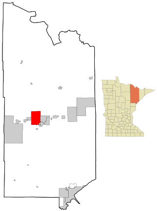
Trommald is a city in Crow Wing County, Minnesota, United States. The population was 99 at the 2020 census. It is part of the Brainerd Micropolitan Statistical Area.

<span class="mw-page-title-main">Donaldson, Minnesota</span> City in Minnesota, United States

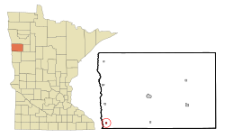
Donaldson is a city in Kittson County, Minnesota, United States. The population was 20 at the 2020 census.

<span class="mw-page-title-main">Hallock, Minnesota</span> City in Minnesota, United States

Hallock is a city in and the county seat of Kittson County, Minnesota, United States. The population was 906 at the 2020 census.

<span class="mw-page-title-main">Viking, Minnesota</span> City in Minnesota, United States

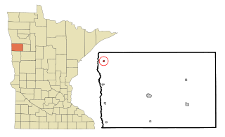
Viking is a city in Marshall County, Minnesota, United States. The population was 79 at the 2020 census.

<span class="mw-page-title-main">Sargeant, Minnesota</span> City in Minnesota, United States

Sargeant is a city in Mower County, Minnesota, United States. The population was 63 at the 2020 census.

<span class="mw-page-title-main">Borup, Minnesota</span> City in Minnesota, United States

Borup is a city in Norman County, Minnesota, United States. The population was 96 at the 2020 census.

<span class="mw-page-title-main">Shelly, Minnesota</span> City in Minnesota, United States

Shelly is a city in Norman County, Minnesota, United States. The population was 179 at the 2020 census.

<span class="mw-page-title-main">Beltrami, Minnesota</span> City in Minnesota, United States

Beltrami is a city in Polk County, Minnesota, United States and was named in honor of Giacomo Costantino Beltrami, an Italian exile, who traveled to the Red river and the upper Mississippi in 1823. Officially incorporated on September 11, 1901, there had been settlers in the area since 1870. It is part of the Grand Forks, ND-MN Metropolitan Statistical Area. The population was 88 at the 2020 census.

<span class="mw-page-title-main">Lengby, Minnesota</span> City in Minnesota, United States

Lengby is a city in Polk County, Minnesota, United States. It is part of the Grand Forks ND-MN Metropolitan Statistical Area. The population was 92 at the 2020 census.

<span class="mw-page-title-main">Mentor, Minnesota</span> City in Minnesota, United States

Mentor is a city in Polk County, Minnesota, United States. It is part of the Grand Forks-ND-MN Metropolitan Statistical Area. The population was 104 at the 2020 census. The city is near Maple Lake.

<span class="mw-page-title-main">Nielsville, Minnesota</span> City in Minnesota, United States

Nielsville is a city in Polk County, Minnesota, United States. It is part of the Grand Forks, ND-MN Metropolitan Statistical Area. The population was 78 at the 2020 census.

<span class="mw-page-title-main">Cook, Minnesota</span> City in Minnesota, United States

Cook is a city in Saint Louis County, Minnesota, United States. The population was 515 at the 2010 census.

<span class="mw-page-title-main">Iron Junction, Minnesota</span> City in Minnesota, United States

Iron Junction is a city in Saint Louis County, Minnesota, United States. The population was 110 at the 2020 census.

<span class="mw-page-title-main">Mountain Iron, Minnesota</span> City in Minnesota, United States

Mountain Iron is a city in Saint Louis County, Minnesota, United States, in the heart of the Mesabi Range. The population was 2,878 at the 2020 census.

<span class="mw-page-title-main">Wolverton, Minnesota</span> City in Minnesota, United States

Wolverton is a city in Wilkin County, Minnesota, United States. The population was 128 at the 2020 census. It is part of the Wahpeton, ND—MN Micropolitan Statistical Area.

<span class="mw-page-title-main">Millerville, Minnesota</span> City in Minnesota, United States

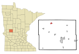
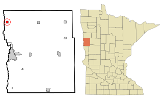
Millerville is a city in Douglas County, Minnesota, United States. The population was 100 at the 2020 census.

<span class="mw-page-title-main">Strandquist, Minnesota</span> City in Minnesota, United States

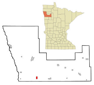
Strandquist is a city in Lincoln Township of Marshall County, Minnesota, United States. The population was 70 at the 2020 census.

<span class="mw-page-title-main">Eden Valley, Minnesota</span> City in Minnesota, United States

Eden Valley is a city in Meeker and Stearns counties in the U.S. state of Minnesota. The population was 1,027 at the 2020 census. Most of Eden Valley is in Meeker County; the Stearns County portion is part of the St. Cloud Metropolitan Statistical Area.

References

  1. 1 2 "2023 U.S. Gazetteer Files". United States Census Bureau. Retrieved February 28, 2024.
  2. 1 2 U.S. Geological Survey Geographic Names Information System: Perley, Minnesota
  3. 1 2 3 "Explore Census Data". United States Census Bureau . Retrieved February 28, 2024.
  4. 1 2 "City and Town Population Totals: 2020–2022". United States Census Bureau. February 28, 2024. Retrieved February 28, 2024.
  5. "Perley (MN) sales tax rate" . Retrieved February 28, 2024.
  6. "Norman County". Jim Forte Postal History. Retrieved July 26, 2015.
  7. Upham, Warren (1920). Minnesota Geographic Names: Their Origin and Historic Significance. Minnesota Historical Society. p.  383.
  8. "Census of Population and Housing". United States Census Bureau. Retrieved June 4, 2015.

47°10′40″N96°48′19″W / 47.17778°N 96.80528°W / 47.17778; -96.80528