Twin Valley, Minnesota

Last updated
Twin Valley
Motto: 
"A Great Place To Live"
Norman County Minnesota Incorporated and Unincorporated areas Twin Valley Highlighted.svg
Location of Twin Valley, Minnesota
Coordinates: 47°15′35″N96°15′26″W / 47.25972°N 96.25722°W / 47.25972; -96.25722
CountryUnited States
State Minnesota
County Norman
Area
[1]
  Total0.85 sq mi (2.21 km2)
  Land0.85 sq mi (2.21 km2)
  Water0.00 sq mi (0.00 km2)
Elevation
1,093 ft (333 m)
Population
 (2020) [2]
  Total723
  Estimate 
(2021) [3]
718
  Density845.61/sq mi (326.50/km2)
Time zone UTC-6 (CST)
  Summer (DST) UTC-5 (CDT)
ZIP code
56584
Area code 218
FIPS code 27-65938
GNIS feature ID0653465 [4]
Website twinvalley.gov

Twin Valley is a city in Norman County, Minnesota, United States, along the Wild Rice River. The population was 723 at the 2020 census. [2]

Contents

Minnesota State Highway 32 and County Highway 31 are two of the main routes in the community. Minnesota State Highway 200 is nearby. The Agassiz Recreational Trail passes through Twin Valley. [5]

History

A post office called Twin Valley has been in operation since 1878. [6] The city was named for its location in a valley where the Wild Rice River is met by a smaller stream. [7]

Geography

According to the United States Census Bureau, the city has an area of 0.87 square miles (2.25 km2), all land. [8]

Demographics

Historical population
CensusPop.Note
1900 356
1910 54352.5%
1920 67624.5%
1930 657−2.8%
1940 84428.5%
1950 8996.5%
1960 841−6.5%
1970 8683.2%
1980 9074.5%
1990 821−9.5%
2000 8655.4%
2010 821−5.1%
2020 723−11.9%
2021 (est.)718 [3] −0.7%
U.S. Decennial Census [9]
2020 Census [2]

2010 census

As of the census of 2010, there were 821 people, 357 households, and 193 families living in the city. The population density was 943.7 inhabitants per square mile (364.4/km2). There were 431 housing units at an average density of 495.4 per square mile (191.3/km2). The racial makeup of the city was 94.4% White, 3.2% Native American, 0.7% from other races, and 1.7% from two or more races. Hispanic or Latino of any race were 2.1% of the population.

There were 357 households, of which 25.8% had children under the age of 18 living with them, 40.3% were married couples living together, 8.1% had a female householder with no husband present, 5.6% had a male householder with no wife present, and 45.9% were non-families. 43.4% of all households were made up of individuals, and 28.3% had someone living alone who was 65 years of age or older. The average household size was 2.17 and the average family size was 2.96.

The median age in the city was 46.8 years. 24.2% of residents were under the age of 18; 5.2% were between the ages of 18 and 24; 18.6% were from 25 to 44; 22.4% were from 45 to 64; and 29.7% were 65 years of age or older. The gender makeup of the city was 48.5% male and 51.5% female.

2000 census

As of the census of 2000, there were 865 people, 360 households, and 192 families living in the city. The population density was 987.0 inhabitants per square mile (381.1/km2). There were 399 housing units at an average density of 455.3 per square mile (175.8/km2). The racial makeup of the city was 94.68% White, 0.23% African American, 2.54% Native American, 0.58% from other races, and 1.97% from two or more races. Hispanic or Latino of any race were 2.31% of the population.

There were 360 households, out of which 24.4% had children under the age of 18 living with them, 42.5% were married couples living together, 9.2% had a female householder with no husband present, and 46.4% were non-families. 43.6% of all households were made up of individuals, and 30.3% had someone living alone who was 65 years of age or older. The average household size was 2.11 and the average family size was 2.93.

In the city, the population was spread out, with 20.3% under the age of 18, 8.2% from 18 to 24, 18.4% from 25 to 44, 16.8% from 45 to 64, and 36.3% who were 65 years of age or older. The median age was 48 years. For every 100 females, there were 87.2 males. For every 100 females age 18 and over, there were 79.9 males.

The median income for a household in the city was $23,083, and the median income for a family was $35,357. Males had a median income of $27,955 versus $19,205 for females. The per capita income for the city was $13,865. About 8.4% of families and 10.9% of the population were below the poverty line, including 14.5% of those under age 18 and 12.3% of those age 65 or over.

Related Research Articles

<span class="mw-page-title-main">Webb, Alabama</span> Town in Alabama, United States

Webb is a town in Houston County, Alabama, United States. It is named for plantation owner B. F. Webb, who settled in the area around 1890. The town was incorporated in 1903. It is part of the Dothan, Alabama Metropolitan Statistical Area. As of the 2010 census, the population was 1,430, up from 1,298 in 2000.

<span class="mw-page-title-main">Matherville, Illinois</span> Village in Illinois, United States

Matherville is a village in Mercer County, Illinois, United States. The population was 707 at the 2020 census.

<span class="mw-page-title-main">Middletown, Iowa</span> City in Iowa, United States

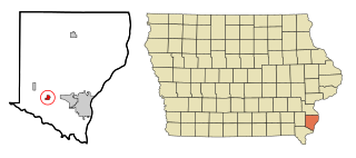
Middletown is a city in Des Moines County, Iowa, United States. The population was 363 at the time of the 2020 census. It is part of the Burlington, IA–IL Micropolitan Statistical Area.

<span class="mw-page-title-main">Rock Valley, Iowa</span> City in Iowa, United States

Rock Valley is a city in Sioux County, Iowa, the North Western corner of Iowa, United States, along the Rock River. The population was 4,059 at the time of the 2020 census.

<span class="mw-page-title-main">Lakewood Club, Michigan</span> Village in Michigan, United States

Lakewood Club is a village in Dalton Township of Muskegon County in the U.S. state of Michigan. The population was 1,291 at the 2010 census.

<span class="mw-page-title-main">Ramsey, Minnesota</span> City in Minnesota, United States

Ramsey is a suburb 22 miles (35 km) north-northwest of downtown Minneapolis in Anoka County, Minnesota, United States. The population was 23,668 at the 2010 census. It is a northwest suburb of the Twin Cities.

<span class="mw-page-title-main">Spring Valley, Minnesota</span> City in Minnesota, United States

Spring Valley is a city in Fillmore County, Minnesota, United States. The population was 2,479 at the 2010 census.

<span class="mw-page-title-main">Coleraine, Minnesota</span> City in Minnesota, United States

Coleraine is a city in Itasca County, Minnesota, United States. The population was 1,970 at the 2010 census. The community was named after Thomas F. Cole, President of the Oliver Iron Mining Company.

<span class="mw-page-title-main">Cleveland, Minnesota</span> City in Minnesota, United States

Cleveland is a city in Le Sueur County, Minnesota, United States. The population was 719 at the 2010 census and 747 at the 2020 census.

<span class="mw-page-title-main">Watkins, Minnesota</span> City in Minnesota, United States

Watkins is a city in Meeker County, Minnesota, United States. The population was 962 at the 2010 census.

<span class="mw-page-title-main">Courtland, Minnesota</span> City in Minnesota, United States

Courtland is a city in Nicollet County, Minnesota, United States. The population was 734 at the 2020 census. It is part of the Mankato-North Mankato Metropolitan Statistical Area.

<span class="mw-page-title-main">Bluffton, Minnesota</span> City in Minnesota, United States

Bluffton is a city in Otter Tail County, Minnesota, United States, along the Leaf River. The population was 210 at the 2020 census.

<span class="mw-page-title-main">Winger, Minnesota</span> City in Minnesota, United States

Winger is a city in Polk County, Minnesota, United States. It is part of the Grand Forks, ND-MN Metropolitan Statistical Area. The population was 174 at the 2020 census.

<span class="mw-page-title-main">Lakeland, Minnesota</span> City in Minnesota, United States

Lakeland is a city in Washington County, Minnesota, United States. The population was 1,796 at the 2010 census.

<span class="mw-page-title-main">Deepwater, Missouri</span> City in Missouri, United States

Deepwater is a city in Henry County, Missouri, United States. The population was 433 at the 2010 census.

<span class="mw-page-title-main">Gastonville, Pennsylvania</span> Census-designated place in Pennsylvania, United States

Gastonville is a census-designated place (CDP) in Washington County, Pennsylvania, United States. The population was 2,818 at the 2010 census.

<span class="mw-page-title-main">Minnesota Lake, Minnesota</span> City in Minnesota, United States

Minnesota Lake is a city in Blue Earth and Faribault counties in the State of Minnesota. The population was 661 at the 2020 census. The bulk of the city is in Faribault County; a small part extends into Blue Earth County.

<span class="mw-page-title-main">Eden Valley, Minnesota</span> City in Minnesota, United States

Eden Valley is a city in Meeker and Stearns counties in the U.S. state of Minnesota. The population was 1,042 at the 2010 census. Most of Eden Valley is in Meeker County; the Stearns County portion is part of the St. Cloud Metropolitan Statistical Area.

<span class="mw-page-title-main">Brooten, Minnesota</span> City in Minnesota, United States

Brooten is a city in Stearns and Pope counties in the U.S. state of Minnesota, United States. The population was 626 as of the 2020 census. Almost the entire city is within Stearns County, with a small portion in Pope County.

<span class="mw-page-title-main">Almond, Wisconsin</span> Village in Wisconsin, United States

Almond is a village in Portage County, Wisconsin, United States. The population was 448 at the 2010 census.

References

  1. "2020 U.S. Gazetteer Files". United States Census Bureau. Retrieved July 24, 2022.
  2. 1 2 3 "Explore Census Data". United States Census Bureau . Retrieved April 20, 2022.
  3. 1 2 "City and Town Population Totals: 2020-2021". United States Census Bureau. June 19, 2022. Retrieved June 19, 2022.
  4. "US Board on Geographic Names". United States Geological Survey. October 25, 2007. Retrieved January 31, 2008.
  5. "Agassiz Recreational Trail (Minnesota)". American Trails. Archived from the original on March 14, 2011. Retrieved March 2, 2011.
  6. "Norman County". Jim Forte Postal History. Retrieved July 26, 2015.
  7. Upham, Warren (1920). Minnesota Geographic Names: Their Origin and Historic Significance. Minnesota Historical Society. p.  384.
  8. "US Gazetteer files 2010". United States Census Bureau. Archived from the original on February 20, 2011. Retrieved November 13, 2012.
  9. United States Census Bureau. "Census of Population and Housing" . Retrieved September 11, 2013.

Coordinates: 47°15′37″N96°15′32″W / 47.26028°N 96.25889°W / 47.26028; -96.25889