Borup, Minnesota

Last updated

Borup
Norman County Minnesota Incorporated and Unincorporated areas Borup Highlighted.svg
Location of Borup, Minnesota
Coordinates: 47°10′50″N96°30′18″W / 47.18056°N 96.50500°W / 47.18056; -96.50500
CountryUnited States
State Minnesota
County Norman
Area
[1]
  Total0.25 sq mi (0.66 km2)
  Land0.25 sq mi (0.66 km2)
  Water0.00 sq mi (0.00 km2)
Elevation
906 ft (276 m)
Population
 (2020) [2]
  Total96
  Estimate 
(2021) [3]
95
  Density377.95/sq mi (146.08/km2)
Time zone UTC-6 (CST)
  Summer (DST) UTC-5 (CDT)
ZIP code
56519
Area code 218
FIPS code 27-07030
GNIS feature ID0640389 [4]

Borup is a city in Norman County, Minnesota, United States. The population was 96 at the 2020 census. [2]

Contents

History

The city was named for Charles William Wulff Borup, a Minnesota banker. [5] A post office called Borup has been in operation since 1896. [6]

The Borup post office. Borup, Minnesota post office.jpg
The Borup post office.

Geography

According to the United States Census Bureau, the city has a total area of 0.25 square miles (0.65 km2), all land. [7]

Minnesota State Highway 9 serves as a main route in the community.

Demographics

Historical population
CensusPop.Note
1960 145
1970 128−11.7%
1980 16025.0%
1990 119−25.6%
2000 91−23.5%
2010 11020.9%
2020 96−12.7%
2021 (est.)95 [3] −1.0%
U.S. Decennial Census [8]
2020 Census [2]

2010 census

As of the census of 2010, there were 110 people, 37 households, and 27 families living in the city. The population density was 440.0 inhabitants per square mile (169.9/km2). There were 51 housing units at an average density of 204.0 per square mile (78.8/km2). The racial makeup of the city was 97.3% White, 1.8% Native American, and 0.9% from two or more races. Hispanic or Latino of any race were 5.5% of the population.

There were 37 households, of which 40.5% had children under the age of 18 living with them, 62.2% were married couples living together, 10.8% had a female householder with no husband present, and 27.0% were non-families. 21.6% of all households were made up of individuals, and 8.1% had someone living alone who was 65 years of age or older. The average household size was 2.97 and the average family size was 3.63.

The median age in the city was 28.8 years. 37.3% of residents were under the age of 18; 7.2% were between the ages of 18 and 24; 20.9% were from 25 to 44; 21.8% were from 45 to 64; and 12.7% were 65 years of age or older. The gender makeup of the city was 52.7% male and 47.3% female.

2000 census

As of the census of 2000, there were 91 people, 38 households, and 22 families living in the city. The population density was 372.7 inhabitants per square mile (143.9/km2). There were 50 housing units at an average density of 204.8 per square mile (79.1/km2). The racial makeup of the city was 86.81% White, 2.20% Native American, 2.20% Asian, and 8.79% from two or more races.

There were 38 households, out of which 28.9% had children under the age of 18 living with them, 57.9% were married couples living together, 2.6% had a female householder with no husband present, and 39.5% were non-families. 39.5% of all households were made up of individuals, and 10.5% had someone living alone who was 65 years of age or older. The average household size was 2.39 and the average family size was 3.26.

In the city, the population was spread out, with 27.5% under the age of 18, 9.9% from 18 to 24, 26.4% from 25 to 44, 20.9% from 45 to 64, and 15.4% who were 65 years of age or older. The median age was 36 years. For every 100 females, there were 116.7 males. For every 100 females age 18 and over, there were 135.7 males.

The median income for a household in the city was $41,042, and the median income for a family was $41,875. Males had a median income of $32,083 versus $22,083 for females. The per capita income for the city was $17,081. None of the population or the families were below the poverty line.

Related Research Articles

<span class="mw-page-title-main">Bluewater, California</span> Census-designated place in California, United States

Bluewater is a census-designated place (CDP) in San Bernardino County, California, United States. The population was 172 at the 2010 census, down from 265 at the 2000 census.

<span class="mw-page-title-main">Galva, Iowa</span> City in Iowa, United States

Galva is a city in Ida County, Iowa, United States. The population was 435 at the time of the 2020 census.

<span class="mw-page-title-main">Chickamaw Beach, Minnesota</span> City in Minnesota, United States

Chickamaw Beach is a city in Cass County, Minnesota, United States. The population was 114 at the 2010 census. It is part of the Brainerd Micropolitan Statistical Area.

<span class="mw-page-title-main">Emily, Minnesota</span> City in Minnesota, United States

Emily is a city in Crow Wing County, Minnesota, United States. The population was 813 at the 2010 census. It is part of the Brainerd Micropolitan Statistical Area.

<span class="mw-page-title-main">Coleraine, Minnesota</span> City in Minnesota, United States

Coleraine is a city in Itasca County, Minnesota, United States. The population was 1,970 at the 2010 census. The community was named after Thomas F. Cole, President of the Oliver Iron Mining Company.

<span class="mw-page-title-main">Lake Bronson, Minnesota</span> City in Minnesota, United States

Lake Bronson is a city in Kittson County, Minnesota, United States. The population was 178 at the 2020 census. Lake Bronson State Park is nearby.

<span class="mw-page-title-main">Ada, Minnesota</span> City in Minnesota, United States

Ada is a city in Norman County, Minnesota, United States. The population was 1,740 at the 2020 census. It is the county seat.

<span class="mw-page-title-main">Deer Creek, Minnesota</span> City in Minnesota, United States

Deer Creek is a city in Otter Tail County, Minnesota, United States. The population was 330 at the 2020 census.

<span class="mw-page-title-main">Elizabeth, Minnesota</span> City in Minnesota, United States

Elizabeth is a city in Otter Tail County, Minnesota, United States. The population was 168 at the 2020 census.

<span class="mw-page-title-main">Henning, Minnesota</span> City in Minnesota, United States

Henning is a city in Otter Tail County, Minnesota, United States. The population was 854 at the 2020 census.

<span class="mw-page-title-main">Ottertail, Minnesota</span> City in Minnesota, United States

Ottertail is a city in Otter Tail County, Minnesota, United States. The population was 629 at the 2020 census.

<span class="mw-page-title-main">Minnesota City, Minnesota</span> City in Minnesota, United States

Minnesota City is a city in Winona County, Minnesota, United States. The population was 202 at the 2020 census.

<span class="mw-page-title-main">Sibley, Missouri</span> Village in Missouri, United States

Sibley is a village in Jackson County, Missouri, United States. The population was 314 at the 2020 census. It is known as the home of Fort Osage National Historic Landmark. It is part of the Kansas City metropolitan area.

<span class="mw-page-title-main">Fifty Lakes, Minnesota</span> City in Minnesota, United States

Fifty Lakes is a city in Crow Wing County, Minnesota, United States. The population was 387 at the 2010 census. It is part of the Brainerd Micropolitan Statistical Area.

Short is a census-designated place (CDP) in Sequoyah County, Oklahoma, United States. It is part of the Fort Smith, Arkansas-Oklahoma Metropolitan Statistical Area. The population was 328 at the 2000 census.

<span class="mw-page-title-main">Le Raysville, Pennsylvania</span> Borough in Pennsylvania, United States

Le Raysville is a borough in Bradford County, Pennsylvania, United States. It is part of Northeastern Pennsylvania. The population was 290 at the 2020 census.

<span class="mw-page-title-main">Atlantic, Pennsylvania</span> Census-designated place in Pennsylvania, United States

Atlantic is a census-designated place (CDP) in Crawford County, Pennsylvania, United States. The population was 77 at the 2010 census, up from 43 in 2000.

<span class="mw-page-title-main">Plumville, Pennsylvania</span> Borough in Pennsylvania, United States

Plumville is a borough in Indiana County, Pennsylvania, United States. The population was 257 at the 2020 census.

<span class="mw-page-title-main">Dumbarton, Virginia</span> Census-designated place in Virginia

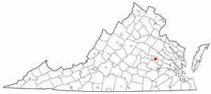
Dumbarton is a census-designated place (CDP) in Henrico County, Virginia, United States. The population was 7,879 at the 2010 census.

<span class="mw-page-title-main">Minnesota Lake, Minnesota</span> City in Minnesota, United States

Minnesota Lake is a city in Blue Earth and Faribault counties in the State of Minnesota. The population was 661 at the 2020 census. The bulk of the city is in Faribault County; a small part extends into Blue Earth County.

References

  1. "2020 U.S. Gazetteer Files". United States Census Bureau. Retrieved July 24, 2022.
  2. 1 2 3 "Explore Census Data". United States Census Bureau . Retrieved April 20, 2022.
  3. 1 2 "City and Town Population Totals: 2020-2021". United States Census Bureau. June 19, 2022. Retrieved June 19, 2022.
  4. "US Board on Geographic Names". United States Geological Survey. October 25, 2007. Retrieved January 31, 2008.
  5. Upham, Warren (1920). Minnesota Geographic Names: Their Origin and Historic Significance. Minnesota Historical Society. p.  382.
  6. "Norman County". Jim Forte Postal History. Retrieved July 26, 2015.
  7. "US Gazetteer files 2010". United States Census Bureau. Archived from the original on January 25, 2012. Retrieved November 13, 2012.
  8. United States Census Bureau. "Census of Population and Housing" . Retrieved February 12, 2014.

47°10′49″N96°30′22″W / 47.18028°N 96.50611°W / 47.18028; -96.50611