
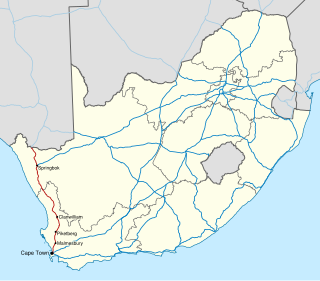
Cape Town is the legislative capital of South Africa. It is the country's oldest city and the seat of the Parliament of South Africa. It is the country's second-largest city, after Johannesburg, and the largest in the Western Cape. The city is part of the City of Cape Town metropolitan municipality.
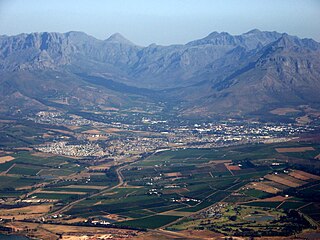
Stellenbosch is a town in the Western Cape province of South Africa, situated about 50 kilometres east of Cape Town, along the banks of the Eerste River at the foot of the Stellenbosch Mountain. The town became known as the City of Oaks or Eikestad in Afrikaans and Dutch due to the large number of oak trees that were planted by its founder, Simon van der Stel, to grace the streets and homesteads.

Bellville is a town and former independent city that is now incorporated into the City of Cape Town Metropolitan Municipality in the Western Cape province of South Africa. The town is an industrial and commercial node, a university town, and a major transportation hub within the Greater Cape Town metropolis.
Swartland Municipality is a local municipality located in the Western Cape province of South Africa. Malmesbury is the seat of the municipality. As of 2016, it had a population of 133,762. Its municipality code is WC015.

The R45 is a provincial route in Western Cape, South Africa that connects Saldanha with Villiersdorp via Vredenburg, Malmesbury and Paarl. The route is mostly a two-lane wide-shouldered highway, however sections within Paarl and between Vredenburg and Saldanha are dual-carriageways. The R45 is co-signed with the N7 for a short segment north of Malmesbury.
The R302 is a Regional Route in South Africa that connects Bellville with Malmesbury. It covers a distance of 54 kilometres (34 mi) in a north-south direction.

Kuils River is a town in the Western Cape, South Africa, 25 km east of Cape Town CBD at the gateway of the Cape Winelands. It is also the name of the main tributary of the Eerste River, and forms part of the Eastern Suburbs of the City of Cape Town.

Kraaifontein is a town in the Western Cape province of South Africa and is located on the north-eastern outskirts of the City of Cape Town Metropolitan Municipality.
The N7 is a national route in South Africa that runs from Cape Town northwards through the West Coast and Namaqualand regions to the Namibian border at Vioolsdrif. After crossing the border, it changes designation to B1 and runs north through Windhoek and the north of Namibia.

Brackenfell is a railway town in the Western Cape province of South Africa and a northern suburb of Cape Town, situated about 30 km north-east of the city. Regarded as the gateway to the Cape Winelands, Brackenfell is situated approximately 22 km north-west of Stellenbosch and 35 km south-west of Paarl and lies at the start of the Bottelary Hills Wine Route which follows the scenic and winding Bottelary Road towards Stellenbosch.

Durbanville is a town in the Western Cape province of South Africa, part of the greater Cape Town metropolitan area. Durbanville is a semi-rural residential suburb on the north-eastern outskirts of the metropolis surrounded by farms producing wine and wheat.

Milnerton is a seaside town on Table Bay and is located north of Cape Town in South Africa. It is located 11 kilometres to the north of the city's centre.

The Cape Fold Belt is a fold and thrust belt of late Paleozoic age, which affected the sequence of sedimentary rock layers of the Cape Supergroup in the southwestern corner of South Africa. It was originally continuous with the Ventana Mountains near Bahía Blanca in Argentina, the Pensacola Mountains, the Ellsworth Mountains and the Hunter-Bowen orogeny in eastern Australia. The rocks involved are generally sandstones and shales, with the shales persisting in the valley floors while the erosion resistant sandstones form the parallel ranges, the Cape Fold Mountains, which reach a maximum height of 2325 m at Seweweekspoortpiek.
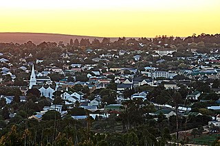
Malmesbury is a town of approximately 36,000 inhabitants in the Western Cape province of South Africa, about 65 km north of Cape Town.

Metrorail Western Cape is a network of commuter and suburban rail services in the City of Cape Town Metropolitan Municipality and in the surrounding towns of Malmesbury, Paarl, Stellenbosch and Wellington in the Western Cape province of South Africa.

Table Mountain Sandstone (TMS) is a group of rock formations within the Cape Supergroup sequence of rocks. Although the term "Table Mountain Sandstone" is still widely used in common parlance, the term TMS is no longer formally recognized; the correct name is the "Peninsula Formation Sandstone", which is part of the Table Mountain Group. The designation "Table Mountain Sandstone" will, however, in deference to the title, continue to be used in the rest of this article. The name is derived from the famous landmark in Cape Town, Table Mountain.

Hopefield is a settlement in West Coast District Municipality in the Western Cape province of South Africa on the R45 between Malmesbury and Vredenburg. The town is east of Saldanha Bay and Langebaan, 40 km (25 mi) southeast of Vredenburg and 120 km (75 mi) north of Cape Town.
Klipheuwel is a village of about 2,300 people situated 15 kilometres (9.3 mi) north of Durbanville, in the Western Cape province of South Africa. In the 1920s it was the site of a shortwave transmitter constructed by the Marconi Company as part of the Imperial Wireless Chain. It remains today the site of the transmitter for the Cape Talk AM radio station.
Richwood is an outer northern suburb of Cape Town, South Africa and is about 15 kilometres (9.3 mi) north-east of the city alongside the N7 freeway. According to the 2011 census it has a population of 2,988 residents in 963 households, although it has significantly expanded in recent years. The name is a portmanteau of "Richmond Park" and "Goodwood".

The Northern Suburbs is a major urban and rural region located in the City of Cape Town Metropolitan Municipality in the Western Cape province of South Africa. It is the urban north-eastern part of the Greater Cape Town metropolitan area that is functionally merged with Cape Town.


