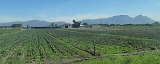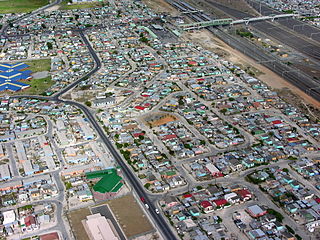
The Cape Flats is an expansive, low-lying, flat area situated to the southeast of the central business district of Cape Town. The Cape Flats is also the name of an administrative region of the City of Cape Town, which lies within the larger geographical area.

Samora Moisés Machel was a Mozambican military commander and political leader. A socialist in the tradition of Marxism–Leninism, he served as the first President of Mozambique from the country's independence in 1975. Machel died in office in 1986 when his presidential aircraft crashed near the Mozambican-South African border.

Dame Graça Machel is a Mozambican politician and humanitarian. She is the widow of former President of Mozambique Samora Machel (1975–1986) and former President of South Africa Nelson Mandela (1998–2013). Machel is an international advocate for women's and children's rights and was made an honorary British Dame by Queen Elizabeth II in 1997 for her humanitarian work. She is the only woman in modern history to have served as First Lady of two countries, South Africa and Mozambique.
The following lists events that happened during 1987 in South Africa.

Langa is a township in Cape Town, South Africa. Its name in Xhosa means "sun". The township was initially built in phases before being formally opened in 1927. It was developed as a result of South Africa's 1923 Urban Areas Act, which was designed to force Africans to move from their homes into segregated locations. Similar to Nyanga, Langa is one of the many areas in South Africa that were designated for Black Africans before the apartheid era. It is the oldest of such suburbs in Cape Town and was the location of much resistance to apartheid.

Gugulethu is a township in the Western Cape, South Africa and is 15 km from Cape Town. Its name is a contraction of igugu lethu, which is Xhosa for our pride. The township was established along with Nyanga in the 1960s.

Mitchells Plain is a large township located within the City of Cape Town, Western Cape, South Africa and situated about 28 km (17 mi) from the Cape Town city centre. It is one of South Africa's largest residential areas and contains multiple smaller suburbs. It is located on the Cape Flats on the False Bay coast between Muizenberg and Khayelitsha. Conceived of as a "model suburb" by the apartheid government, it was built during the 1970s to provide housing for Coloured victims of forced removal due to the implementation of the Group Areas Act.

The Mineral Revolution is a term used by historians to refer to the rapid industrialisation and economic changes which occurred in South Africa from the 1860s onwards. The Mineral Revolution was largely driven by the need to create a permanent workforce to work in the mining industry, and saw South Africa transformed from a patchwork of agrarian states to a unified, industrial nation. In political terms, the Mineral Revolution had a significant impact on diplomacy and military affairs. Finally, the policies and events of the Mineral Revolution had an increasingly negative impact on race relations in South Africa, and formed the basis of the apartheid system, which dominated South African society for a century. The Mineral Revolution was caused by the discovery of diamonds in Kimberly in 1867 and also by the discovery of gold in Witwatersrand in 1886. The mineral mining revolution laid the foundations of racial segregation and the control of white South Africans over black South Africans. The Mineral Revolution changed South Africa from being an agricultural society to becoming the largest gold producing country in the world.

Nyanga is a township in the Western Cape, South Africa. Its name in Xhosa means "moon" and it is one of the oldest black townships in Cape Town. It was established as a result of the migrant labour system. In 1948 black migrants were forced to settle in Nyanga as Langa had become too small. Nyanga was one of the poorest places in Cape Town and is still is one of the most dangerous parts of Cape Town. In 2001 its unemployment rate was estimated at being approximately 56% and HIV/AIDS is a huge community issue.
Lwandle/Nomzamo is a small township in the Helderberg basin just outside Strand in the Western Cape of South Africa. Both names are sometimes used interchangeably referring to both places. This may be attributed to the fact that Nomzamo was born as a result of overpopulation in Lwandle area which initially designed as a cheap accommodation for "single male workers" during the apartheid years.

Crossroads is a high-density township in the Western Cape, South Africa.

Horticulture is the science and art of growing fruits and vegetables and also flowers or ornamental plants.

Manenberg is a township of Cape Town, South Africa, that was created by the apartheid government for low-income Coloured families in the Cape Flats in 1966 as a result of the forced removal campaign by the National Party. It has an estimated population of 52,000 residents. The area consists of rows of semi-detached houses and project-like flats, known as "korre". The township is located about 20 km away from the city centre of Cape Town. It is separated from neighbouring Nyanga and Gugulethu townships by a railway line to the east and from Hanover Park by the Sand Industria industrial park to the west and Heideveld to the north. The northern part of Manenberg has wealthy people that are mostly Muslims. The rest of Manenberg has poor people that are mostly associated with Christianity.

The Western Cape Anti-Eviction Campaign was a non-racial popular movement made up of poor and oppressed communities in Cape Town, South Africa. It was formed in November 2000 with the aim of fighting evictions, water cut-offs and poor health services, obtaining free electricity, securing decent housing, and opposing police brutality.
Prior to 1994, immigrants from elsewhere faced discrimination and even violence in South Africa. After majority rule in 1994, contrary to expectations, the incidence of xenophobia increased. Between 2000 and March 2008, at least 67 people died in what were identified as xenophobic attacks. In May 2008, a series of attacks left 62 people dead; although 21 of those killed were South African citizens. The attacks were motivated by xenophobia. In 2015, another nationwide spike in xenophobic attacks against immigrants in general prompted a number of foreign governments to begin repatriating their citizens. A Pew Research poll conducted in 2018 showed that 62% of South Africans viewed immigrants as a burden on society by taking jobs and social benefits and that 61% of South Africans thought that immigrants were more responsible for crime than other groups. Between 2010 and 2017 the immigrant community in South Africa increased from 2 million people to 4 million people. The proportion of South Africa's total population that is foreign born increased from 2.8% in 2005 to 7% in 2019, according to the United Nations International Organization for Migration, in spite of widespread xenophobia in the country. This made South Africa the largest recipient of immigrants on the African continent in 2019.

Hanover Park is a neighborhood of the City of Cape Town in the Western Cape province of South Africa.
Fezeka High School is a public high school located in Gugulethu, Western Cape, South Africa. It is one of the high schools in the City of Cape Town Metropolitan Municipality.

The Philippi Horticultural area is a large semi-urban semi-rural area of Philippi in Cape Town's Cape Flats region, in the Western Cape province of South Africa. The horticultural area is sparsely populated compared to the surrounding city and contains many farms. The 2011 national census recorded 6,618 residents living in the area with an additional 2,961 residents living in the Knole Park community in the central western part of the area.

The Brown's Farm area is a neighborhood located within the Philippi area of Cape Town's Cape Flats region, in the Western Cape province of South Africa. The urban area is densely populated and contains many informal homes. The 2011 national census recorded 71,518 residents living in the area.


