
The Yarra River or historically, the Yarra Yarra River, is a perennial river in south-central Victoria, Australia.

Docklands, is an inner-city suburb in Melbourne, Victoria, Australia on the western end of the central business district. Docklands had a population of 15,495 at the 2021 census.

Maribyrnong is an inner-city suburb in Melbourne, Victoria, Australia, 8 km (5.0 mi) north-west of Melbourne's Central Business District, located within the City of Maribyrnong local government area. Maribyrnong recorded a population of 12,573 at the 2021 census.

The Maribyrnong River is a perennial river of the Port Phillip catchment, located in the north–western suburbs of Melbourne, in the Australian state of Victoria.

Essendon is an Inner suburb in Melbourne, Victoria, Australia, 8 km (5.0 mi) north-west of Melbourne's central business district, located within the City of Moonee Valley local government area. Essendon recorded a population of 21,240 at the 2021 census.

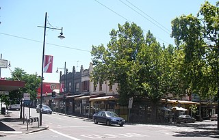
Footscray is an inner-city suburb in Melbourne, Victoria, Australia, 5 km (3.1 mi) west of Melbourne's Central Business District, located within the City of Maribyrnong local government area and its council seat. Footscray recorded a population of 17,131 at the 2021 census.

Elizabeth Street is one of the main streets in the Melbourne central business district, Victoria, Australia, part of the Hoddle Grid laid out in 1837. It is presumed to have been named in honour of governor Richard Bourke's wife.

Yarraville is an inner suburb in Melbourne, Victoria, Australia, 7 km (4.3 mi) west of Melbourne's Central Business District, located within the City of Maribyrnong local government area. Yarraville recorded a population of 15,636 at the 2021 census.

Melbourne tram route 57 is operated by Yarra Trams on the Melbourne tram network from West Maribyrnong to Flinders Street station. The 11.6 kilometre route is operated out of Essendon depot with Z class trams.

The Maribyrnong River Trail is a shared use path for cyclists and pedestrians, which follows the Maribyrnong River through the north western suburbs of Melbourne, Victoria, Australia.

Essendon West is a suburb in Melbourne, Victoria, Australia, 10 km (6.2 mi) north-west of Melbourne's Central Business District, located within the City of Moonee Valley local government area. Essendon West recorded a population of 1,559 at the 2021 census.
Kensington is an inner-city suburb in Melbourne, Victoria, Australia, 4 km (2.5 mi) north-west of Melbourne's Central Business District, located within the City of Melbourne local government area. Kensington recorded a population of 10,745 at the 2021 census.
Avondale Heights is a suburb in Melbourne, Victoria, Australia, 11 km (6.8 mi) north-west of Melbourne's Central Business District, located within the City of Moonee Valley local government area. Avondale Heights recorded a population of 12,388 at the 2021 census.

Brimbank Park is a metropolitan regional park managed by Parks Victoria situated in the north-western Melbourne suburb of Keilor East, Victoria, Australia.

Melbourne is Australia's second largest city and widely considered to be a garden city, with Victoria being nicknamed "the Garden State". Renowned as one of the most livable cities in the world, there is an abundance of parks, gardens and green belts close to the CBD with a variety of common and rare plant species amid landscaped vistas, pedestrian pathways, and tree-lined avenues, all managed by Parks Victoria.

Highpoint Shopping Centre is a shopping centre located in Maribyrnong, in the western suburbs of Melbourne, Victoria, Australia.
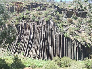
The Organ Pipes National Park, abbreviated as OPNP, is a national park located in the Central region of Victoria, Australia. The 121-hectare (300-acre) protected area was established with the focus on conservation of the native flora and fauna, and preservation of the geological features in the Jacksons Creek, a part of the Maribyrnong valley, north-west of Melbourne. It is situated in a deep gorge in the grassy, basalt Keilor Plains.

Melbourne's Living Museum of the West is an ecomuseum and community social history museum in Melbourne's western suburb of Maribyrnong. It was established as part of Victoria's sesquicentenary in 1984, along with the Children's Museum and the Museum of Chinese Australian History.
MREAM, or Maribyrnong River Edge Art Movement was a community arts organisation in Melbourne, Australia.
Albert Purchas was a prominent 19th century architect and surveyor in Melbourne, Australia.

