Parks and gardens of Melbourne

Last updated

The skyline visible from the Royal Botanic Gardens Skyline 2 Melbourne.JPG
The skyline visible from the Royal Botanic Gardens
An avenue of English Elms in Fitzroy Gardens English Elm avenue.jpg
An avenue of English Elms in Fitzroy Gardens
View of the city centre from the Shrine of Remembrance Melbourne from the Shrine of Remembrance.jpg
View of the city centre from the Shrine of Remembrance

Melbourne is Australia's second largest city and widely considered to be a garden city, with Victoria being nicknamed "the Garden State". [1] [2] Renowned as one of the most livable cities in the world, there is an abundance of parks, gardens and green belts close to the CBD with a variety of common and rare plant species amid landscaped vistas, pedestrian pathways, and tree-lined avenues, all managed by Parks Victoria.

Contents

The first superintendent of the Port Phillip region, Charles La Trobe, set aside large tracts of land around the city for open space, parkland and gardens. Much of this land has since been excised for public infrastructure like sporting complexes, railways, hospitals and other public buildings, and also for residential development, but a substantial amount has remained. This allowed landscape designer Clement Hodgkinson and Director of the Royal Botanic Gardens, Melbourne, William Guilfoyle, to landscape many of the parks and gardens. Many of these parks and gardens are within easy walking distance of the central business district.

Inner suburbs

Carlton Gardens south Carlton gardens.jpg
Carlton Gardens south
Late afternoon sunlight on the Fitzroy Gardens Fitzroy Gardens.jpg
Late afternoon sunlight on the Fitzroy Gardens
Speaker's mound at Speakers' corner, Birrarung Marr Birrarung Marr Speakers Corner.jpg
Speaker's mound at Speakers' corner, Birrarung Marr
Catani Gardens in St Kilda is typical of the many gardens in the bayside area which are often lined with stands of Canary Island Date Palms. Catani gardens st kilda.jpg
Catani Gardens in St Kilda is typical of the many gardens in the bayside area which are often lined with stands of Canary Island Date Palms.
Aerial panorama of the Victoria State Rose Garden in Werribee Victoria State Rose Garden in Werribee.jpg
Aerial panorama of the Victoria State Rose Garden in Werribee

Other parks of note in the inner suburbs include Edinburgh Gardens (c. 24 ha) in Fitzroy North, Fawkner Park (41 ha), Como Park and Victoria Gardens in South Yarra, Alma Park and the St Kilda Botanical Gardens in St Kilda, Hedgeley Dene Gardens and Central Park in Malvern, Princes Park in Caulfield, and Footscray Park in Footscray, and Hays Paddock in Kew East.

Outer suburbs

Maribyrnong River at Brimbank Park Brimbank Park.jpg
Maribyrnong River at Brimbank Park
Aerial panorama of Ruffey Lake Park. Sunset 24 September 2023. Aerial panorama of Ruffey Lake Park. Sunset 24 September 2023.jpg
Aerial panorama of Ruffey Lake Park. Sunset 24 September 2023.

While most attention is paid to parks and gardens in the inner urban area around the CBD, extensive and significant parks and rivers can also be found around the outer suburbs of Melbourne. These include:

Other suburban rivers/creeks with fantastic trails and reserves and within 20 km of the CBD include Merri Creek, Moonee Ponds Creek, Kororoit Creek, Plenty River, Darebin Creek and Eumemmerring Creek.

Dandenong Ranges

The Dandenong Ranges to the east of Melbourne are famous for their gardens, which are established on rich volcanic soil in a high rainfall area. A popular pastime during autumn is to drive through the hills viewing the vibrant foliage of deciduous trees. Some public gardens in the Ranges include:

Private gardens

Residential gardening is a popular pastime throughout Melbourne, and the city is known for its leafy green suburbs. Many private gardens open for public viewing through Australia's Open Garden Scheme, which started in Melbourne.

See also

Treasury Gardens in Winter Melbourne Treasury Gardens.jpg
Treasury Gardens in Winter

Related Research Articles

Victoria is the smallest mainland state in Australia. As of 2022 it contained 5,081 separate protected areas with a total land area of 4,012,888 ha.

<span class="mw-page-title-main">Yarra River</span> River in Victoria, Australia

The Yarra River or historically, the Yarra Yarra River, is a perennial river in south-central Victoria, Australia.

<span class="mw-page-title-main">Maribyrnong, Victoria</span> Suburb of Melbourne, Victoria, Australia

Maribyrnong is an inner-city suburb in Melbourne, Victoria, Australia, 8 km (5.0 mi) north-west of Melbourne's Central Business District, located within the City of Maribyrnong local government area. Maribyrnong recorded a population of 12,573 at the 2021 census.

<span class="mw-page-title-main">Maribyrnong River</span> River in Melbourne, Victoria, Australia

The Maribyrnong River is a perennial river of the Port Phillip catchment, located in the north–western suburbs of Melbourne, in the Australian state of Victoria.

<span class="mw-page-title-main">Olinda, Victoria</span> Suburb of Melbourne, Victoria, Australia

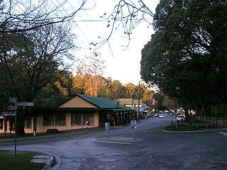
Olinda is a town within the Dandenong Ranges in central-south Victoria, Australia, located 41 km (25 mi) east of Melbourne's CBD, located within the Shire of Yarra Ranges local government area. Olinda recorded a population of 1,773 at the 2021 census.

<span class="mw-page-title-main">Sassafras, Victoria</span> Town in Victoria, Australia

Sassafras is a locality and township within Greater Melbourne, beyond the Melbourne metropolitan area Urban Growth Boundary, 43 km east of Melbourne's Central Business District, located within the City of Knox and Shire of Yarra Ranges local government areas. Sassafras recorded a population of 970 at the 2021 census.

<span class="mw-page-title-main">Alphington, Victoria</span> Suburb of Melbourne, Victoria, Australia

Alphington is a suburb in Melbourne, Victoria, Australia, 7 km (4.3 mi) north-east of Melbourne's Central Business District, located within the Cities of Darebin and Yarra local government areas. Alphington recorded a population of 5,702 at the 2021 census.

<span class="mw-page-title-main">Yarraville, Victoria</span> Suburb of Melbourne, Victoria, Australia

Yarraville is an inner-city suburb in Melbourne, Victoria, Australia, 6 km (3.7 mi) west of Melbourne's Central Business District, located within the City of Maribyrnong local government area. Yarraville recorded a population of 15,636 at the 2021 census.

<span class="mw-page-title-main">Royal Botanic Gardens Victoria</span> Botanic gardens at Melbourne and Cranbourne

Royal Botanic Gardens Victoria are botanic gardens across two sites–Melbourne and Cranbourne.

<span class="mw-page-title-main">Maribyrnong River Trail</span>

The Maribyrnong River Trail is a shared use path for cyclists and pedestrians, which follows the Maribyrnong River through the north western suburbs of Melbourne, Victoria, Australia.

<span class="mw-page-title-main">West Melbourne, Victoria</span> Suburb of Melbourne, Victoria, Australia

West Melbourne is an inner-city suburb in Melbourne, Victoria, Australia, 2 km (1.2 mi) north-west of the Melbourne central business district, located within the City of Melbourne local government area. West Melbourne recorded a population of 8,025 at the 2021 census.

<span class="mw-page-title-main">Royal Park, Melbourne</span> Urban park in Melbourne, Australia

Royal Park is the largest of Melbourne's inner city parks. It is located four kilometres (2.5 mi) north of the Melbourne CBD, in Victoria, Australia, in the suburb of Parkville.

<span class="mw-page-title-main">Alexandra Gardens, Melbourne</span> Public gardens in Melbourne, Australia

The Alexandra Gardens are located on the south bank of the Yarra River, opposite Federation Square and the Melbourne Central Business District, in Victoria, Australia. The Gardens are bounded by the Yarra River to the north, Princes and Swan street bridges, with Queen Victoria Gardens and Kings Domain across Alexandra Avenue to the south. The gardens are part of the Domain parklands which stretch to the Royal Botanic Gardens and were first laid out in 1901, under the direction of Carlo Catani, Chief Engineer of the Public Works Department. The Alexandra Gardens were named in honor of Alexandra of Denmark, in the year her reign as Queen Consort of the United Kingdom and the British Dominions and Empress consort of India began. The Alexandra Gardens are listed on the Victorian Heritage Register due to their historical and archaeological significance.

<span class="mw-page-title-main">Albert Park and Lake</span>

Albert Park is a large public park in the City of Port Phillip, an inner suburban LGA of Melbourne, Victoria, Australia. Located 3 km (1.9 mi) south of the Melbourne central business district, the park encompasses 2.25 km2 of parkland around the 1.8 km (1.1 mi) long Albert Park Lake, a 0.49 km2 Y-shaped artificial lake used both for water sports and public recreation.

<span class="mw-page-title-main">Darebin Creek</span> River in Victoria, Australia

Darebin Creek is a creek that runs through the northern suburbs of Melbourne, Victoria, Australia. It is the main watercourse of the Darebin Valley and a major tributary of the Yarra River. For tens of thousands of years it was used as a food and tool source sustainably by the Wurundjeri people, Indigenous Australians of the Kulin nation alliance, who spoke variations of the Woiwurrung language group.

<span class="mw-page-title-main">Caribbean Gardens</span> Australian retail market

Caribbean Gardens was a 100-acre (40 ha) market, gardens and amusement park located in the outer eastern suburb of Scoresby in Melbourne, Australia, on the north/west side of Caribbean Lake, a large 1.2 km (0.75 mi)-long artificial lake along the northern (right) bank of Corhanwarrabul Creek, a major tributary of Dandenong Creek.

<span class="mw-page-title-main">Lakes and reservoirs of Melbourne</span>

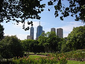
Melbourne is the capital city of southeastern Australian state of Victoria and also the nation's second most populous city, and has been consistently voted one of the most liveable cities in the world. Located on the northern/eastern coastal plains of Port Phillip Bay, the city is the one of the drier capital cities in Australia, but due to its relatively flat terrain and the runoffs fed from surrounding highlands, still has many lakes, ponds and wetlands, mainly managed by Melbourne Water and Parks Victoria. The larger waterbodies are used for water sports, mostly boating but some are used for recreational activities like swimming, water skiing or model boating.

<span class="mw-page-title-main">Geography of Melbourne</span>

Melbourne, the capital city of Victoria, Australia, is situated on the southeastern fringe of the Australian landmass and in the southern central part of the state. Melbourne covers an urbanised area of approximately 2,453 km²–larger than that of Sydney, Greater London and Mexico City, with population density roughly around 16 people per hectare on average.

<span class="mw-page-title-main">Dandenong Valley Parklands</span> Public parks in south east Melbourne, Victoria, Australia

The Dandenong Valley Parklands are a collection of public parks and open space reserves along the Dandenong Creek, an urban creek in southeastern Melbourne, Victoria, Australia. The term refers only to the parklands along and in close proximity to the middle main stem of Dandenong Creek, stretching from Boronia Road in the north to Wellington Road in the south through the suburbs of Vermont South, Wantirna, Wantirna South and Wheelers Hill, even though there are a lot more parks and reserves along the extended catchment of the creek.

References

  1. "Premier of Victoria, Australia – FLOWER AND GARDEN SHOW BLOSSOMS IN 2008". premier.vic.gov.au. Retrieved 10 June 2008.
  2. "Victorian Parliamentary Hansard – Parliament of Victoria". tex2.parliament.vic.gov.au. Retrieved 10 June 2008.

37°48′47.41″S144°57′46.73″E / 37.8131694°S 144.9629806°E / -37.8131694; 144.9629806