Blackburn Lake Sanctuary

Last updated

Blackburn Lake Sanctuary
Blackburn Lake South.PNG
Blackburn Lake, looking south
Blackburn Lake Sanctuary
TypePublic Park
Location Melbourne
Coordinates 37°49′34″S145°09′43″E / 37.826°S 145.162°E / -37.826; 145.162 Coordinates: 37°49′34″S145°09′43″E / 37.826°S 145.162°E / -37.826; 145.162
Area30 ha (74 acres)
Established1889
Operated by City of Whitehorse
StatusOpen
PathsUnsealed bush paths
TerrainBushland, lake
WaterBlackburn Lake, Kooyongkoot Creek
Vegetation Australian native plants, wildflower farm, palm trees
Connecting transportTrain, bus, car [1]
FacilitiesToilets, playground, visitors centre, seating and shelters [1]

Blackburn Lake Sanctuary is an example of regenerated and remnant bushland in suburban Melbourne, Australia. It is located in the suburb of Blackburn. It is the most significant of the many parks in the City of Whitehorse, featuring areas of regenerated bushland and various walking tracks.

Contents

In 1889 the Kooyongkoot Creek was dammed forming Blackburn Lake, at the centre of the sanctuary. The park has a diverse history revolving around the human usage of the lake and surrounding bushland, which by the 1960s left the lake in particular, very polluted. Although still polluted today, the late 20th century saw much regenerative planting and protection measures by local residents and community groups which has halted and in some places reduced pollution. Today, the park is home to a variety of local wildlife, including Pacific black ducks and herons. The sanctuary also features a variety of other birds, as well as possums and sugar gliders.

History

In 1889 the lake itself was formed when Gardiners Creek was dammed to provide water for local fruit growers. The lake grew in popularity as a tourist destination, with visitors from Melbourne travelling two hours by steam train to reach it. During the 1890s, artist Frederick McCubbin of the famed Heidelberg School lived briefly near the lake, where he painted works including "Down on His Luck", "The Bush Burial" and "Bush Idyll".

In 1909 the Adult Deaf Society purchased the land surrounding the lake, where they established a hospice and a flower farm. In 1964 the Society sold the lake and the land around it to the Melbourne Water board, and in 1965 the area was declared a sanctuary. Later public purchases increased the size of the sanctuary until it reached its current size in 1992. The Visitor Centre was refurbished in 1991 to accommodate an expanded education programme.

Much of the history of the park revolves around the damming of Kooyongkoot Creek and its use over time. See below for history of Blackburn Lake.

Geography

Friends Bridge over an arm of Blackburn Lake Friends Bridge Blackburn Lake.PNG
Friends Bridge over an arm of Blackburn Lake

The park sits on around 30 hectares (74 acres) of land in the middle of Blackburn, a suburb of Melbourne, Victoria to which it is located about 18 kilometres (11 mi) east of the central business district of Melbourne.

Blackburn Lake

In the early days before the lake was formed, Kooyongkoot Creek wound its way down the valley from Mitcham to Blackburn on its way to the Yarra River. It would have been joined along the way, particularly in winter, by many little rivulets and streams; some of these gullies can still be seen as you walk around the lake today. In summer, the creek is suspected to have dried up at times.

The lake was dammed in 1889 initially to provide water for local fruit growers, but was later used and misused for various reasons and activities until the late 1970s. Today, activities on the lake are limited to protect the surrounding environment. The lake is fed by a number of small creeks to its east and many small surrounding gullies. The dam wall is located in lake's west reaches, Lake Road runs along the top of this wall. Kooyongkoot Creek heads west from the wall, through the beginnings of its course to the Yarra River.

It was initially about 50 feet (15 m) deep where the creek had been mined for antimony, but recent studies show that it is not that deep today, having silted up over the intervening years. In the 1920s, diving towers were erected and swimming lessons were held at the lake, the water quality was as yet unaffected by surrounding land clearing, agriculture and development. The Blackburn Swimming Club was forced to close in 1931 due to vandalism of the facilities.

During the 1950s and 1960s, the lake became a dumping ground for rubbish, and there are supposed to be old car bodies and other rubbish at the bottom. These would have leached acids, lead and hydrocarbons into the water over the years. Pollution in the lake renders it unusable as a source of water for the surrounding human population or agriculture. In 1962 the dam wall in Lake Rd was built by the MMBW to form a retarding basin to prevent flooding further down Kooyongkoot Creek, and the Lake Rd Bridge was demolished in 1965.

The bridges that cross the lake and its creeks and gullies include: [1]

Recreation

Eucalypts and a gravel pathway in Blackburn Lake Sanctuary near the old flower farm Blackburn Lake Eucalypts.PNG
Eucalypts and a gravel pathway in Blackburn Lake Sanctuary near the old flower farm

Throughout the park's history, much of the recreation in the park revolved around the lake, however today recreation revolves around the appreciation of the Australian native flora, much of which has been regenerated over time. The park is popular with bushwalkers. Cycling is also popular but is usually only partaken locally as the park does not host a cycling through-route trail.

Access information

Gwenda Avenue (Main entrance and carpark)
Fulview Court
Cromwell Court
Jeffery Street
Naughton Grove (dam wall)
Halley Street (dam wall)
Ottawa Avenue
Via Playground

Related Research Articles

<span class="mw-page-title-main">Yarra River</span> River in Victoria, Australia

The Yarra River or historically, the Yarra Yarra River, is a perennial river in south-central Victoria, Australia.

<span class="mw-page-title-main">Belgrave, Victoria</span> Suburb of Melbourne, Victoria, Australia

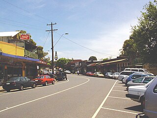
Belgrave is a town and outer suburb in Melbourne, Victoria, Australia, 36 km east of Melbourne's central business district, located within the Shire of Yarra Ranges local government area. Belgrave recorded a population of 3,894 at the 2021 census.

<span class="mw-page-title-main">Upwey, Victoria</span> Suburb of Melbourne, Victoria, Australia

Upwey is a suburb of Melbourne, Victoria, Australia, 33 kilometres (21 mi) east from Melbourne's central business district, located within the City of Knox and the Shire of Yarra Ranges local government areas. Upwey recorded a population of 6,818 at the 2021 census.

<span class="mw-page-title-main">Alphington, Victoria</span> Suburb of Melbourne, Victoria, Australia

Alphington is a suburb in Melbourne, Victoria, Australia, 7 km (4.3 mi) north-east of Melbourne's Central Business District, located within the Cities of Darebin and Yarra local government areas. Alphington recorded a population of 5,702 at the 2021 census.

<span class="mw-page-title-main">Wonga Park, Victoria</span> Town in Victoria, Australia

Wonga Park is a locality on the edge of Greater Melbourne, beyond the Melbourne Metropolitan Urban Growth Boundary area, 28 km north-east from Melbourne's Central Business District, located within the Cities of Manningham and Maroondah and the Shire of Yarra Ranges local government areas. Wonga Park recorded a population of 3,843 at the 2021 census.

Lillydale Lake is an artificial lake and wetlands area created in Lilydale, Melbourne, Australia. The park in which it is situated covers over 100 hectares and includes extensive recreational facilities.

Eildon is a town in Victoria, Australia. It is located near Lake Eildon, on the Goulburn Valley Highway, in the Shire of Murrindindi local government area. At the 2016 census, Eildon had a population of 974.

<span class="mw-page-title-main">Lake Parramatta</span> Man-made reservoir in Sydney, Australia

Lake Parramatta is a heritage-listed man-made reservoir and a recreational area located in North Parramatta, City of Parramatta, in the Western Sydney region of New South Wales, Australia. The masonry arch-walled dam across Hunts Creek was completed in 1856 to supply water for domestic purposes; and was operational until 1909. The dam has since been decommissioned and the lake and the surrounding nature reserve are a popular recreational area.

<span class="mw-page-title-main">Parks and gardens of Melbourne</span> Parks and gardens in Melbourne, VIC, Australia

Melbourne is Australia's second largest city and widely considered to be a garden city, with Victoria being nicknamed "the Garden State". Renowned as one of the most livable cities in the world, there is an abundance of parks, gardens and green belts close to the CBD with a variety of common and rare plant species amid landscaped vistas, pedestrian pathways, and tree-lined avenues, all managed by Parks Victoria.

<span class="mw-page-title-main">Wungong, Western Australia</span> Suburb of Perth, Western Australia

Wungong, pronounced is a semi-rural south-eastern suburb of Perth, Western Australia, located midway between Armadale and Byford and located in the local government area of the City of Armadale.

<span class="mw-page-title-main">Mullum Mullum Creek</span> River in Victoria, Australia

Mullum Mullum Creek is a creek in the outer eastern suburbs of Melbourne, Victoria, Australia. It is the main watercourse of the Mullum Mullum Valley, a tributary of the Yarra River and Yarra Valley. For tens of thousands of years it was used as a food and tool source sustainably by the Wurundjeri people, Indigenous Australians of the Kulin nation, who spoke variations of the Woiwurrung language group.

<span class="mw-page-title-main">Koonung Creek</span> River in Victoria, Australia

Koonung Creek is a small tributary of the Yarra River in Melbourne's east. The creek originates in Nunawading near Springvale Road, and flows to join the Yarra at the border between Ivanhoe East, Bulleen and Balwyn North. The place the two waterways meet forms the borders between these suburbs. Bushy Creek is a tributary to the creek, joining near Elgar Park in Mont Albert North. A shared use path follows the course of the creek, known as the Koonung Creek Trail.

<span class="mw-page-title-main">Gardiners Creek</span> River in Victoria, Australia

Gardiners Creek, originally known as Kooyongkoot Creek, is a waterway in the eastern suburbs of Melbourne, and part of the Yarra River catchment.

<span class="mw-page-title-main">Ruffey Lake Park</span> Park in Melbourne, Victoria, Australia

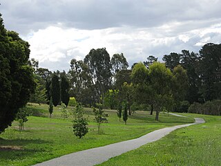
Ruffey Lake Park is a park in the City of Manningham, Melbourne, Victoria, Australia. It is situated around Ruffey Lake in a portion of a valley through which the Ruffey Creek runs, forming the border between Doncaster and Templestowe. It has three main entrances, Victoria St, The Boulevard and King St. Despite being the second largest park in Manningham, second to Westerfolds Park, it is the biggest urban park managed by the City of Manningham. It is approximately 68 hectares in size. Formerly orchards, the park has a diverse ecology; this includes a riparian strip of native bushland around the creek, areas of pine trees planted by early settlers and pockets of fruit trees remaining from past orchards.

<span class="mw-page-title-main">Geography of the Yarra River</span>

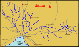
The Yarra River is a river in East-Central Victoria, Australia that flows through the city of Melbourne. This article contains explanations and lists of the river's tributaries and other geographic features. The river flows atop layers of silt that built up within an ancient river valley around 10,000-15,000 years ago.

<span class="mw-page-title-main">Lakes and reservoirs of Melbourne</span>

Melbourne is the capital city of southeastern Australian state of Victoria, and has been consistently voted one of the most liveable cities in the world. Located on the northern/eastern coastal plains of Port Phillip Bay, the city is the one of the drier capital cities in Australia, but due to its relatively flat terrain, still has many lakes. The larger lakes are used for water sports, mostly boating but some are used for recreational activities like swimming, water skiing or model boating.

<span class="mw-page-title-main">Yarran Dheran</span>

Yarran Dheran Nature Reserve forms part of the Mullum Mullum Valley and is an important riparian bushland park, located in the outer eastern suburbs of Melbourne on the border of Donvale, on the banks of the Mullum Mullum Creek. The Reserve comprises 7.2 hectares and hosts a mix of remnant and regenerated bushland, and many native species of wildlife, particularly birds, of which some 85 species may be seen over time. The Mullum Mullum Creek Trail runs through the Reserve and there are many unsealed bush tracks through the native bushland. There is an Information Centre in the Reserve which is open on Sunday afternoons from 2.00 pm – 4.00 pm subject to volunteer availability. The Reserve includes a series of ponds that feed a cascade to the creek during wet spells. There are toilets and mown areas for picnics and seating. Yarran Dheran is a Dogs on Lead Reserve.

<span class="mw-page-title-main">Warrandyte State Park</span>

Warrandyte State Park is a state park, located in Warrandyte, east of Melbourne, Victoria on the banks of the Yarra River and surroundings. The park comprises 586 hectares of remnant bushland in various locations throughout Warrandyte and Wonga Park around Pound Bend, Fourth Hill, Black Flat, Yarra Brae and various other locations in the area. It hosts many significant geographical, environmental, archaeological and historical sites, such as the site of the first gold discovery in Victoria in 1851 and preserves the sites of former gold mines and tunnels. It is a popular destination for school and community groups and is frequented by local bush walkers and hikers.

<span class="mw-page-title-main">Andersons Creek</span> Creek in Victoria, Australia

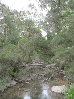
Andersons Creek is a creek in Warrandyte and Park Orchards, east of Melbourne, Victoria, Australia. It is a tributary of the Yarra River. For tens of thousands of years it was used as a food and tool source sustainably by the Wurundjeri people, Indigenous Australians of the Kulin nation, who spoke variations of the Woiwurrung language group.

References

  1. 1 2 3 Melway, Edition 36, 2009