Westerfolds is classified as a metropolitan park and conserves riparian habitat within the Melbourne urban environment. The park nestles into a hilly bend in the Yarra River and has a network of bitumen and gravel paths, shelters, playgrounds, picnic tables and electric barbecues. It is a popular spot for picnics, and family gatherings on the weekend and public holidays. Other recreational pursuits include walking, cycling, rollerblading, walking the family dog, canoeing, horse riding and bird watching.
Near the centre of the park atop a large hill lies the Manor House which housed the Mia Mia Gallery and Cafe, Indigenous Australian cultural education programs and gallery exhibiting Indigenous Australian Art. Mia Mia closed in 2013 and is no longer situated at the Park. New business tenants are currently being sought with a view to further develop, refurbish and restore the manor.
History
Aerial perspective of Odyssey House along the Yarra Main Trail, right across Westerfolds Park. Shot December 2018.
In 1846 the land was purchased from the Crown. In the early 1930s, the Turner family bought the property and built the Manor in 1936. After World War II many of the dairy farms and orchards in the surrounding area were subdivided for urban development. Because of flooding in the Yarra River, Westerfolds was not subdivided and was eventually added to the Yarra Valley Parklands in 1977. Parks Victoria (then known as Melbourne Parks and Waterways) took over the management and conservation of Westerfolds Park in 1978.
Aerial panorama of Candlebark Park alongside Fitzsimmons Reserve dog off-leash area
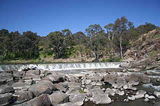
Revegetation and conservation programs are underway with the re-establishment of native grasslands and wetlands. Over 400 plant species native to the area can now be found including eucalypts, acacias, river red gums, and native grasses and shrubs. Visit in late winter and early spring to experience the wattle trees blooming throughout the park. Parrots, cockatoos, kookaburras, water and small bush birds can be seen, along with bats, platypus, wombats, koalas, possums, echidnas and, eastern grey kangaroos.
Recreation
Topdown of the nature playground at Wombat Bend Park, just west of Westerfolds ParkMain facade of the Manor House
The Yarra River Trail runs through the park. There is over 5km of sealed pathways in very good condition, much of it is of generous width with a centre dividing line, gutters and drains. Many cyclists take the paths at high speed, particularly the through-route paths as cyclists travel through the park on longer journeys. Most pedestrians are considerate of cyclists and walk on the left hand side of pathways.
Off road, there are many obscure dirt or gravel pathways winding through the bush, most of it is very flat and mainly used by casual cyclists as alternative routes to the sealed pathways. Occasionally, small mountain bike events are held on the trail in the middle of the park that crosses Kestrel Creek several times over a series of narrow boardwalks. Pedestrians occasionally use these boardwalks and it can be dangerous taking them at high speed unless the area is taped off for an event.
Walking and Running
Westerfolds Park with the Melbourne city skyline on the horizonRevegetation in 2009, planted in 2004
The 5km of sealed pathways provides excellent conditions for runners and walkers, there are 4 or 5 drinking fountains evenly distributed throughout the park, roughly every kilometre, and seats and benches at similar intervals. Schools from the surrounding area hold annual fun run events in the park, this usually involves using 2 tracks, a short loop and a longer loop. Some small change rooms are available in the toilet facilities but these are infrequently kept. Snakes are rarely encountered unless pedestrians wander onto dirt and gravel paths. Pedestrians should always remain on the left hand side of pathways to enable safe shared use by cyclists and pedestrians. It is also the location for Westerfolds parkrun. A free, weekly, timed 5km running event open to everybody.
Facilities
Map of Westerfolds Park
Manor House – toilets
Toilets (3) – in the south and north-eastern areas
Barbecues (2) – in the south and north-eastern areas
Canoe Launching Ramp – in the north-eastern area, just downstream from Fitzsimons Lane Bridge
Designated Picnic Areas (4) – in the south, south-east and north-eastern areas
Information Boards (4) – located along the sealed pathways
Viewing Platforms (2) – in the north-east and north-western areas, on the river banks overlooking rapids
Car Parking – over 100 spaces available
Access
Manor House from the eastern side
The park is open every day, including weekends and public holidays, from 8:30am to 5:00pm, and during daylight saving time from 8:30am to 8:00pm, extending to 9:00pm in peak summer periods. Access is via road through gates on Porter Street and Fitzsimons Lane, while pedestrian & cycling pathways remain open at all hours.
Newport is a suburb in Melbourne, Victoria, Australia, 10 km (6.2 mi) south-west of Melbourne's Central Business District, located within the City of Hobsons Bay local government area. Newport recorded a population of 13,658 at the 2021 census.
The Maribyrnong River Trail is a shared use path for cyclists and pedestrians, which follows the Maribyrnong River through the north western suburbs of Melbourne, Victoria, Australia.
The Diamond Creek Trail is a shared use path for cyclists and pedestrians, which follows Diamond Creek through the north eastern outer suburbs of Melbourne, Victoria, Australia.
The Merri Creek Trail is a shared use path for cyclists and pedestrians that follows the Merri Creek through the northern suburbs of Melbourne, Victoria, Australia.
The Dandenong Creek Trail is a shared use path for cyclists and pedestrians, which follows Dandenong Creek through the outer eastern and south-eastern suburbs of Melbourne, Victoria, Australia.
Jells Park is a public park in Wheelers Hill, a southeastern suburb of Melbourne, Victoria, Australia. The park opened on 30 April 1976 and is named after Joseph Jell, a cattle grazier who worked in the area in the mid-late 1800s. The park attracts in excess of 900,000 visitors a year.
Yarra Bend Park 260-hectare (640-acre) park in the Melbourne suburb of Kew. Located 4 km northeast of Melbourne's CBD, it is the largest area of natural bushland left in inner Melbourne. The most notable feature of the park is the Yarra River which flows for 12 km through it. The park hosts two golf courses, two historic boathouses, sheds and a number of cycle and walking trails. It receives approximately 1.5 million visitors per year.
Koomba Park is one of the parks comprising the Dandenong Valley Parklands in the eastern suburbs of Melbourne, Australia. It consists of 92 hectares of which 33 hectares are publicly accessible, and is bounded by Dandenong Creek, Boronia Road, EastLink, Mountain Highway and Burwood Highway in a clockwise direction. It is managed primarily by VicRoads and Parks Victoria. The park opened in December 1981, and its land was previously used for cattle grazing and apple orchards. The surrounding area is still used for grazing. There are three major power transmission lines running through the park: Rowville-Templestowe Single Circuit Southern, and Rowville-Ringwood.
The Outer Circle Trail, also known as the Anniversary Trail, Anniversary Outer Circle Trail, or even the Outer Circle Anniversary Trail, is a shared use path for cyclists and pedestrians, which partly follows the Alamein Line through the inner eastern suburbs of Melbourne, Victoria, Australia.
The Darebin Creek Trail is a shared use path for cyclists and pedestrians which follows Darebin Creek in the inner and outer northern suburbs of Melbourne, Victoria, Australia.
The Mullum Mullum Creek Trail is a shared use path for cyclists and pedestrians, which follows Mullum Mullum Creek in the outer eastern suburbs in Melbourne, Victoria, Australia.
The River Gum Walk Trail is a shared use path for cyclists and pedestrians in the suburb of Rosanna, an inner northern suburb of Melbourne, Victoria, Australia.
The Ruffey Creek Trail is a shared use path for cyclists and pedestrians, which follows Ruffey Creek in the inner eastern suburbs of Templestowe and Doncaster in Melbourne, Victoria, Australia.
Ruffey Lake Park is a park in the City of Manningham, Melbourne, Victoria, Australia. It is situated around Ruffey Lake in a portion of a valley through which the Ruffey Creek runs, forming the border between Doncaster and Templestowe. It has three main entrances, Victoria St, The Boulevard and King St. Despite being the second largest park in Manningham, second to Westerfolds Park, it is the biggest urban park managed by the City of Manningham. It is approximately 68 hectares in size. Formerly orchards, the park has a diverse ecology; this includes a riparian strip of native bushland around the creek, areas of pine trees planted by early settlers and pockets of fruit trees remaining from past orchards.
The East Gippsland Rail Trail is a rail trail located in East Gippsland in Victoria, Australia. The trail is a popular cycling route, beginning in Bairnsdale and extending to Orbost, following the route of the former Gippsland railway line. The Gippsland railway line was opened in 1916 to serve the agricultural and timber industry, and required numerous substantial bridges because of the nature of the terrain. Due to the decline in traffic and heavy operating costs, the line was finally closed in August 1987 and the track infrastructure removed in 1994. The shared trail is also available for walkers and recreational horseriding, however motorised vehicles are prohibited.
The Yarra Trail is a shared use path for cyclists and pedestrians, which follows the Yarra River through the north eastern suburbs of Melbourne, Victoria, Australia.
The Yarra River is a river in southern Victoria, Australia that flows through the city of Melbourne. There are many parklands, including state parks and national parks, that adjoin the river along its 250 km length. Every park listed has walking tracks, smaller parks usually have unsealed paths, while bigger parks will have sealed pathways suitable for walking and cycling. The Yarra River Trail runs along much of the length of the river's lower reaches through Melbourne. Most parks listed have parking available, the quality and quantity of which varies according to the size of the park. Dogs are not permitted in parklands adjoining the river unless otherwise stated in special off-lead areas.
The Longbeach Trail is a shared-use bicycle and pedestrian path running from Patterson River, Carrum, along the southwestern side of the Edithvale-Seaford Wetlands, to the Mordialloc Creek, Mordialloc. In Mordialloc, it connects to the Mordialloc Creek Trail and the Bay Trail and in the Carrum it connects to the Bay Trail and Dandenong Creek Trail.
Koonung Creek Reserve is a linear park in the suburb of Balwyn North, Melbourne, Australia. It follows the path of the Eastern Freeway from Bulleen Road in the west to Doncaster Road to the east.
The Bay Trail is a shared use path for cyclists and pedestrians which follows the coastline of Port Phillip Bay through the south-eastern suburbs of Melbourne, Victoria, Australia.
This page is based on this Wikipedia article Text is available under the CC BY-SA 4.0 license; additional terms may apply. Images, videos and audio are available under their respective licenses.