Pittsburgh, Harmony, Butler and New Castle Railway

Last updated

Pittsburgh, Harmony, Butler and New Castle Railway
Overview
Headquarters Pittsburgh, Pennsylvania
Locale Western Pennsylvania
Dates of operation1908 (1908)1931 (1931)
SuccessorPittsburgh, Mars and Butler Railway
Technical
Track gauge 5 ft 2+12 in (1,588 mm)
Length118 miles (190 km)
Pittsburgh, Mars and Butler
BSicon uexKBHFa.svg
New Castle
BSicon uexLSTR.svg
BSicon uexHST.svg
Cascade Park
BSicon uexHST.svg
W.A.R.R. Depot
BSicon uexHST.svg
E. New Castle
BSicon uexHST.svg
Rozzi
BSicon uexHST.svg
Wilkinson
BSicon uexHST.svg
Gardner
BSicon uexHST.svg
Weir
BSicon uexHST.svg
Shenango
BSicon uexHST.svg
Rose
BSicon uexHST.svg
Energy
BSicon uexHST.svg
Cox
BSicon uexHST.svg
Baldwin
BSicon uexHST.svg
Moravia
BSicon uexHST.svg
Springs
BSicon uexHST.svg
Marquis
BSicon uexHST.svg
Smiley
BSicon uexHST.svg
Wayne
BSicon uexHST.svg
Slippery Rock
BSicon uexHST.svg
Wilson
BSicon uexHST.svg
Hazel Dell
BSicon uexSTR+l.svg
BSicon uexBHFABZgr+r.svg
Elwood Junction
BSicon uexSTR.svg
BSicon uexLSTR.svg
BSicon uexSTR.svg
BSicon uexHST.svg
Wurtemburg
BSicon uexSTR.svg
BSicon uexHST.svg
Knox
BSicon uexSTR.svg
BSicon uexHST.svg
Frisco
BSicon uexSTR.svg
BSicon uexHST.svg
Hazen
BSicon uexSTR.svg
BSicon uexHST.svg
N. Sewickley
BSicon uexSTR.svg
BSicon uexHST.svg
Elwood Country Club
BSicon uexSTR.svg
BSicon uexHST.svg
Jackson
BSicon uexSTR.svg
BSicon uexHST.svg
Rustick Park
BSicon uexSTR.svg
BSicon uexHST.svg
Willow Grove
BSicon uexSTR.svg
BSicon uexHST.svg
River View
BSicon uexSTR.svg
BSicon uexHST.svg
Marion
BSicon uexSTR.svg
BSicon uexHST.svg
Eckert
BSicon uexSTR.svg
BSicon uexHST.svg
Goemring
BSicon uexSTR.svg
BSicon uexHST.svg
Fombell
BSicon uexSTR.svg
BSicon uexHST.svg
Spruce Hill
BSicon uexSTR.svg
BSicon uexHST.svg
Pine Run
BSicon uexSTR.svg
BSicon uexHST.svg
Pflugh
BSicon uexSTR.svg
BSicon uexHST.svg
Ben Venue
BSicon uexSTR.svg
BSicon uexHST.svg
Valley
BSicon uexSTR.svg
BSicon uexHST.svg
Allen
BSicon uexSTR.svg
BSicon uexHST.svg
Lockwood
BSicon uexSTR.svg
BSicon uexBHF.svg
Zelienople
BSicon uexSTR.svg
BSicon uexHST.svg
Harmony Jct.
BSicon uexSTR.svg
BSicon uexHST.svg
Knights Pythias
BSicon uexSTR.svg
BSicon uexHST.svg
Nurseries
BSicon uexSTR.svg
BSicon uexHST.svg
Ziegler
BSicon uexHST.svg
BSicon uexSTR.svg
Burnstown
BSicon uexBHF.svg
BSicon uexSTR.svg
Elwood
BSicon uexLSTR.svg
BSicon uexSTR.svg
BSicon uexHST.svg
BSicon uexSTR.svg
Church
BSicon uexHST.svg
BSicon uexSTR.svg
Park Gate
BSicon uexHST.svg
BSicon uexSTR.svg
Hartman
BSicon uexHST.svg
BSicon uexSTR.svg
Belton
BSicon uexHST.svg
BSicon uexSTR.svg
Toll House
BSicon uexHST.svg
BSicon uexSTR.svg
Hoyt Dale
BSicon uexHST.svg
BSicon uexSTR.svg
Koppel
BSicon uexHST.svg
BSicon uexSTR.svg
Koppel Sub. Sta.
BSicon uexHST.svg
BSicon uexSTR.svg
So. Koppel
BSicon uexHST.svg
BSicon uexSTR.svg
Homewood
BSicon uexHST.svg
BSicon uexSTR.svg
Horne
BSicon uexHST.svg
BSicon uexSTR.svg
Grimm
BSicon uexHST.svg
BSicon uexSTR.svg
Morado
BSicon uexKBHFe.svg
BSicon uexSTR.svg
Beaver Falls
BSicon uexSTR+l.svg
BSicon uexSTRr.svg
BSicon uexKBHFa.svg
Butler
BSicon uexSTR.svg
BSicon uexSTR+l.svg
BSicon uexABZgr.svg
BSicon uexSTR.svg
BSicon uexLSTR.svg
BSicon uexSTR.svg
BSicon uexSTR.svg
BSicon uexHST.svg
BSicon uexSTR.svg
Pierce
BSicon uexSTR.svg
BSicon uexHST.svg
BSicon uexSTR.svg
Lyndora
BSicon uexSTR.svg
BSicon uexHST.svg
BSicon uexSTR.svg
Highfield
BSicon uexSTR.svg
BSicon uexHST.svg
BSicon uexSTR.svg
Duffey
BSicon uexSTR.svg
BSicon uexHST.svg
BSicon uexSTR.svg
Eberhart
BSicon uexSTR.svg
BSicon uexHST.svg
BSicon uexSTR.svg
Woodlawn
BSicon uexSTR.svg
BSicon uexHST.svg
BSicon uexSTR.svg
Miller
BSicon uexSTR.svg
BSicon uexHST.svg
BSicon uexSTR.svg
Meridian
BSicon uexSTR.svg
BSicon uexHST.svg
BSicon uexSTR.svg
Cupps
BSicon uexSTR.svg
BSicon uexHST.svg
BSicon uexSTR.svg
Reiber
BSicon uexSTR.svg
BSicon uexHST.svg
BSicon uexSTR.svg
Walker
BSicon uexSTR.svg
BSicon uexHST.svg
BSicon uexSTR.svg
Graham
BSicon uexSTR.svg
BSicon uexHST.svg
BSicon uexSTR.svg
Connoquenessing
BSicon uexSTR.svg
BSicon uexHST.svg
BSicon uexSTR.svg
Forward
BSicon uexSTR.svg
BSicon uexHST.svg
BSicon uexSTR.svg
Buhl
BSicon uexSTR.svg
BSicon uexHST.svg
BSicon uexSTR.svg
Ash
BSicon uexSTR.svg
BSicon uexHST.svg
BSicon uexSTR.svg
Stamm
BSicon uexSTR.svg
BSicon uexHST.svg
BSicon uexSTR.svg
Dambach
BSicon uexSTR.svg
BSicon uexHST.svg
BSicon uexSTR.svg
Walden
BSicon uexABZg+l.svg
BSicon uexSTRr.svg
BSicon uexLSTR.svg
BSicon uexSTR.svg
BSicon uexHST.svg
Bredanville
BSicon uexSTR.svg
BSicon uexHST.svg
Kummer
BSicon uexSTR.svg
BSicon uexHST.svg
Leibler
BSicon uexSTR.svg
BSicon uexHST.svg
Odell
BSicon uexSTR.svg
BSicon uexHST.svg
Phillips
BSicon uexSTR.svg
BSicon uexHST.svg
McCalmont
BSicon uexSTR.svg
BSicon uexHST.svg
Renfrew
BSicon uexSTR.svg
BSicon uexHST.svg
Thorne Creek
BSicon uexSTR.svg
BSicon uexHST.svg
McBride
BSicon uexSTR.svg
BSicon uexHST.svg
Brown
BSicon uexSTR.svg
BSicon uexHST.svg
Yingling
BSicon uexSTR.svg
BSicon uexHST.svg
Butler C. Club
BSicon uexSTR.svg
BSicon uexHST.svg
Nixon
BSicon uexSTR.svg
BSicon uexHST.svg
Duffey
BSicon uexSTR.svg
BSicon uexHST.svg
Star
BSicon uexSTR.svg
BSicon uexHST.svg
Conabee
BSicon uexSTR.svg
BSicon uexHST.svg
Adams
BSicon uexSTR.svg
BSicon uexHST.svg
Hughes
BSicon uexSTR.svg
BSicon uexHST.svg
Lloyd
BSicon uexSTR.svg
BSicon uexHST.svg
Hayes
BSicon uexSTR.svg
BSicon uexHST.svg
Pershing
BSicon uexSTR.svg
BSicon uexHST.svg
Rosebaugh
BSicon uexSTR.svg
BSicon uexHST.svg
McCandless
BSicon uexSTR.svg
BSicon uexHST.svg
Humes
BSicon uexSTR.svg
BSicon uexHST.svg
Hutchman
BSicon uexSTR.svg
BSicon uexHST.svg
Cashdollar
BSicon uexSTR.svg
BSicon uexHST.svg
Ludwig
BSicon uexBHF.svg
BSicon uexSTR.svg
Evans City
BSicon uexSTR.svg
BSicon uexBHF.svg
Mars
BSicon uexLSTR.svg
BSicon uexSTR.svg
BSicon uexHST.svg
BSicon uexSTR.svg
May
BSicon uexHST.svg
BSicon uexSTR.svg
Irwin
BSicon uexHST.svg
BSicon uexSTR.svg
Marburger
BSicon uexHST.svg
BSicon uexSTR.svg
Callery
BSicon uexHST.svg
BSicon uexSTR.svg
Kaufman
BSicon uexHST.svg
BSicon uexSTR.svg
Kiser
BSicon uexHST.svg
BSicon uexSTR.svg
Burke
BSicon uexHST.svg
BSicon uexSTR.svg
West
BSicon uexHST.svg
BSicon uexSTR.svg
Plains Church
BSicon uexHST.svg
BSicon uexSTR.svg
Frankilin Rd.
BSicon uexHST.svg
BSicon uexSTR.svg
Rowan
BSicon uexHST.svg
BSicon uexSTR.svg
Criders
BSicon uexHST.svg
BSicon uexSTR.svg
Dutihl
BSicon uexHST.svg
BSicon uexSTR.svg
Thornhill
BSicon uexHST.svg
BSicon uexSTR.svg
School
BSicon uexHST.svg
BSicon uexSTR.svg
Robinson
BSicon uexHST.svg
BSicon uexSTR.svg
Fowler
BSicon uexHST.svg
BSicon uexSTR.svg
Warrendale
BSicon uexHST.svg
BSicon uexSTR.svg
Wheatland
BSicon uexHST.svg
BSicon uexSTR.svg
Bradford Woods
BSicon uexHST.svg
BSicon uexSTR.svg
Burmar
BSicon uexHST.svg
BSicon uexSTR.svg
Brennan
BSicon uexHST.svg
BSicon uexSTR.svg
Wexford
BSicon uexHST.svg
BSicon uexSTR.svg
Crystal Springs
BSicon uexHST.svg
BSicon uexSTR.svg
Richards
BSicon uexHST.svg
BSicon uexSTR.svg
Biening
BSicon uexHST.svg
BSicon uexSTR.svg
Pine Creek
BSicon uexHST.svg
BSicon uexSTR.svg
Ingomar
BSicon uexHST.svg
BSicon uexSTR.svg
Glen Manor
BSicon uexHST.svg
BSicon uexSTR.svg
Willoughby
BSicon uexHST.svg
BSicon uexSTR.svg
Peets
BSicon uexHST.svg
BSicon uexSTR.svg
Brants
BSicon uexHST.svg
BSicon uexSTR.svg
Highland
BSicon uexHST.svg
BSicon uexSTR.svg
Perrymont
BSicon uexHST.svg
BSicon uexSTR.svg
Kaylor
BSicon uexHST.svg
BSicon uexSTR.svg
Pines
BSicon uexHST.svg
BSicon uexSTR.svg
Keown
BSicon uexHST.svg
BSicon uexSTR.svg
Mellwood
BSicon uexHST.svg
BSicon uexSTR.svg
North Ivory
BSicon uexHST.svg
BSicon uexSTR.svg
Heim
BSicon uexHST.svg
BSicon uexSTR.svg
Evergreen
BSicon uexHST.svg
BSicon uexSTR.svg
McCutcheon
BSicon uexHST.svg
BSicon uexSTR.svg
Brookview
BSicon uexHST.svg
BSicon uexSTR.svg
Brooks
BSicon uexHST.svg
BSicon uexSTR.svg
Myers
BSicon uexHST.svg
BSicon uexSTR.svg
Eakin
BSicon uexHST.svg
BSicon uexSTR.svg
Belper
BSicon uexHST.svg
BSicon uexSTR.svg
Ross
BSicon uexHST.svg
BSicon uexSTR.svg
Ivory
BSicon uexSTR.svg
BSicon uexLSTR.svg
BSicon uexSTR.svg
BSicon uexHST.svg
Brickworks
BSicon uexSTR.svg
BSicon uexHST.svg
Dight
BSicon uexSTR.svg
BSicon uexHST.svg
Downieville
BSicon uexSTR.svg
BSicon uexHST.svg
Valencia
BSicon uexSTR.svg
BSicon uexHST.svg
Arcadia
BSicon uexSTR.svg
BSicon uexHST.svg
State Road
BSicon uexSTR.svg
BSicon uexHST.svg
Bakerstown
BSicon uexSTR.svg
BSicon uexHST.svg
St. Barnabas
BSicon uexSTR.svg
BSicon uexHST.svg
McKelvey
BSicon uexSTR.svg
BSicon uexHST.svg
Dickey
BSicon uexSTR.svg
BSicon uexHST.svg
Gibsonia
BSicon uexSTR.svg
BSicon uexHST.svg
Richland Hts.
BSicon uexSTR.svg
BSicon uexHST.svg
Gemsys Hts.
BSicon uexSTR.svg
BSicon uexHST.svg
Smith
BSicon uexSTR.svg
BSicon uexHST.svg
Hardies
BSicon uexSTR.svg
BSicon uexHST.svg
Hampton
BSicon uexSTR.svg
BSicon uexHST.svg
Poff
BSicon uexSTR.svg
BSicon uexHST.svg
Bardona
BSicon uexSTR.svg
BSicon uexHST.svg
Wickline
BSicon uexSTR.svg
BSicon uexHST.svg
Health Farm
BSicon uexSTR.svg
BSicon uexHST.svg
Wildwood
BSicon uexSTR.svg
BSicon uexHST.svg
Sample
BSicon uexSTR.svg
BSicon uexHST.svg
W. Hoffman
BSicon uexSTR.svg
BSicon uexHST.svg
McCune
BSicon uexSTR.svg
BSicon uexHST.svg
Furgason
BSicon uexSTR.svg
BSicon uexHST.svg
Allison Park
BSicon uexSTR.svg
BSicon uexHST.svg
Elfinwild
BSicon uexSTR.svg
BSicon uexHST.svg
Mt. Royal
BSicon uexSTR.svg
BSicon uexHST.svg
Vilsack
BSicon uexSTR.svg
BSicon uexHST.svg
Stock Farm
BSicon uexSTR.svg
BSicon uexHST.svg
Glenshaw
BSicon uexSTR.svg
BSicon uexHST.svg
Under Cliff
BSicon uexSTR.svg
BSicon uexHST.svg
Braun
BSicon uexSTR.svg
BSicon uexHST.svg
Broadway
BSicon uexSTR.svg
BSicon uexHST.svg
Gibson
BSicon uexSTR.svg
BSicon uexHST.svg
Shaler Hts.
BSicon uexSTR.svg
BSicon uexHST.svg
Etna
BSicon uexSTRl.svg
BSicon uexBHFq.svg
BSicon uexSTRr.svg
Pittsburgh (Liberty and Market)

The Pittsburgh, Harmony, Butler and New Castle Railway, commonly called the Harmony Line, was a broad gauge [1] interurban streetcar line connecting Pittsburgh, Pennsylvania, United States to Butler and New Castle via Harmony and a split at Evans City. There was also an extension that was later added to the line from Ellwood City to Beaver Falls.

Contents

The company had a freight station in downtown Pittsburgh on the north side of Duquesne Way just west of Barbeau Street. This connected to trackage on Duquesne Way.

History

Pittsburgh, Harmony, Butler and New Castle Railway

The railway was developed by business partners Russel H. Boggs and Henry Buhl as an adjunct to their department store in Pittsburgh. Mr. Boggs already had a business relationship with many of the farms between Evans City and Pittsburgh and proposed exchanging the right of way across their land for one dollar, a guaranteed trolley stop and an electricity supply. [2] A first step in consolidation of 11 small railways into Harmony, Butler and New Castle Railway happened when the corporation was formed in 1906. The new corporation officers were President Stanley C. Vickers; vice President Harry Ethridge; Secretary, E.M. Baisinger; Treasurer, Mark G. Hibbs, all of Pittsburgh. [3] The first trolley ran to Ellwood City on July 2, 1908. At the southern end of the line Pittsburgh Railways took over the trolley for the run into Pittsburgh, as the final few miles was over their rails. In 1914 an extension along the Beaver Valley was opened. This left Ellwood City heading south west and crossed the Beaver River on Koppel Bridge which was built for the purpose. This bridge also carried vehicle and pedestrian traffic and was subject to a toll.

Pittsburgh, Mars and Butler Railway

In 1917, the railway amalgamated with the Pittsburgh and Butler Street Railway , who operated the Butler Short Line between Pittsburgh and Butler, the new company being named the Pittsburgh, Mars and Butler Railway. [4] The new combined system had a length of 118 miles (190 km). [5] In 1922 the railway formed the Harmony Short Line Motor Transportation Company to carry freight between Bakerstown, and Butler. Bus services were introduced in 1923 alongside the Beaver Falls line, with Ellwood City and New Castle being added in 1924 and Butler to New Castle in 1925. Over the next 5 years further services were added, supplementing and paralleling trolley lines. [6]

In April 1931, the company went into receivership. The Butler Short Line was closed on April 22, 1931 [7] as it was in poor condition, services being absorbed into the existing PA 8 bus service. Beaver Falls – Ellwood City – New Castle services were replaced by buses on June 15, 1931. [6] The remaining lines were replaced by buses on the same day, with the final trolley running on August 15, 1931. [2] The stub of the Butler Short Line continued to be used by Pittsburgh Railways as the 2 Etna service until closure in 1952. [8]

Routes in 1915

Evans City

All stops to Evans City departing Liberty and Market at 6:15 and every hour until 23:15. Change at Evans City for Butler or New Castle. [9]

Butler Harmony route

Limited stop direct to Butler departing Liberty and Market at 7:45 and every hour until 19:45 with a late car at 23:50. [9]

New Castle, Harmony route

Limited stop direct to New Castle departing Liberty and Market at 7:45 and every hour until 19:45 with a late car at 23:50. [9]

Incidents

A passenger car on the Pittsburgh, Harmony, Butler and New Castle Railway hit an open switch and crashed into a freight car on May 30, 1912. It was traveling at 35 miles per hour (56 km/h) near Harmony and 38 were injured in the impact. [10]

Raymond Robinson

In 1919, nine-year-old Raymond was severely burnt by a loose powerline, causing severe disfigurement. He became an urban legend as he only went out at night.[ citation needed ]

Preservation

Car 115 avoided being burnt when the line closed as it had mechanical problems and had been abandoned where it failed. It became a roadside diner, The Dew Drop Inn, a role it maintained until being extracted from what was now a large restaurant and recovered to the Pennsylvania Trolley Museum where it awaits restoration. [11] In this way it avoided being burnt twice, as the inn was destroyed by fire in 1995. [12] In addition to this car the museum also has the original Harmony dispatch board and a shelter from both the Harmony and Butler lines. [5]

The station building in Ellwood City was retained as commercial premises. In 2007 it reopened as a donut shop and was renamed Ellwood Station as a reference to its origin. Rails remain in situ under part of the building. [13]

Koppel Bridge, which was built for the Beaver Valley extension in 1915 still exists and carries PA 351 over the Beaver River between Ellwood City and Koppel. [14]

Related Research Articles

<span class="mw-page-title-main">Butler, Pennsylvania</span> City in Pennsylvania, United States

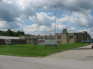
Butler is a city and the county seat of Butler County, Pennsylvania, United States. It is located 35 miles (56 km) north of Pittsburgh and is part of the Greater Pittsburgh region. As of the 2020 census, the city population was 13,502.

<span class="mw-page-title-main">Homeacre-Lyndora, Pennsylvania</span> Census-designated place in Pennsylvania, United States

Homeacre-Lyndora is a census-designated place (CDP) in Butler County, Pennsylvania, United States. The population was 6,906 at the 2010 census.

<span class="mw-page-title-main">Meridian, Pennsylvania</span> Census-designated place in Pennsylvania, United States

Meridian is a census-designated place (CDP) in Butler County, Pennsylvania, United States. The population was 3,881 at the 2010 census.

<span class="mw-page-title-main">Zelienople, Pennsylvania</span> Borough in Pennsylvania, United States

Zelienople is a borough in Butler County, Pennsylvania, 28 miles (45 km) north of Pittsburgh. The population was 3,812 at the 2010 census. It is part of the Pittsburgh metropolitan area.

<span class="mw-page-title-main">Shenango Township, Lawrence County, Pennsylvania</span> Township in Pennsylvania, United States

Shenango Township is a township in Lawrence County, Pennsylvania, United States. The population was 7,133 at the 2020 census, a decline from the figure of 7,479 tabulated in 2010. Shenango Township is situated between the city of New Castle to the north and the borough of Ellwood City to the south.

<span class="mw-page-title-main">Slippery Rock Township, Lawrence County, Pennsylvania</span> Township in Pennsylvania, United States

Slippery Rock Township is a township in Lawrence County, Pennsylvania, United States. As of the 2020 census, the population was 2,913, a decline from the figure of 3,283 tabulated in 2010.

<span class="mw-page-title-main">Wayne Township, Lawrence County, Pennsylvania</span> Township in Pennsylvania, United States

Wayne Township is a township in Lawrence County, Pennsylvania, United States. The population was 2,468 at the 2020 census, a decline from the figure of 2,606 tabulated in 2010.

The Pittsburgh and Lake Erie Railroad, also known as the "Little Giant", was formed on May 11, 1875. Company headquarters were located in Pittsburgh, Pennsylvania. The line connected Pittsburgh in the east with Youngstown, Ohio in the Haselton neighborhood in the west and Connellsville, Pennsylvania to the east. It did not reach Lake Erie until the formation of Conrail in 1976. The P&LE was known as the "Little Giant" since the tonnage that it moved was out of proportion to its route mileage. While it operated around one tenth of one percent of the nation's railroad miles, it hauled around one percent of its tonnage. This was largely because the P&LE served the steel mills of the greater Pittsburgh area, which consumed and shipped vast amounts of materials. It was a specialized railroad deriving much of its revenue from coal, coke, iron ore, limestone, and steel. The eventual closure of the steel mills led to the end of the P&LE as an independent line in 1992.

<span class="mw-page-title-main">Glenwood Bridge</span> Bridge in Pittsburgh, Pennsylvania

The Glenwood Bridge is a cantilever bridge in Pittsburgh, Pennsylvania, which carries Pennsylvania Route 885 over the Monongahela River. It started construction on June 3, 1958. It was completed in 1966 to replace an old, decayed, unsafe iron bridge built in 1894, which carried Pittsburgh Railways streetcar tracks and vehicle traffic on a wooden deck.

<span class="mw-page-title-main">Pittsburgh Railways</span>

Pittsburgh Railways was one of the predecessors of Pittsburgh Regional Transit. It had 666 PCC cars, the third largest fleet in North America. It had 68 streetcar routes, of which only three are used by the Port Authority as light rail routes. With the Port Authority's Transit Development Plan, many route names will be changed to its original, such as the 41D Brookline becoming the 39 Brookline. Many of the streetcar routes have been remembered in the route names of many Port Authority buses.

<span class="mw-page-title-main">Transportation in Pittsburgh</span> Transportation in Pittsburgh, Pennsylvania, United States

Pittsburgh, surrounded by rivers and hills, has a unique transportation infrastructure that includes roads, tunnels, bridges, railroads, inclines, bike paths, and stairways. The hills and rivers form many barriers to transportation within the city.

<span class="mw-page-title-main">Pittsburgh Light Rail</span> Light rail system in Pittsburgh, Pennsylvania

The Pittsburgh Light Rail is a 26.2-mile (42.2 km) light rail system in Pittsburgh, Pennsylvania, and surrounding suburbs. It operates as a deep-level subway in Downtown Pittsburgh, but runs mostly at-grade in the suburbs south of the city. The system is largely linear in a north-south direction, with one terminus near Pittsburgh's central business district and two termini in the South Hills. The system is owned and operated by Pittsburgh Regional Transit. The T is one of the surviving first-generation streetcar systems in North America, with the oldest portions of the network dating back to 1903 and the Pittsburgh Railways. It is also one of only three light rail systems in the United States that continues to use the broad 5 ft 2+12 in Pennsylvania Trolley Gauge on its lines instead of the 4 ft 8+12 instandard gauge. In 2022, the system had a ridership of 2,429,500.

The Youngstown and Ohio River Railroad, or Y&OR, was one of the smaller interurban railways in the state of Ohio. Along with the Youngstown and Southern Railway, the Y&OR formed a traction link between Youngstown, Ohio and the Ohio River at East Liverpool. It served several coal mines in the area and it was distinguished by the unusual feat of electrifying a section of a steam railroad, the Pittsburgh, Lisbon and Western Railroad, as part of a trackage rights agreement. The Y&OR operated for 24 years.

<span class="mw-page-title-main">Pennsylvania Route 351</span> State highway in Pennsylvania, US

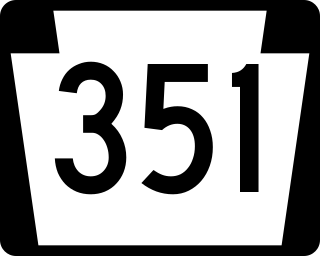
Pennsylvania Route 351 is a 17.2-mile-long (27.7 km) state highway located in Lawrence and Beaver counties in Pennsylvania. The western terminus is at the Ohio border in Little Beaver Township. The eastern terminus is at PA 65/PA 288 in Ellwood City. It is famous for its spotting of Raymond Robinson who would go on nighttime walks on the route making him an Urban legend.

<span class="mw-page-title-main">Raymond Robinson (Green Man)</span> American urban legend

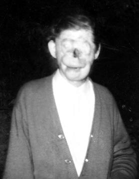
Raymond Theodore Robinson was a disfigured American man whose years of nighttime walks made him into a figure of urban legend in western Pennsylvania. Robinson was so severely injured in a childhood electrical accident that he could not go out in public without fear of causing a panic, so he went for long walks at night. Local tourists would drive along his road in hopes of meeting the Green Man or Charlie No-Face; they became disappointed to see no such person. However, they passed on tales about him to their children and grandchildren regardless, and people raised on these tales are sometimes surprised to discover that he was a real person who was liked by his family and neighbors.

Pennsylvania State Senate District 47 includes parts of Beaver County, Butler County, and Lawrence County. It is currently represented by Republican Elder Vogel.

<span class="mw-page-title-main">West Penn Railways</span>

West Penn Railways, one part of the West Penn System, was an interurban electric railway headquartered in Connellsville, Pennsylvania. It was part of the region's power generation utility.

<span class="mw-page-title-main">Butler station (MBTA)</span> Light rail station in Boston

Butler station is a light rail station in Boston, Massachusetts. It serves the MBTA Ashmont–Mattapan High-Speed Line. It is located at Butler Street in the Lower Mills section of the Dorchester neighborhood. It serves a small residential area sandwiched between the Neponset River, Cedar Grove Cemetery, and Dorchester Park. Butler station has no MBTA bus connections. It is accessible via a wooden mini-high ramp on the station's single island platform.

<span class="mw-page-title-main">Mount Washington Transit Tunnel</span>

Mount Washington Transit Tunnel is an important public transportation link in Pittsburgh, Pennsylvania, United States. The 3,492-foot (1,064 m) tunnel connects Station Square to South Hills Junction, and is used only by Pittsburgh Light Rail cars and buses of the Port Authority of Allegheny County. The tunnel changes 204.54 feet in elevation from its north portal at 750.36 feet above sea level to its south portal at 954.90 feet above sea level, resulting in a grade of 5.86%. With the cessation of bus service in the Downtown Seattle Transit Tunnel in 2019, the Mount Washington Transit Tunnel is the only tunnel in the United States shared by bus and rail services.

<span class="mw-page-title-main">Pittsburgh and Butler Street Railway</span>

The Pittsburgh and Butler Street Railway, commonly called the Butler Short Line, was a broad gauge interurban streetcar line connecting Pittsburgh, Pennsylvania, United States to Butler via Mars.

References

  1. William D. Middleton (1961). The Interurban Era. Kalmbach Publishing. p.  113.
  2. 1 2 Ben (February 24, 2009). "The Pittsburgh, Harmony, Butler, and New Castle Railway". Ellwood City Memories. Archived from the original on July 10, 2011. Retrieved March 4, 2017.
  3. Railway Review, Volume 46, June 6, 1906 page 431 Railway Review, Volume 46, June 6, 1906 page 431
  4. "Rachel Carson Trails – Harmony Trail". February 3, 2007. Retrieved September 2, 2009.
  5. 1 2 Joseph F. Stierheim (October 3, 2004). "Harmony Line system ahead of its time". Pittsburgh Tribune Review. Retrieved November 22, 2009.
  6. 1 2 "The Antique Motor Coach Association of Pennsylvania – Harmony Short Line". 2008. Retrieved September 16, 2009.
  7. "Zelienople Historical Society – The Harmony Line – The End of an Era". 2004. Archived from the original on July 6, 2010. Retrieved October 4, 2009.
  8. "Pittsburghtransit.com – The Routes – PCC Operation". August 28, 2005. Archived from the original on August 28, 2005. Retrieved August 9, 2009.
  9. 1 2 3 Lewis' Pittsburgh Street & Trolly(sic) Guide. Pittsburgh: Lewis Publishing Company. 1915. pp. 185–200. Retrieved December 22, 2017.
  10. "38 HURT IN TROLLEY CRASH.; Pittsburgh Suburban Coach Runs Into an Open Switch" (PDF). New York Times. May 31, 1912. Retrieved November 28, 2009.
  11. "Pennsylvania Trolley Museum – Pittsburgh, Harmony, Butler & New Castle Railway Car No. 115". October 17, 2005. Archived from the original on January 12, 2006. Retrieved September 17, 2009.
  12. Steve Mellon (August 25, 2005). "Spring avenue donut shop brought back to life". Pittsburgh Post Gazette. Retrieved October 31, 2009.
  13. Eric Pool (July 14, 2007). "Spring avenue donut shop brought back to life". Ellwood City Ledger. Archived from the original on June 8, 2011. Retrieved October 25, 2009.
  14. "Historic bridges of the United States – Koppel Bridge". 2009. Retrieved November 22, 2009.